The Vietnam Veterans Memorial Trail is a 9.2 mile paved loop trail situated in Calverton, New York near the “North Fork” of Long Island.
It’s also locally known as the “EPCAL Bike Path.” EPCAL stands for “Enterprise Park CALverton”, which is a sprawling 2,900-acre business and enterprise park with a private (although inactive) airport in the middle, and the multi-use path ringing its borders.
Calverton? Riverhead? Where Is It?
The park – and the trail – is situated in the area known as Calverton, New York. But if you search for this trail, you may sometimes find it referred to as being in “Riverhead”.

Technically this is correct, even though if you look on a map, the town of Riverhead, as many parts of the U.S. consider “towns”, is actually almost 8 miles away from this trail.
The reason for this is how New York State, and particularly Long Island, classifies “towns.”
According to sources, the “town” designation is given to a municipal corporation that comprise smaller communities within it, that aren’t already assigned to a city or a Native American reservation. This is similar to the “township” designation that’s used in various states (including my own).
Within a “town” on Long Island, smaller communities include villages (smaller municipal areas formed by residents in order to provide themselves with municipal services) and hamlets (unincorporated areas that are governed by and receive municipal services from the town in which they are placed).
One of the most concise explanations of this difference was written by a husband and wife real estate team, and can be viewed here.
History of the Trail
Construction on the Vietnam Veterans Memorial Trail began in 2008 with the aid of state grants. About 3 miles of it were opened in short order.


Afterward, Riverhead Town acquired additional funding from Suffolk County and New York State to complete the total 9.2 mile fully-paved loop trail. The trail was fully opened to the public in 2019.
History of the Site
The history of the site itself is pretty interesting.
Back in the middle portion of the 20th century, the area was administered by the US Navy and was known as the “Naval Weapons Industrial Reserve Plant”.


The Navy contracted aerospace firm Grumman (now Northrup Grumman) to use the site to develop and test some famous military aircraft for the Navy. These included the A-6 Intruder, E-2 Hawkeye, F-14 Tomcat, and F-11 Tiger. Two runways were built on the site, with the eastern runway measuring 10,000 feet long. The site also held Grumman’s “Plant Six”, where final assembly of F-14s, A-6s, EA-6Bs, and E-2Cs took place.
Grumman Wasn’t Just For Military Aircraft
Incidentally, Grumman is famous as the designer and builder of the Lunar Module (LEM or LM) for NASA, which flew a number of astronauts to the Moon – and also became arguably America’s most famous “lifeboat” during the Apollo 13 mission.


And while the Lunar Modules were manufactured at Grumman’s Bethpage facility (in Nassau County, western Long Island), it’s said that several astronauts visited the Calverton site in the 1970s, because Grumman built a mock-up of the lunar surface on the site to test their Lunar Roving Vehicle there.
Grumman Memorial Park sits at the northern edge of the property, along New York State Route 25 (Middle Country Road). The park is accessible from the trail itself.
Other Notable Uses
In 1996, the wreckage of TWA Flight 800 (which exploded and crashed about 20 miles south of the airport), was reconstructed in a hangar at the airpark and restored by the National Transportation Safety Board to be used as an accident investigation teaching aid. After 2021, the wreckage was dismantled and removed.
While most of the land transferred ownership from the U.S. Navy/Grumman (as the contractor) to Riverhead Town, it is reported that the Navy still owns about 350 acres or so of the site, mostly the areas requiring environmental cleanup from its former use as a military contract site.
In 2021, the Town Board of Riverhead voted to approve the use of the runways to host a National Hot Rod Association (NHRA) Division 1 racing event that took place that summer. According to available sources, while the NHRA has not hosted any sanctioned races at the airpark since, there have been other non-NHRA races there more recently, promoted under the banner of the “EPCAL Racing Series.”
Trail Details
Length, Width, Barriers
The Vietnam Veterans Memorial Trail/EPCAL Bike Path is a measured 9.2 mile loop trail. It is fully paved with an average treadway width of 8 feet, though some portions have varied widths from 10 to 16 feet.

Trail barriers mostly consist of a single wood, metal, or PVC barrier in the middle of the treadway, with occasional edge barriers.
Surface
The trail is mostly flat with a few gentle grades and one short-distance grade that’s about a 2% slope, but I don’t think they’re at all challenging, even for a newer cyclist.
There are also a good number of curves on this trail, including several 90° bends that should be traversed more slowly. Fortunately, the trail managers have painted yellow center lines around these sharp curves, so that you can see when they’re coming. Some of these 90° curves (unfortunately not all of them) have a convex mirror mounted on the outer part of the curve so that you can see if someone’s coming from the other direction.


If you take a look at the accompanying video for this trail, you can see where I take some of these curves. I do confess that the video looks like I’m taking them faster than 15 mph, but that’s because I cut to the view from my low-mounted camera, just for the cool effect of going around a 90° curve from the “bicycle’s perspective”!
While the surface is fully paved, be on the lookout for several broken/uplifted areas of pavement. Some of them can really jar you if you ride over them too fast. I’ve pointed out a few of them on the accompanying video for this trail (filmed in August 2025), but hopefully Riverhead Town will have smoothed them over by now.
Signage
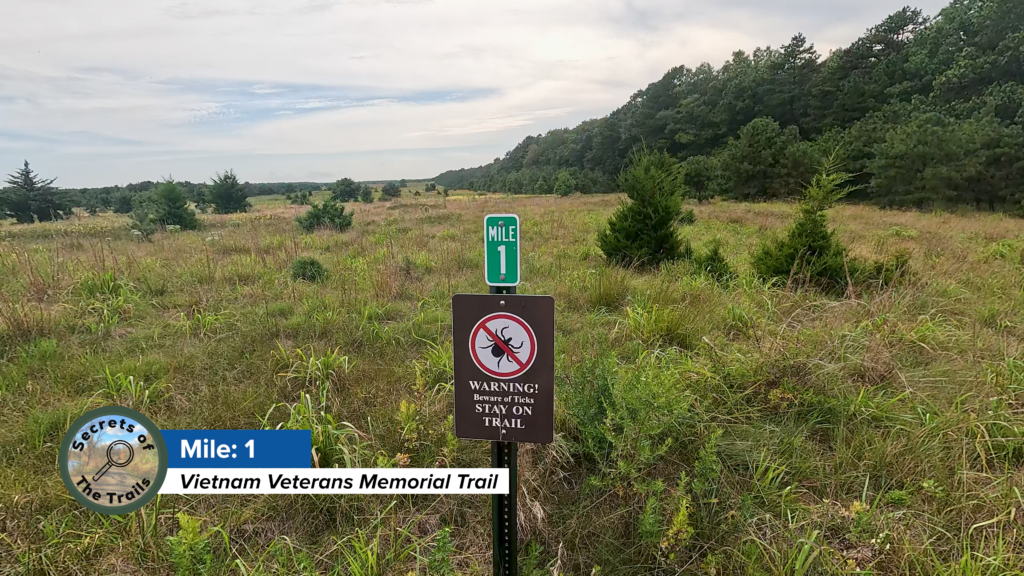
There are no specific “trail-branded” signs, however there are mile and half-mile markers all along the loop, mounted on metal poles parallel to the trail on the “inner” side of the trail surface.

Views
The most serene part of this whole trail is the vast amount of time that you’ll spend among the trees! This area is said to contain the largest remaining grassland on Long Island, that provides documented breeding and/or foraging habitats for a number of wildlife species, including the short-eared owl, the grasshopper sparrow, the common nighthawk, the tiger salamander and eastern box turtle among others.
Notwithstanding the fact that the trail parallels Middle Country Road (usually a busy road) along the northern portion of the loop, and River Road/Grumman Boulevard on the southern portion of the trail, I personally don’t think that these roads spoil the experience. Overall, this is a very peaceful trail to ride or walk!
Trailheads
Veterans Memorial Park
You’d be forgiven for thinking that Veterans Memorial Park is the only place to stage for this trail.
It’s easy to think that, given the sheer size of the parking lot alone – about 204 spaces with 8 designated handicapped spaces.


It’s also an actual park, with four baseball fields, a pickleball court, rest facilities, seating areas, pavilions, and a concession area that I’m guessing is used in-season for baseball games.
It also hosts the Peconic Hockey Foundation’s ice rink (that has its own parking area), and the Issac Dog Park, which was named after the beloved pet of the person who donated the money to build it.


The whole park is easily accessible from Middle Country Road (NY 25). Oh, and the trail mile markers start right here, too.
This is a great place to stage, because it is just so large. But it isn’t the only place that you can possibly stage.
Grumman Memorial Park
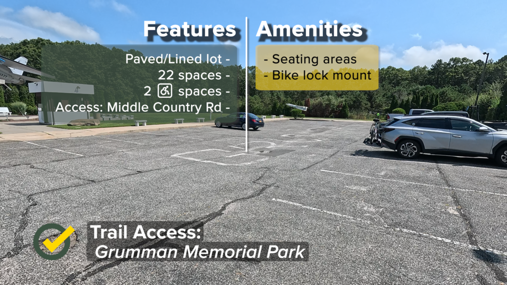
Grumman Memorial Park sits between Middle Country Road and the trail, approximately 1.5 miles east from Veterans Memorial Park.
At this site are 22 parking spaces, with two of them designated for handicapped access. The only cycling amenities at this trail access point are multiple benches and a bike rack.
Nonetheless, Grumman Memorial Park is a very interesting spot to visit, even if you’re not staging here – more on that below.
Henry Pfiefer Community Center
At just about mile 6.5 on the trail, and along Grumman Boulevard on the southern border of the property, sits the third trail access point that’s listed on TrailLink – at least there aren’t any signs around stating that trail access is prohibited here.

The Henry Pfeifer Community Center’s parking area sits inside the fence (the trail runs outside the perimeter fence at this point). The lot is paved but unlined, and there are no marked handicapped spaces in this area. I’m estimating it can hold about 15 vehicles.
Technically there are no amenities at this access point, but there probably are in the Community Center – whenever it may be open.
Riding The Trail: Trail Tips
Any Way You Want It
Since this is a loop trail, it should go without saying that you can start at any point and go either clockwise or counterclockwise around the trail.

However, the mile markers on this trail start at the Veterans Memorial Park lot connection with the Peconic Hockey Foundation’s lot (the driveway crosses over the trail), and counts in the clockwise direction.
But it’s still cool to go in either direction. Back in 2024, I cycled this trail both ways in succession.
Pay Respect

Along the first portion of the trail (from the start as described above, northward up toward Middle Country Road), you’ll see a number of small trees planted with memorial plaques dedicated to local servicepeople. I believe that these were just recently added, because they weren’t there when I visited in 2024.
I’d encourage you to stop for a minute, read them, and pay respect to those who served, and those who gave the ultimate sacrifice for their country.
The Kiosks At The Corners
If you look at the map of the trail (kindly provided to me by Riverhead Town – thanks!) and inset in the picture below, you’ll notice that the whole trail roughly has a rectangular shape.
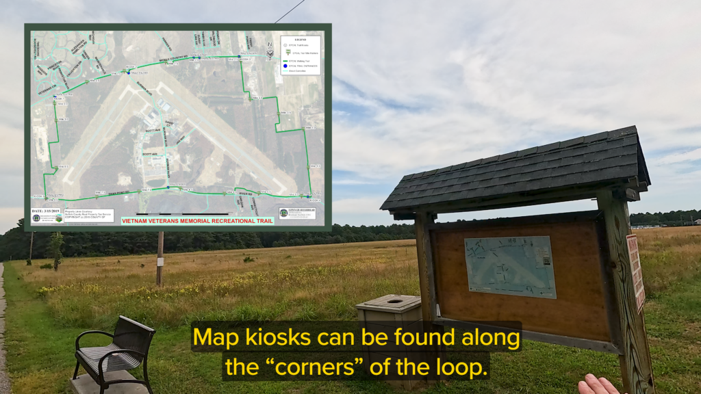
At the “corners” of this rough rectangle, you’ll encounter map kiosks – areas that include the kiosk itself, a bench, and a trash can. You’ll see these at various intervals along the trail, and particularly at the corners.
They’re nice spots to stop, take a break, and check the map along the way.
Traffic That You Don’t Have To Worry About
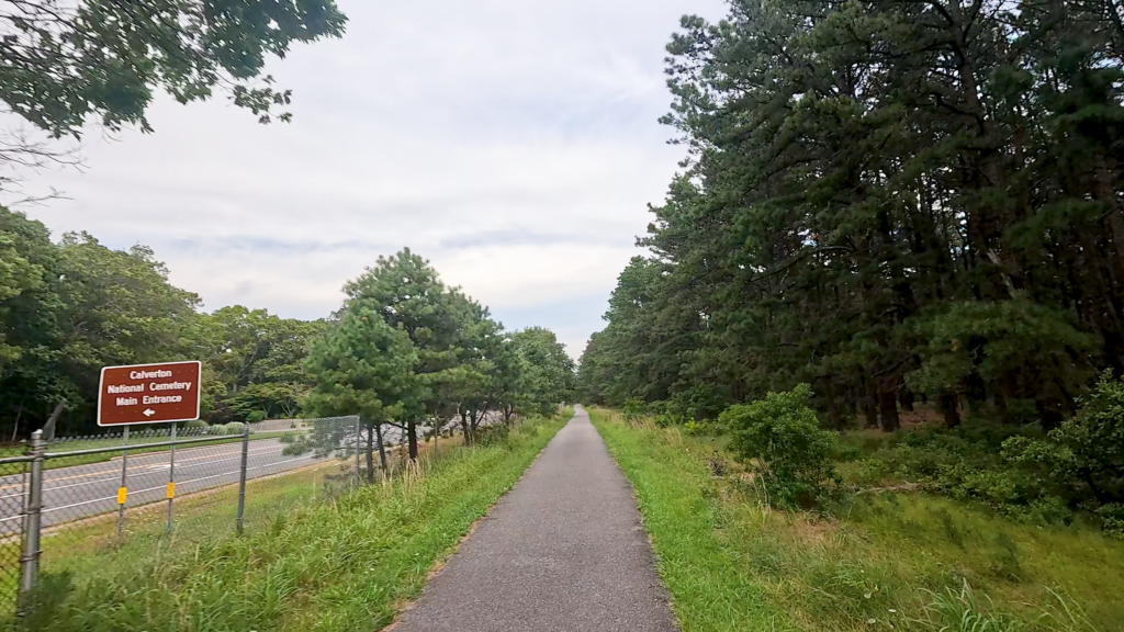
Going in the clockwise direction around the loop, the trail runs parallel to Middle Country Road (NY 25). It’s a major thoroughfare that connects a number of towns along the northern part of Long Island. Shortly after that first right-hand trail turn which leaves the Veterans Memorial Park property, you can see parts of the Calverton National Cemetery on the left along Middle Country Road.
Along the southern portion, the trail parallels River Road which turns into Grumman Boulevard. The traffic here isn’t quite as extensive as along Middle Country Road, though.

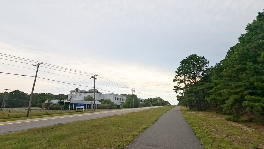
Both of these roads are separated from the trail by anywhere from 15 to 150 feet or more of grassy area, as well as the property’s perimeter fence (though the trail extends outside the perimeter fence along Grumman Boulevard for about a mile and a half before going back inside the fence).
So at least in this part of New York, you don’t have to worry about the traffic while you’re cycling!
The Enterprising Park
You’ll encounter the trail’s first intersection with Burman Boulevard, the main north-south thoroughfare through the Enterprise Park at Calverton, around the one-mile mark. The industrial park is managed by Riverhead Town.


Your best views of it are either from above (via Google Maps or Google Earth), directly from this intersection (I’ll call it the “northern intersection”), or the “southern intersection” of Burman Boulevard that intersects with Grumman Boulevard. You can also see a little bit of Enterprise Park if you look to the right along the trail after you pass the kiosk at the northern Burman Boulevard crossing.
Enterprise Park at Calverton still has the runways. However if you look from above on Google Earth or Google Maps, you’ll see large “X” marks painted on the runways, indicating that they’re not to be used for landing or takeoff.


Most sources that I’ve found, list the runways as “inactive” or “private use”, requiring permission from Riverhead Town to use them. The control tower that you can see from the north intersection of Burman Boulevard is apparently no longer in use.
Better Than Airwick
One of the nicest things about this loop trail is the nature that’s all around you. Even though there’s a business park in the middle of the property, you won’t often get the sense that there’s anything there as you’re riding or walking this trail, because of all the forested area between the Enterprise Park and the trail itself.
You’ll see this forested area on the right side of the trail, most of the way around the loop.


Much of the forested areas are pine stands. And, if you’re a fan of pine scent, this is just the trail for you! The fresh pine scent is definitely noticeable, especially along the eastern side of the loop. I personally think it’s better than Airwick or Glade, because it’s all natural.
The Mini Museum
About a mile and a half along the trail, the Grumman Memorial Park sits alongside a bend in the trail. There’s a gravel pathway that leads from the trail to the park, making for easy access.


This is a mini museum of sorts, with an actual A6-E and F-14 Tomcat situated on pedestals on either side of the parking area. I’m told that these are actual planes, just made “un-flyable.” They’re not prototypes or mock-ups.
You can also see on display, a Hughes AIM-54A Phoenix air-to-air missile that was carried by the F-14s.
There are a good number of seating areas, and lots of plaques and interpretive signage. While I didn’t include any of the interpretive signage on the accompanying video, I’ll include them here for your enjoyment (remember, all of the photos can be expanded by clicking on them)!


Just remember, Grumman Memorial Park is gated and closes at dusk.
The Incubator
Shortly before reaching mile two on the trail, there’s another crossover with a driveway. This driveway is for the Stony Brook University Incubator.


According to Stony Brook University’s website, this site is a “food business incubator”. It provides shared kitchens, storage, and separate rooms to support food startups on Long Island. It was conceived as an economic engine to enhance Eastern Long Island’s agricultural, aqua-cultural, and environmental industries.
Personally, I think it’s a great concept.
Sod and Wingnuts
Along the eastern portion of this trail, after leaving Middle Country Road behind and traversing four 90° turns in short succession, you’ll notice what looks like large piece of farmland on the left side of the trail, at the edge of which is a very small runway.
The farmland itself is owned by Delea Sod Farms. Interestingly, there are a good number of sod farm properties particularly on the northern portion of Long Island, and this is one of them.


At the edge of the sod farm, right at another 90° turn which leads the trail in a southerly direction, is a small airfield that’s labeled on Google Maps as being owned by “Wingnutz Squadron RC Flying Club”. I’m not sure if the club is still active, but the RC runway is still there. I’d appreciate if anyone knows one way or the other, please let me know!
The Plane In The Solar Farm

Just south of the RC airfield, on the left side of the trail you’ll see a rather large solar farm.
I’m not sure who owns the solar farm, or if it’s supplying power for the Enterprise Park (which would be my first guess).
However, in doing research for this post and the accompanying video, I came across a very interesting Google Earth image:


Okay, so while it looks like there’s a plane stuck in the middle of the solar farm, it’s actually an optical illusion. if you look closely, you can see the shadow of the plane a little bit further away from the plane itself, which indicates that this is clearly just a prop plane flying over that area on a sunny day, at the exact time that the satellite image was captured.
Feel free to copy these images and fool your friends.
Who’s Drew?
Shortly before the 5 mile marker, the trail turns westward (via another 90° turn), and runs parallel to River Road.
Just after the 5 mile marker, you’ll come to what has been considered a rather quirky feature on this trail.

Do a quick search on the Internet for “Drew’s Tower”, and you may come away with the impression that this is just some quirky platform built by people unknown. But there’s actually a really interesting story into the history of this tower.
Doing my due diligence for researching interesting places on the trails I feature, I spoke with one of the engineers at Riverhead Town’s engineering department, who was directly involved in the planning and creation of this trail.
It seems that when the original $800,000 grant was secured for building the rest of the trail to complete the loop, Riverhead Town was able to finish it with about $20,000 to spare. But the grant stipulated that all of the money was to be used, otherwise the entire grant would have to be returned.


Officials pondered over how to spend the remaining $20,000 and they came up with this publicly-accessible elevated observation tower, which affords a nice view of the area, including a bit of the eastern runway.

The sign on the tower isn’t the original one, though. According to the engineer I spoke with, the contractor made and mounted the original sign. But it shortly started to degrade.
The current sign was made and posted in its place by an anonymous donor – and to this day, Riverhead Town still doesn’t know who made and posted it. But I was told that it looked so much better than the original sign, that the Town government just kept it in place!

Oh, and the name of that Riverhead Town engineer who provided me with the history of this tower? His name is “Drew”… and that’s why it’s called “Drew’s Tower.”
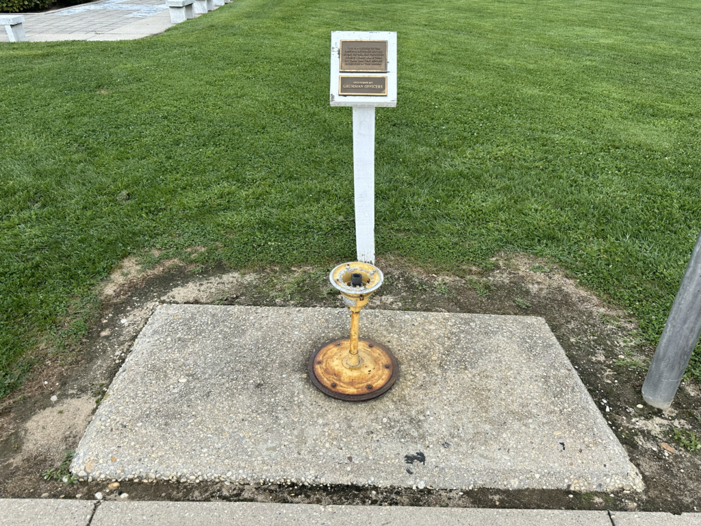
The Eagle Project Cemetery
Directly at the 5 1/2 mile marker, you’ll encounter the Wells Family Cemetery.
This was part of an Eagle Scout project by a young man in 2020. He has a laminated paper hanging on the sign, that provides a concise explanation of the area and his project.


This is nice shady spot to take a break because there are couple of benches here. So, stop for a minute and read up on the history of the Wells family and this cemetery.
Crossing The Tracks

Shortly before arriving by Mile 6 (the marker for mile 6 appears to be missing however), the trail runs parallel to a set of train tracks, and then turns left to cross over them.
According to sources, the rail line was originally used as a spur by Grumman to ship material in and out of the facility.

The first time I rode this trail several years ago, I assumed that the tracks were disused, however when I rode it again in 2024 (twice around, as I said earlier), I noticed that the first time I went around, there was nothing on the track. The second time I came around, there was a train car and what looked like an engine further down the track from the trail crossing.
I discovered later that Riverhead town rehabilitated the spur and it’s now being used by the New York and Atlantic Railway, that operates freight on the Long Island Railroad.
There are no lights or gates at this crossing, so please just look both ways before you cross over the tracks.
Going Outside The Fence
As the trail continues westward (again I’m considering my comments as riding the trail in a clockwise direction), you’ll come to another intersection with Burman Boulevard, the so-called “southern intersection”.

At this point the trail starts to run outside the perimeter fence for a couple of miles, but a wide grassy area safely separates the trail from Grumman Boulevard. Right along this first “outside the fence” portion, you can see part of the Swan Lake Golf Club on the other side of Grumman Boulevard. It’s a public course, so if you like cycling and golfing, maybe bring your clubs, ride the trail, then do 18 holes over there!


Just after the Henry Pfeifer Community Center trail access point, is a disused plant gate, after which you can see (roughly parallel to mile 7) two abandoned Grumman buildings on the opposite side of Grumman Boulevard. These are marked by a faded sign out front as buildings 8 and 78. They look to me like they may have been offices for draftsmen or engineers.
The Tempting Straightaway
After passing the abandoned Grumman buildings, the trail becomes rather flat and very straight for at least a half mile.
Now, I know this may seem like a tempting place to play speed demon. But just remember that walkers and joggers use this trail, too… some of them with small children or pets.

So, I’d strongly recommend that you stick to the widely-accepted “15 mph” bicycle speed limit here. You can always dream that you’re the next Tour de France winner… just don’t practice here.
Line Road, Part One
Around mile 7.5, the trail crests a bit of a mound and you’ll get a nice view of the grasslands around the western runway of the airpark.
Before reaching mile 8 however, is a maintenance gate that aligns with Line Road. According to Google Maps, it intersects with Grumman Boulevard across from the maintenance gate, and heads southward towards the hamlet area of Manorville.


However, closer inspection of the overhead satellite image seems to indicate that Line Road may at one time have extended northward, connecting to Middle Country Road. And that’s where the construction of the Enterprise Park property comes in.
It probably was a through road before the complex was constructed, but afterward was used as a private access way for service vehicles. It’s probably still used in this capacity since the portion of Line Road that crosses the extreme western tip of the western runway down to this maintenance gate isn’t paved but has a gravel overlay.
We’ll encounter Line Road again.
Scotty’s Got A Point(e) There
Mile 8 aligns with the 90° bend in the trail that goes back inside the perimeter fence. The trail passes through another peaceful portion of forested area on the western side of the loop.
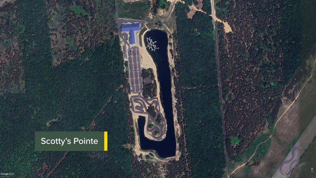

After a few more 90° bends through the trees. you’ll be able to spy on the left side of the trail, portions of Scotty’s Pointe, a large multi-purpose entertainment and amusement complex (it’s on private land and not part of the Enterprise Park complex).
Scotty’s Pointe features a variety of activities from water-sports on its own lake, as well as a Go-Kart course outside. Inside the large white building with a blue roof, you can find a restaurant, as well as laser-tag, rock-wall climbing, an arcade, and indoor surfing!
If you’re so minded then, you can ride or walk the trail a couple of times, and then hang out at Scotty’s Pointe!
Line Road, Part Two
The trail exits the forest at its intersection with Line Road… see, I told you we were going to talk about it again!
The trail uses Line Road for a short distance until its runs parallel to the parking lot of the Peconic Foundation Ice Rink. There, the trail continues beside the rink’s parking area until it reaches the crossover between the rink’s lot and the parking area for Veterans Memorial Park, at which point the loop completes.


However, all trail traffic at the intersection with Line Road is supposed to turn left back up to Veterans Memorial Park. There’s even a mounted sign in the middle of Line Road at this intersection that says “No Entry Beyond This Point”. But that apparently doesn’t stop people from riding or walking down Line Road toward the edge of the runway – even though you’re really not supposed to.
Trail Impression
The Vietnam Veterans Memorial Trail is a truly fantastic sub-10-mile fully-paved loop trail passing through cool sights and peaceful scenery.
I think it should be considered a welcome break from the urban sights and sounds of Western Long Island and New York City. It’s also right around some very interesting military, industrial, and space race history!
This is a great trail to ride multiple times in a row!


