The Great Allegheny Passage starts in Cumberland, Maryland and runs approximately 150 miles through fantastic scenic hills and valleys, to Pittsburgh, Pennsylvania.
In this post, we’re going to explore the trail segment from Whitsett to West Newton, PA.
History of the Trail
For a more detailed history of the Great Allegheny Passage, please see our overview.
History Along The Way
Whitsett
Nestled along the banks of the Youghiogheny River in Fayette County, the village of Whitsett is an example of a classic early 20th-century coal patch town.
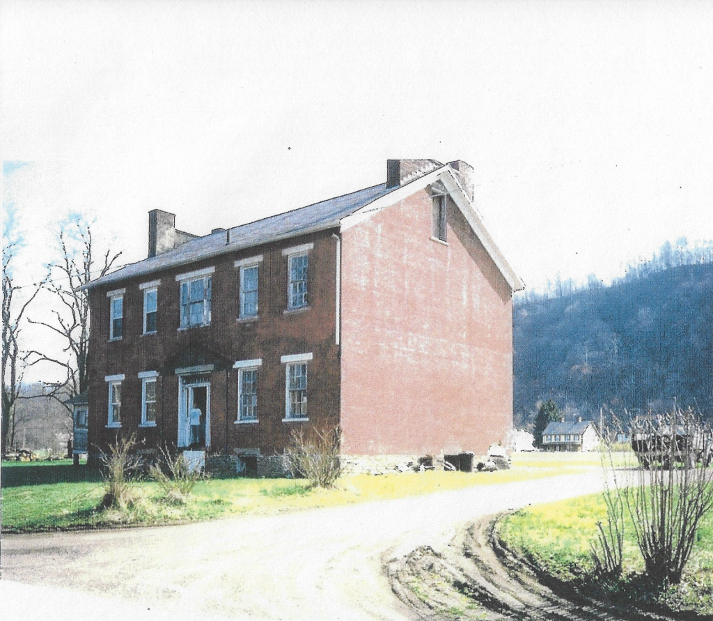
Whitsett was established by Ralph and Rachel Whitsett in 1845, and later built the original red brick house, which still stands today.
Due to the wealth of coal in the area, Whitsett developed into a “company town” of sorts for local mines, including Pittsburgh Coal Company-owned Banning Mines numbers 1 and 2, and the nearby Darr Mine, as well as the many coke ovens that dotted the hills around the town.
The coal mines and the coke ovens became central to the town’s existence, providing jobs – and a way of life – for generations of laborers, some immigrants from various European countries, and African-Americans, many who came from the South.
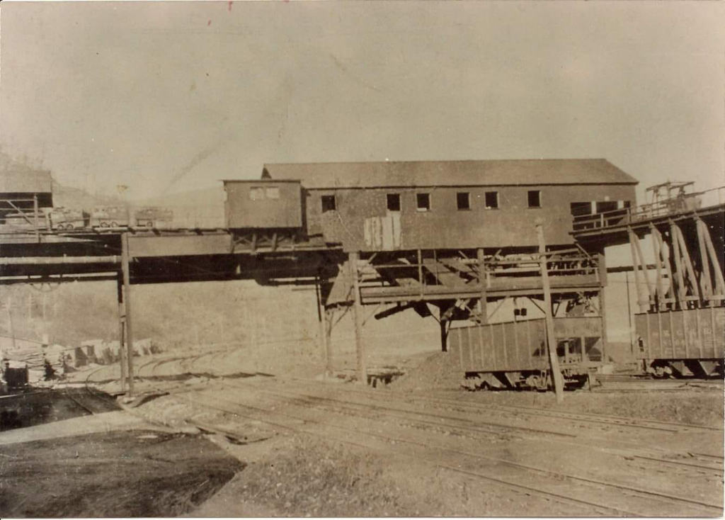
At its height, Whitsett housed hundreds of workers in company-built homes, with the Pittsburgh & Lake Erie Railroad cutting through its center. The Pittsburgh Coal Company opened Banning No. 2 Mine in 1902, and was at its height, said to be one of the most productive in the Youghiogheny River valley.
Coal from Banning No. 2 in Whitsett proper was carried via aerial “bucket lines” to Banning No. 1 (a couple of miles north) to be cleaned, while more aerial cable cars carried refuse to gob piles on both sides of the river.
The many coke ovens in the area, owned by both the Kaine And Wilkey Company, and the Anica Coke Works, regularly glowed red-hot, converting coal into coke, an essential fuel for steel production.
Today, Whitsett is a quiet community with far fewer residents than in its coal-mining heyday. And while the Banning mines have largely been torn down, remnants remain that can still be seen by those willing to look.
The layout of the town is largely the same, and many of its original home plots are still there, although renovated into single-family homes from their former semi-detached “twins” that were designed to accommodate two families.

in 1995, the Whitsett Historical District was added to the National Register of Historic Places. The former Banning No. 2 Mine property is now owned by famous mosaic artist Rachel Sager who created “The Ruins Project” from the remains of the mine’s outbuildings. These can be see today by appointment.


The Whitsett Historical Society keeps the town’s history alive through its very nice Facebook page.
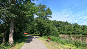
For travelers on the Great Allegheny Passage, Whitsett’s trailhead, sharing space with the Weiss Memorial Park, offers a welcoming rest spot along their journey.
Whitsett stands as a reminder of the industry that built a region—and the communities that gave it life.
Trail Details
Trail Length
This segment measures 10 miles point to point, from the Whitsett trailhead at GAP mile 104.1 to the West Newton trailhead at 114.1.
There are two notable trailheads within this segment – Smithton and Cedar Creek Park – which can be used as staging areas for walkers/hikers who want a shorter segment.
But the point-to-point distances between each trailhead within this larger segment are so short, it shouldn’t be difficult for most cyclists to do a full 10-mile point to point (20-mile out-and-back) between Whitsett and West Newton.
Trail Surface
The treadway surface is primarily crushed limestone, with an average width of 8-10 feet.
There are two short portions of the trail, namely around Sager Mosaics in Whitsett and through Van Meter, where the treadway width narrows to about 6 feet.
There are three road crossings on this segment, but the first one encountered with River Road in Whitsett is the only “through” road. You’ll cross over Flora Street in Van Meter, and Buddtown Road (about a mile before the West Newton trailhead), but these roads service the local homes in Van Meter and Buddtown so the traffic volume would be much lower.
Trail Signage
The Great Allegheny Passage utilizes standardized signage, as I mentioned more specifically in my overview of the trail [here].
Trail Views
The Youghiogheny River continues to be our companion for the entirety of this segment. We’re treated to some good views of the river, some islands in the river around Smithton, and a wide portion of the river at Cedar Creek Park.
Several streams cross the trail along the way, including the Banning #2 Run, Browneller Run, and the Cedar Creek Gorge.
This area is also chock full of coal and coke history, and we’ll pass by the remains of several coal mines, as well as markers commemorating the Darr Mine and Port Royal No. 2 Mine disasters.
We’ll also be treated to some interesting geologic formations in this segment.
Trailheads
Whitsett (GAP Mile 104.1)
The Whitsett trailhead shares its space with Weiss Memorial Park, that sits between the homes in the community and River Road, which itself is next to… well, the river!
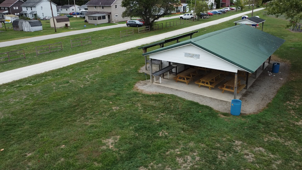
Weiss Memorial Park has two covered pavilions – one large and one small – with plenty of picnic-table seating, and a potable water source at the large pavilion. Also available trailside are two Porta-Potty stations and a bicycle repair station. At this time, there are no bike racks, but the pavilion columns and tables can easily be used for lock points.
The park itself features a basketball court, a small playground, and a baseball field.
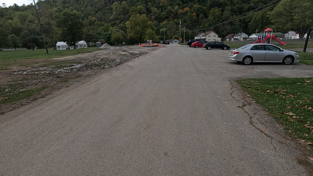
Parking for the park/trailhead is accessible from First Street. The lot facing the park has space for about 13 vehicles, with one of them designated as handicapped, and is paved but not lined A gravel lot is on the other side of the street that can hold an estimated 15 vehicles.
Smithton (GAP Mile 108.1)
Smithton is recognized by the Great Allegheny Passage as a trail town on their website, but it doesn’t appear in the TrailGuide and isn’t a part of the Progress Fund’s “Trail Town Program.”
Notwithstanding, Smithton is a good trail access spot, and I’ve known several local riders who use it as their staging point since it’s close by for them, rather than driving to a further trailhead.
The Smithton trailhead features a covered seating area and other benches, but no other amenities.
This trailhead is also a designated river access point for what’s called “Smithton Beach.” There is a well-marked trail to the beach from the trailside.
The gravel, unlined lot accessible from PA Route 981 (Smithton Road) can hold approximately 30 vehicles. Be aware however, that people will also park here for the river access.
Interestingly, a trek on your bike up the hill to Route 981 and across the Smithton Bridge will bring you into the town. “Float Smithton” is on the town-side of the Smithton Bridge to the left. It’s a river launch access for paddleboats and similar watercraft. Just beyond is the borough of Smithton itself which, as GAPTrail.org notes, is friendly to trail users.
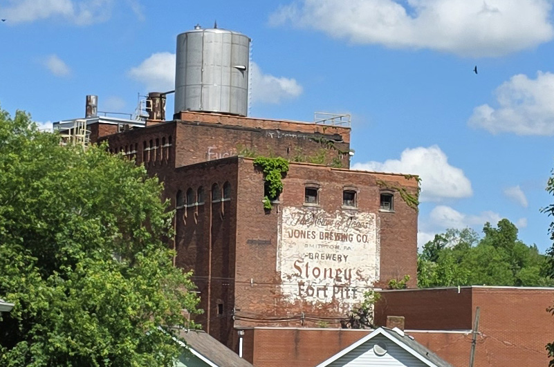
The longtime claim-to-fame for Smithton was the Jones Brewing Company and its signature “Stoney’s Beer” which is still made today (though just not in Smithton). Oh, and remember Shirley Jones, the famous actress and star of The Partridge Family TV show? Her grandfather started Jones Brewing Company.
Cedar Creek Park (GAP Mile 110.3)
The beautiful 479-acre Cedar Creek Park may not “have it all”, but it’s pretty darn close.
The park features over 20 pavilions within its sprawling acreage that stretches from the Youghiogheny River and all along the hillside. It also features the hiker-biker “Trekker Campground” at the southeastern end of the park between the trail and the river, featuring Adirondack-style shelters, potable water, and a toilet facility.

All along the approximate 7/10 mile stretch of the GAP that runs through Cedar Creek Park are multiple parking areas, all paved and lined, with multiple handicapped-designated spots, bike racks, full indoor restrooms, water, pavilions and benches, playgrounds, and a bike repair station.

Just before the trail leaves the park, there’s a two-mile out-and-back footpath through the Cedar Creek Gorge Interpretive Area. It’s a nice side trip along the trail, and has a bike rack nearby where you can lock up and check out the wooden suspension bridges, sheer cliff faces, cascading water, and the foundation of an abandoned saw mill along this walking trail.
This is such a cool spot and many trail riders use this as their staging area. I personally think that Cedar Creek Park should be more strongly recognized as a separate “trailhead”, but I do admit that this is unlikely to happen since the park isn’t actually a “town” – so I guess I’ll just be content to call it a trail access point.
Riding the Trail: Trail Tips
Sager Mosaics
Along the trail just before the River Road crossover, sits Sager Mosaics. It’s run by Rachel Sager, the daughter, granddaughter, and great-granddaughter of coal miners.

The building is a working mosaic art studio, selling handmade jewelry, mosaic art, GAP gifts, and Leona’s ice cream sandwiches.
Rachel also is the driving force being “The Ruins Project“, a long-term collaborative mosaic art installation adjacent to the studio. She conducts tours of the project, but only by appointment.
We’ll be passing more of her work further up the trail.
Sky Ferries

Shortly past the trail barriers out of Whitsett, you’ll see the “MINERS SKY FERRY” marker on the right side of the trail.
It’s sometimes listed as the “Jacobs Creek Sky Ferry” because many of the miners lived in the patch town of Jacobs Creek across the river.
Sky ferries like this one were used to shuttle six miners at a time from their homes across the river, to the mines on the opposite side.
We’re going to see a few more of these “sky ferry” sites in the segment from West Newton to Boston.
Banning Railroad Bridge
About a quarter mile before GAP Mile 106, shortly after crossing the wood bridge over Browneller Run, the Banning Railroad Bridge crosses over both the Yough and the trail.
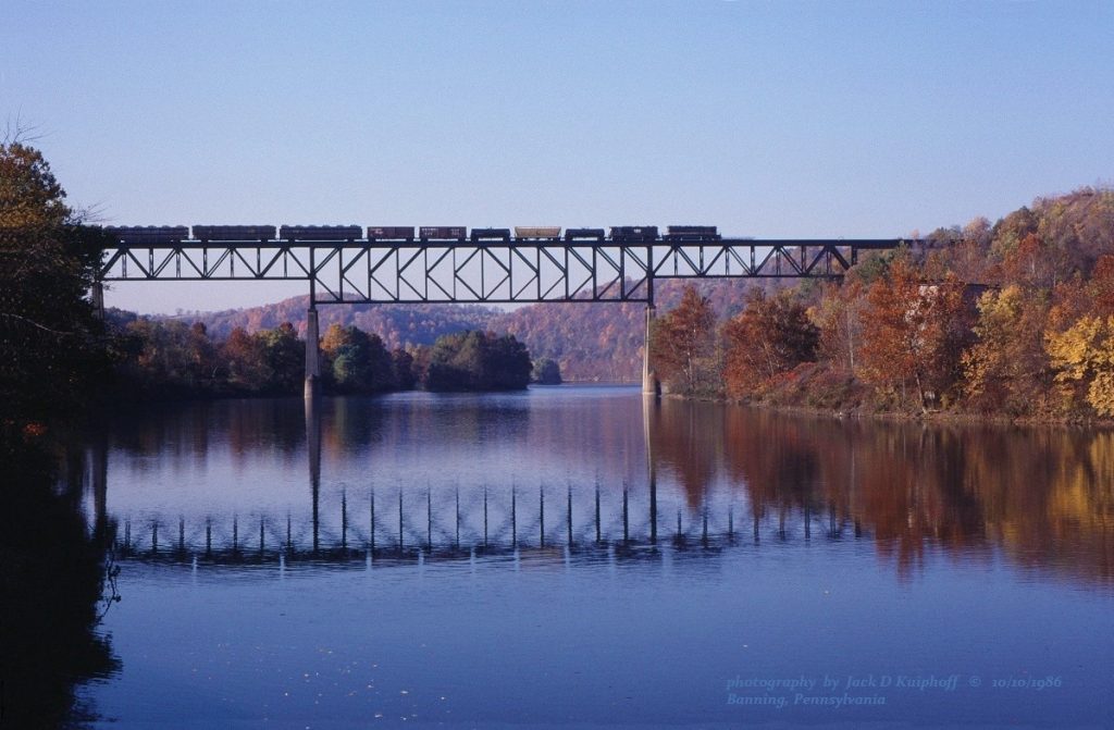
This “K-truss” design bridge is 160 feet high and 1,582 feet long. This “K-Truss” type bridge was built in 1930 by the American Bridge Company as part of a major railroad to be built in Pennsylvania.
Originally used by the Pittsburgh & West Virginia Railroad (now defunct), it still sees light use today by the Wheeling and Lake Erie Railway for freight traffic.
If you recall we saw the other end of this line at the old P & WV railroad bridge in Connellsville right at Yough River Park. According to the Wheeling & Lake Erie Railway’s track maps, the line ends in a junction with the CSX lines in Connellsville, which made the old P & WV bridge useless.
County Changes & Mine Disasters
Shortly past the Banning Railroad Bridge, we cross the Fayette/Westmoreland county line at GAP Mile 106.1.
Shortly after this point, we come across several coal mining features that are “don’t miss” if you’re into checking out the history of the trails that you ride or walk. These come within a short distance of each other.
Darr Mine Disaster Project Wall
We first encounter the Darr Mine Disaster Project. It was installed by local artist Rachel Sager that we mentioned earlier. It uses part of an old retaining wall for the Banning #1 Mine buildings.
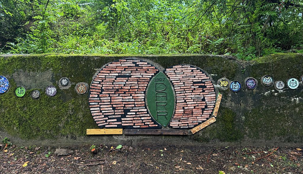
Each of the plaques is numbered and represents each of the 239 men who were lost on December 19, 1907 during the Darr Mine explosion that occurred a couple of miles just west of the project, in the old Darr mine. Check out the accompanying video on this segment to see the whole wall.
Banning #1
Just past the memorial wall, are the remains of Banning Number One. They have an interpretive sign here about the mine.

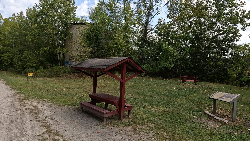

One of the silos and part of the coal cleaning plant are all that remain here of the old Banning Number One.
Darr Mine Disaster Marker
The other memorial to the Darr Mine disaster, erected by the Belle Vernon Rotary Club, sits on the left side of the trail just a few tenths of a mile away from the Banning #1 remnants.
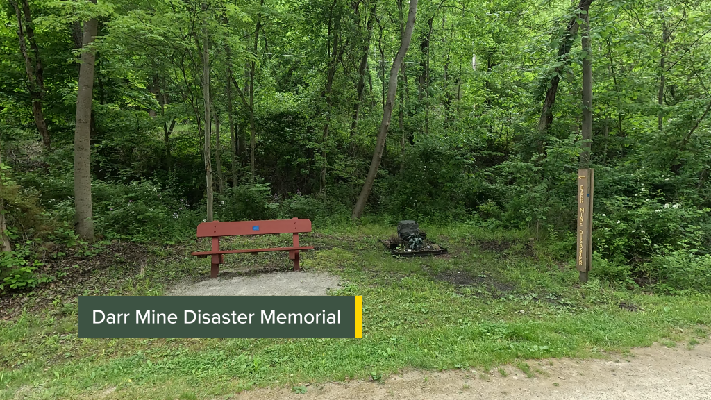

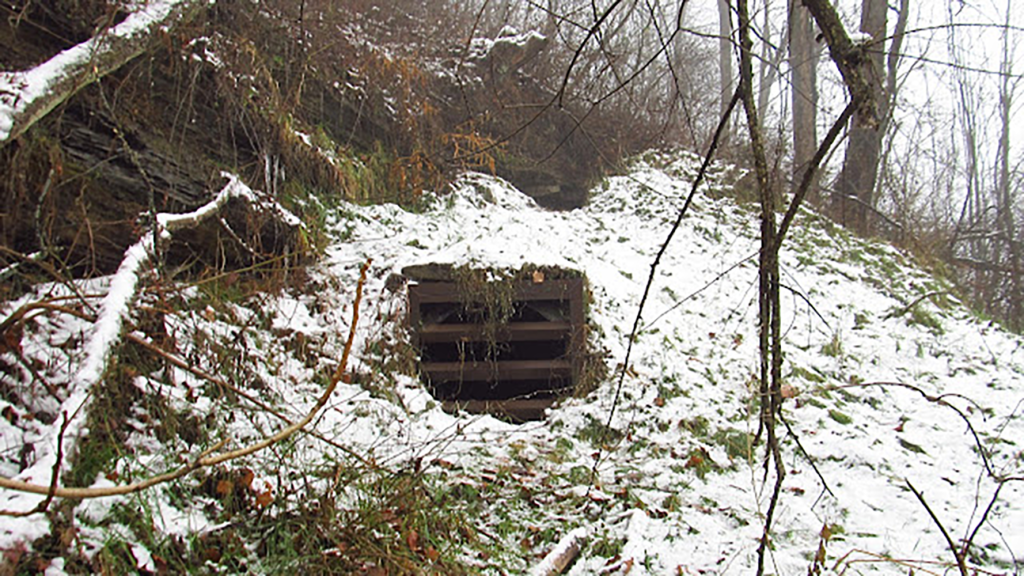
The mine entrance is said to be just beyond this marker. “Coke Oven Mike” has some good pictures of it on his blog.
Van Meter and the B&B On The GAP
Shortly after leaving the Darr Mine Disaster marker, we come into the little patch town of Van Meter, so named because John Van Meter once operated a ferry service around here in the 1790s.
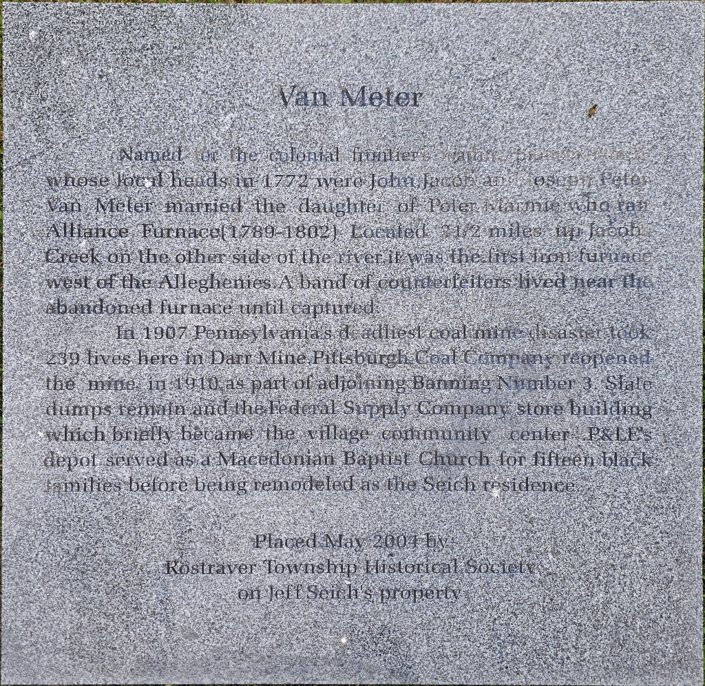
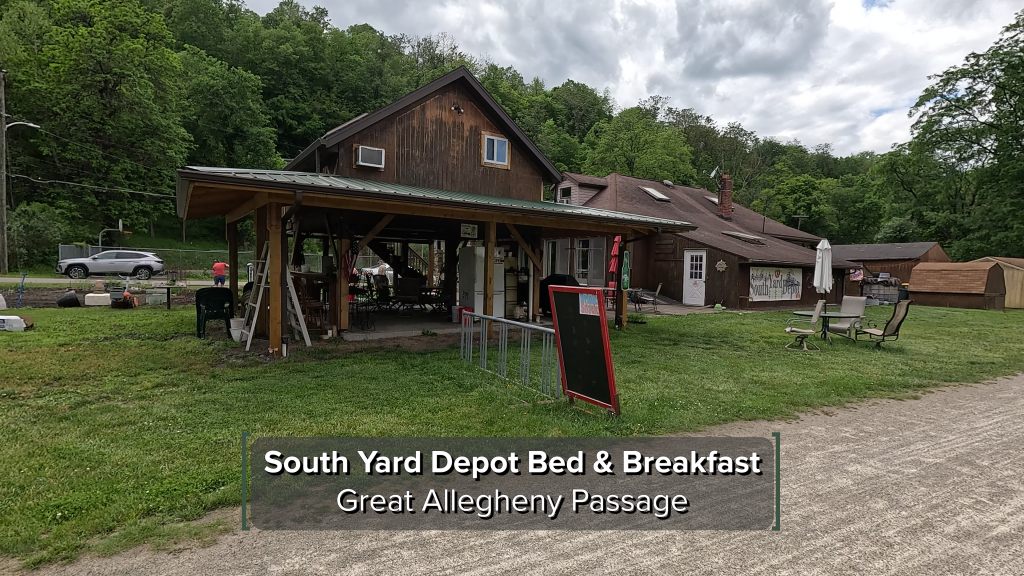
Right along the trail is the South Depot Bed and Breakfast. Now a private residence, the property used to be the Pittsburgh & Lake Erie Railroad’s Van Meter station (sometimes listed as “Jacobs Creek station”).
The private owners of this property run a small B&B in the loft you can see in the picture above, and they offer snacks and water to trail users, along with some bike racks and seating areas. It’s a nice spot to rest for a bit.
Banning #3
Just past Van Meter proper, you can see the old gob pile with a retaining wall. The old Banning #3 Mine was in this area.

You’ll note that there are a number of mines that were named Banning on this side of the river even though the village of Banning was on the opposite side of the river not too far away from Jacobs Creek. These were all named for Colonel A. R. Banning, who was a local coal and coke operator.
Thinking about these gob piles brings to mind a quote from Bill Metzger’s book The Great Allegheny Passage Companion where he said to “remember the equation: “IQ = 1/ rec hp”, which means intelligence is inversely proportional to recreational horse power”. I’ve seen a lot of ATVs riding a number of gob piles in various places over the years and honestly I don’t know if I would chance it.
Islands In The Stream, Part… OK, I Lost Count
Coming close to Smithton, roughly parallel to GAP Mile 107.8, you may at certain times of the year, be able to spy a number of islands in the river.

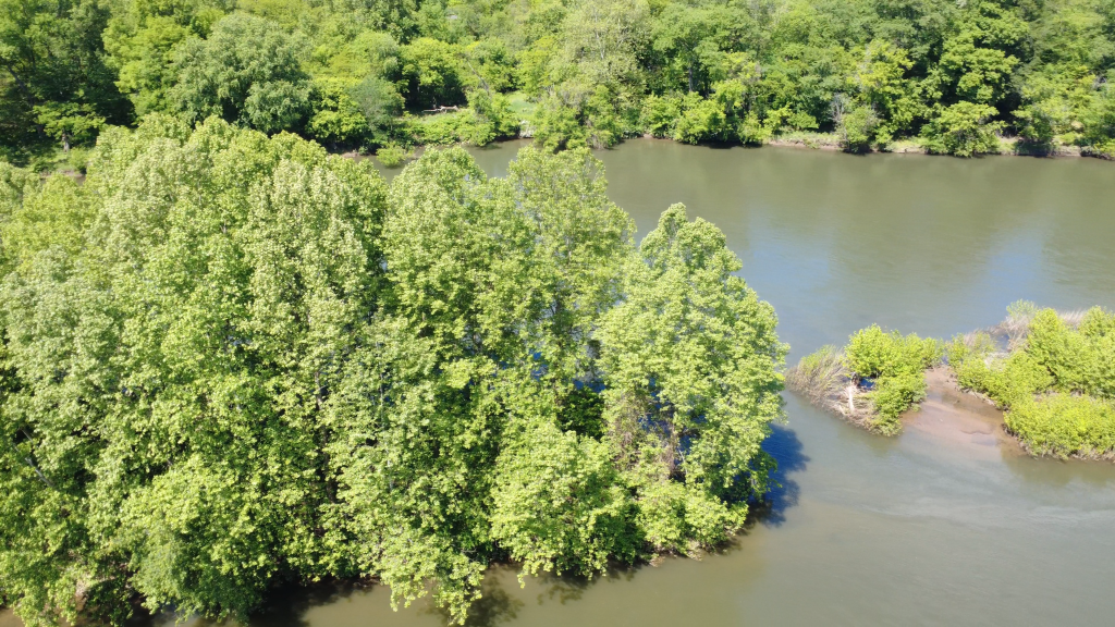
This is named the “McKivens Archipelago”. They’re a group of three islands that are close together and most easily seen on Google Maps or Google Earth (as above). But what the heck? I took out my drone during filming of the accompanying segment video and tried to get some shots as best I could.
ChatGPT says that these islets are popular with river kayaking enthusiasts because of the current changes through the archipelago, but apparently there’s no mention of why they’re called “McKivens” – presumably someone named McKivens in Smithton laid claim to them, but here’s a shout out to any locals – who the heck named this feature?
Another Mine Disaster… and What the Heck is a Tufa?
At around GAP Mile 109.5, we encounter a plaque to another mine disaster. This was the Port Royal #2 Mine disaster that occurred on June 10, 1901, when a buildup of methane gas caused an explosion and fire in the mine. Only 3 miners were said to be rescued.


Shortly past that Port Royal marker we see another geologic feature on the left side of the trail. It’s known as the “Port Royal Tufa.” But… what the heck is a “tufa”, you ask?
It’s essentially a stalactite like you’d see in a cave, but is on an outer surface of rocks. This formation is susceptible to damage according to geologists. So, while it’s nice to look at, it’s better off left untouched.
Mailboxes On The Rocks
I already mentioned about the Cedar Creek Gorge above, so we’re going right to another mini geology lesson around GAP Mile 111.5.


These cubby-hole looking formations are sometimes called mailbox formations, although the technical name is Liesegang structure, named after the German chemist who first observed them. To geologists, the honeycomb structure is made up primarily of iron concentrations in the walls of the honeycomb that are left behind as they were more resistant than the surrounding sandstone to water and air erosion.
However, just like the tufa formation we saw earlier, here’s another one of those formations where you can look but don’t touch.
The Yough Ness Monster
Shortly after passing GAP Mile 112, you’ll see something very curious along the right side of the trail.

Locals know this strange creature as the “Yough Ness Monster”, who’s said to roam the depths (depths?!) of the Youghiogheny River.
Interestingly enough, some years ago, I saw a cooler with a UPS sticker sitting next to the seat, prompting me to ask if the Monster was a UPS employee. I haven’t gotten a response from UPS management yet.
The Superfund Site Along The Yough
Shortly before we get to GAP Mile 113, we come across the remains of the Banning #4 mine.
On the left side of the trail was the whole complex. Looking at it from above on Google Earth, it was pretty large. Now, only a few building remnants remain.


According the Pennsylvania Department of Environmental Protection, this is a Superfund site and has a lot of hazardous waste over there… so I wouldn’t recommend exploring or ATV riding on the site.
On the right side is the active water treatment facility for the mine. I read online that the company that manages this site keeps the facility going in an effort to slowly detoxify the groundwater seeping from the mine.
The Budds
Right after GAP Mile 113, we encounter the area known as Buddtown. The most famous point here is the property and outdoor art exhibit known as the “Buddtown Knob.”
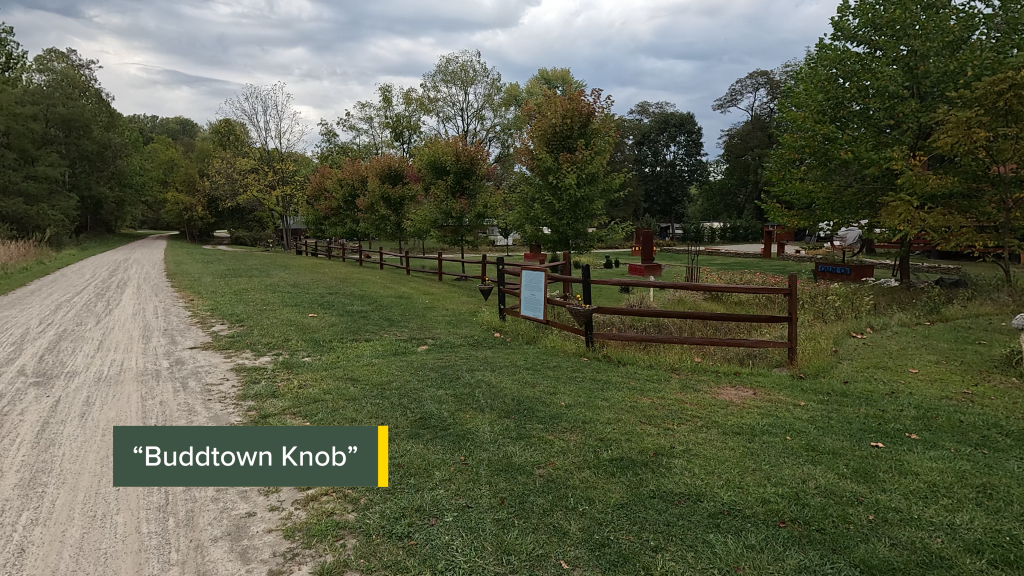


You can see the Buddtown Weather Rock here and the sign on the fence give us a bit of history about the Budds.
This area used to be the location of the P & L E yard office, where crews reported to work and got their assignments.
Trail Impression
The Whitsett to West Newton segment of the Great Allegheny Passage is an excellent 10-mile point-to-point ride that features a lot of coal mining history, along with many places to stage and take a break. This segment is easy to do for the novice cyclist, and is easily sectioned off into smaller portions for walkers/hikers who don’t want or don’t need to do a full 10-mile point to point hike. It’s another great segment of the GAP!