The Great Allegheny Passage starts in Cumberland, Maryland and runs approximately 150 miles through fantastic scenic hills and valleys, to Pittsburgh, Pennsylvania.
In this post, we’re going to explore the trail segment from Rockwood to Confluence, PA.
History of the Trail
For a more detailed history of the Great Allegheny Passage, please see our overview.
History Along The Way
Rockwood

Nestled in the heart of Somerset County, Rockwood, Pennsylvania, is a small town with a rich and fascinating history.
Originally known as Schaff’s Bridge and named after John Shaff, one of the early settlers, it also became known as Mineral Point due to the minerals found in the area.
The town began to take shape in the mid-1800s as more settlers arrived, drawn by the abundant natural resources and opportunities in the region.
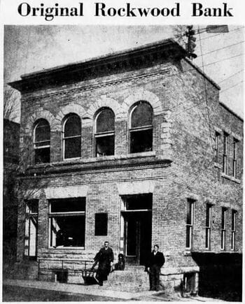
The area was laid out by Philip Wolfersberger in 1857, and soon various business were operating in the area, including a hotel, a blacksmith shop, a tannery, a wood mill, even an opera house. A post office was established, originally sharing space with the original Rockwood Bank and later moved to its own building.
Since there was already a Mineral Point in Cambria County, the name of Rockwood was settled upon and the town was officially incorporated in 1885.

The Pittsburgh and Connellsville Railroad extended through Rockwood in the mid-1800’s, and by 1871, the Somerset & Mineral Point Railroad connected this railroad with Somerset. The Western Maryland Railroad laid their tracks on the southern bank of the Casselman River, and these railroad connections brought more commerce and industry to this small community.
Soon after, the Baltimore & Ohio Railroad bought out the P&C, and these tracks remain active to this day, used by the CSX system (who eventually bought out the B&O) and by Amtrak.
Of course, as with many of these towns along the railroad lines, changing times meant changes in economic fortunes and industries. But Rockwood is one of a number of these rail towns that has definitely adapted with the times.
Today, Rockwood focuses on tourism and leisure activities, including hiking, biking, and water sports.

Rockwood is a major stop along the Great Allegheny Passage and is one of the few current trailheads that has a regularly staffed visitor’s center with friendly greeters able and willing to help and inform the users of the trail.
The Rockwood Area Historical Society’s Museum holds a variety of memorabilia to honor Rockwood’s past.
And you can still see trains running through Rockwood regularly on the active CSX, formerly B&O, rail line.
From its industrious beginnings to its modern-day charm, Rockwood, Pennsylvania, continues to be a place where history meets nature, offering a warm welcome to all who visit.
Trail Details
Trail Length
According to the Great Allegheny Passage Conservancy, the total distance from the Rockwood trailhead (at GAP mile 43.8) to the main trailhead at Confluence, is at total 17.8 miles.
This is one of the longer point-to-point segments of the Great Allegheny Passage. This segment has three inter-segment trail access points for those who don’t want to take on the entire segment at one time.
Trail Surface
The treadway surface is primarily crushed limestone, and there are some paved segments particularly around road crossings. Four bridges carry the trail across the Casselman River. Three of them have cast-concrete decking, and one has a wood-plank surface.
Trail Signage
The Great Allegheny Passage utilizes standardized signage, as I mentioned more specifically in my overview of the trail [here].
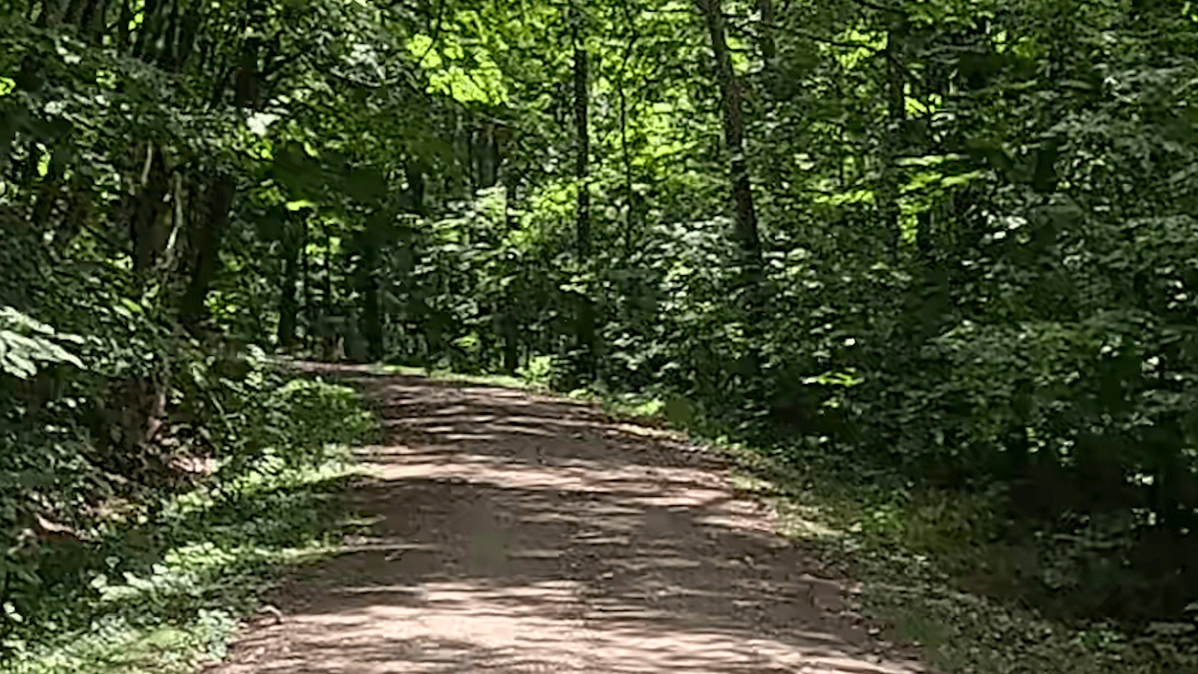
Trail Views
Going from Rockwood to Confluence gives the trail user a number of views of the Casselman River, and occasionally you may see some rafts or canoes traversing the river.
You’ll also be treated to the incredible Pinkerton Bridges with the tunnel between them.
This segment also proves the “all downhill from the Eastern Continental Divide” concept that we discussed in the Frostburg to Deal post, with a really cool average 0.5-2% downslope for most of the segment, in addition to some short segments that have a 2-3% downslope.

There are also some portions that run through narrow rock cuts, and others where you can see the forest floor on either side of the trail is much further below the trail itself, indicating areas where the Western Maryland Railroad builders likely built up the railbed.
Overall, the views along this segment make it a very peaceful ride!
Trailheads
Rockwood (GAP Mile 43.8)
Rockwood has what I consider technically two trail access points at the trailhead.
East Lot
The parking area that I like to call the “east lot” is on the eastern side of Rockdale Road. It’s an unlined gravel single-file lot with space for about 7 vehicles, and has a dedicated handicapped space available.

I think that some trail users would use this lot instead of the main lot, if they want to walk or bike eastward toward Garrett, and don’t want to have to cross Rockdale Road.
Since the now-closed “Husky Haven Campground” is just east of this parking area, it’s safe to assume that people parked here for the campground as well when it was open.
West Lot / Main Lot
I call the other parking area at this trailhead the “west” lot, since it’s on the western side of Rockdale Road.
This main lot is technically split across the trail itself. The larger portion holds about 17 vehicles, while the smaller portion can hold about 5-7 vehicles.

The lots themselves are unlined gravel surfaces and are arranged for single-file parking. The trail runs through the parking area, between the smaller and the larger lot, and through the trailhead, the trail itself is paved.
The “west lot” should also be considered the “main” lot for the trailhead, since the official GAP signage is here.
Also, all of the standard amenities we’ve come to expect from trailheads are also at the main lot, including several bike racks, two covered seating areas and a number of open benches, a permanent toilet building, a water fountain, and a bicycle repair station.
Trail Town Amenities
The Trail House, a combination bed and breakfast, bike shop, and snack shop sits on the western side of Rockdale Road right at the trailhead parking area. Just about 400 feet from the trailhead and on the eastern side of Rockdale Road, is another B&B, The Gingerbread House.


Traveling a bit north on Rockdale Road across the river, you can easily reach the main part of the town of Rockwood, where you can find Rock City Express (a full service convenience store), a Dollar General, and the Trailhead Brewing Company (a restaurant and bar). Turn east on Main Street for the Hostel on Main, the Rock City Cafe, as well as the Rockwood Historical Society.

Unfortunately for today’s trail users, one popular Rockwood business that’s still featured on many trail sites including the Trail Town Program’s website, and noted on many signs along the trail and elsewhere from Meyersdale to Ohiopyle, feature the “Rockwood Mill Shops and Opera House.”
But, according to their website that’s still live, the owners permanently closed this business in 2021. Fortunately though, the Mill Shops website is still live, because they have a good write up on the history of the building.
Markleton (GAP Mile 50.0)
The Markleton trail access is a few hundred feet north of the trail itself, accessible from Markleton School Road. To get to and from this trail access, you need to travel on Markleton School Road. Be cautious along this stretch that the trail crosses over however, because there is limited sight distance for vehicles using Markleton School Road approaching from the south.
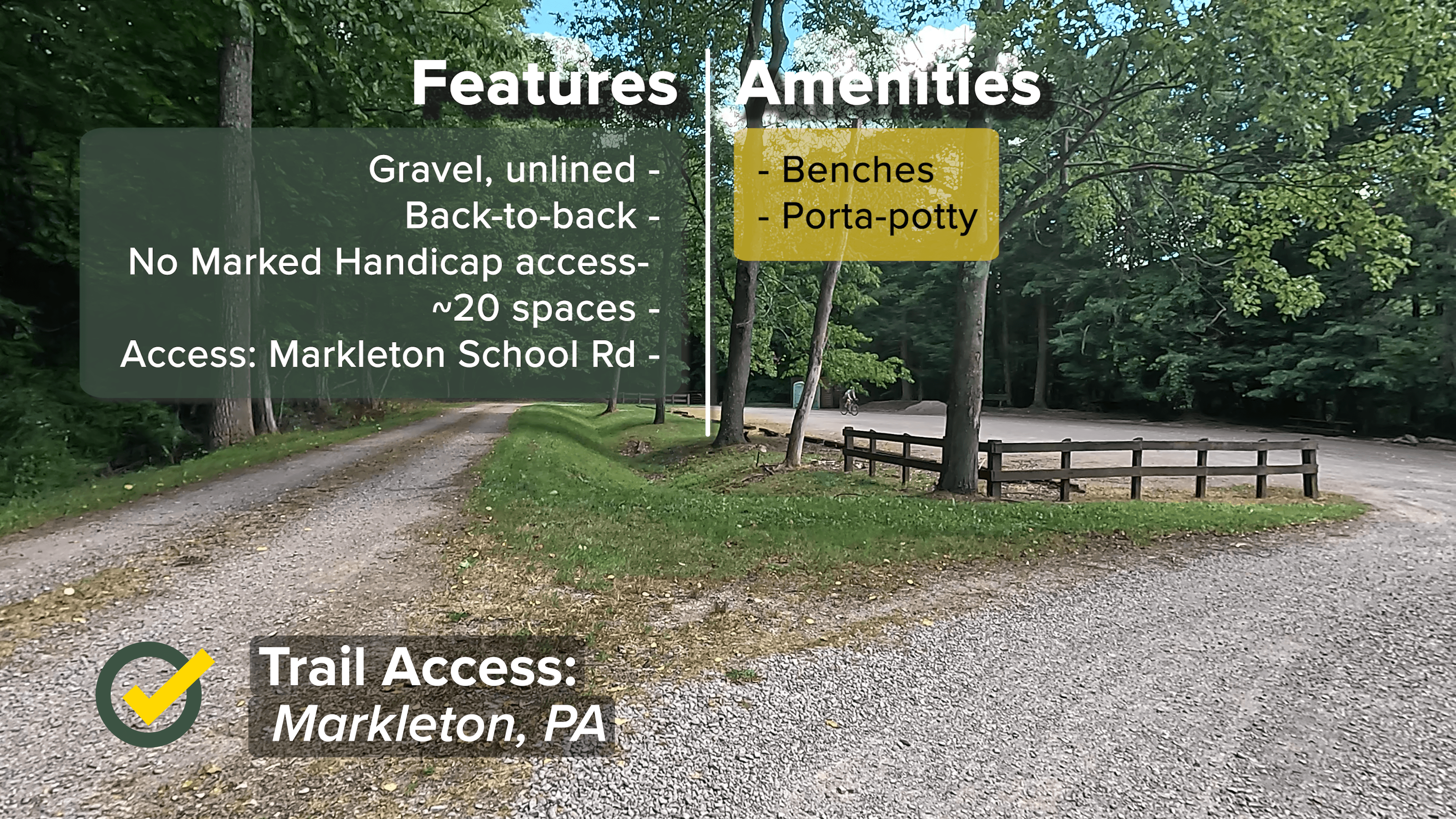
The trail access itself is a shared space for those wanting to use the GAP, and for boaters and other water sports enthusiasts who use this same parking area for Casselman River access.
The parking area is unlined gravel, with space for about 20 vehicles with parking arranged in a back-to-back format. There is a Porta-Potty and a bench along the side, but there aren’t any other visible amenities (as of this writing). Also, there don’t appear to be any dedicated handicapped spaces.
Fort Hill (GAP Mile 54.3)
The Fort Hill trail access point sits along a 180-degree bend in Fort Hill Road right where the GAP trail crosses this street. As such, there is definitely limited sight distance for vehicles coming from both directions, so I do advise caution crossing here.

The parking area sits on the western side of this bend, and is an unlined gravel lot that can fit about 7 vehicles. No amenities and no dedicated handicapped spaces exist at this trail access.
Harnedsville/Lower Turkeyfoot Township (GAP Mile 59.0)
The Harnedsville trail access point is a single-file unlined gravel lot that sits on the southern side of Hogback Road in Lower Turkeyfoot Township just outside of Confluence.

It has space for about 5-6 vehicles with no dedicated handicapped spaces. At this access point, a bench and a porta-potty are available.
It’s also right next to the Lower Confluence Casselman River Bridge, which many people use for photo ops of the quiet river below.
Riding the Trail: Trail Tips
It’s (Mostly) All Downhill From Here
Remember back when we were riding from Frostburg to Deal, passing over the Eastern Continental Divide, and I said that from that highest point on the entire Great Allegheny Passage it was “all downhill from here”?

This segment definitely highlights that concept. The entire ride from Rockwood to near the Harnedsville trail access is at least a gentle downslope, but there are some portions – especially after the Fort Hill trail access – where the downslope approaches about 3%. None of these are long enough or problematic enough to cause difficulty if you’re going uphill from Confluence to Rockwood, in my opinion.
Codelines

If you’re observant, you’ll see what looks like old telephone or telegraph poles every so often, along the right side of the trail from just outside Rockwood to near Harnedsville.
Wondering what they were, I did a bit of research and discovered that these were poles for “codelines.”
Someone posted on Reddit some time ago, and gave a very clear explanation of that they were for. Obviously the codelines were needed for communication, power, and signaling prior to the advent of satellite and other wireless communication capabilities.

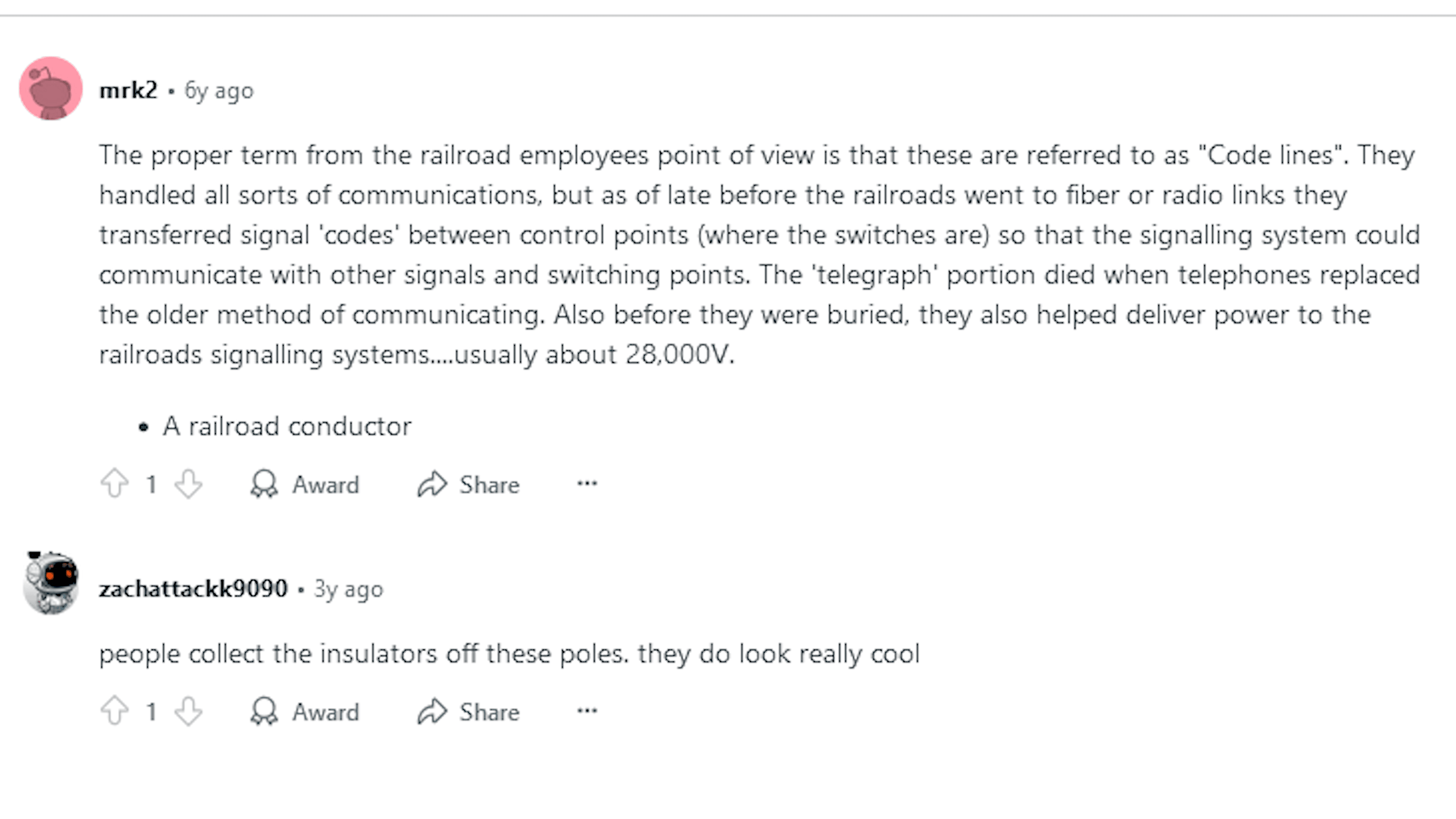
While it’s certain that a number of these old codeline poles were either deliberately removed or degraded and fell onto the forest floor – since you’d expect to see one spaced evenly apart along the length of the rail bed – you can still see some of them around. Some of them still have wires attached.
Spotty Cells
I’ve said it before, and hopefully you don’t mind if it bears repeating.
Some of the more rural portions of the GAP have spotty cell service. We saw the biggest lack of cell service (so far) around the Deal trailhead.

Here’s another portion where cell service is either very poor or cuts out completely. From about 4-5 miles out of Rockwood, cell service becomes sporadic, and – regardless of your carrier – you may not pick up strong cell signals until GAP mile 58, a couple of miles past the Fort Hill trail access point.
If you use a trail app such as AllTrails to track your rides, just make sure you download your maps for offline use before you ride this segment of the GAP.
“Tuberculis”
OK, that’s an inside joke that you would have gotten if you watched the companion video first.
In the Markleton area, the story goes that there once was a private health sanatorium that was used by the US Army for soldiers and other personnel, including those who had contracted tuberculosis. This is what it apparently looked like, according to this photo courtesy of the Meyersdale Public Library project:

Its heyday appears, according to the Asylum Project’s webpage, to have been most active in the early part of the 20th century.
Today, I’m told that no vestiges of the hospital remain on the site. But, although information available notes that it was on the northern bank of the Casselman River, I’ve never been able to accurately pinpoint where it was, and if there’s anything else on or around the original property.
If anyone knows and can lead me to coordinates on Google Maps or other atlas systems, let me know!
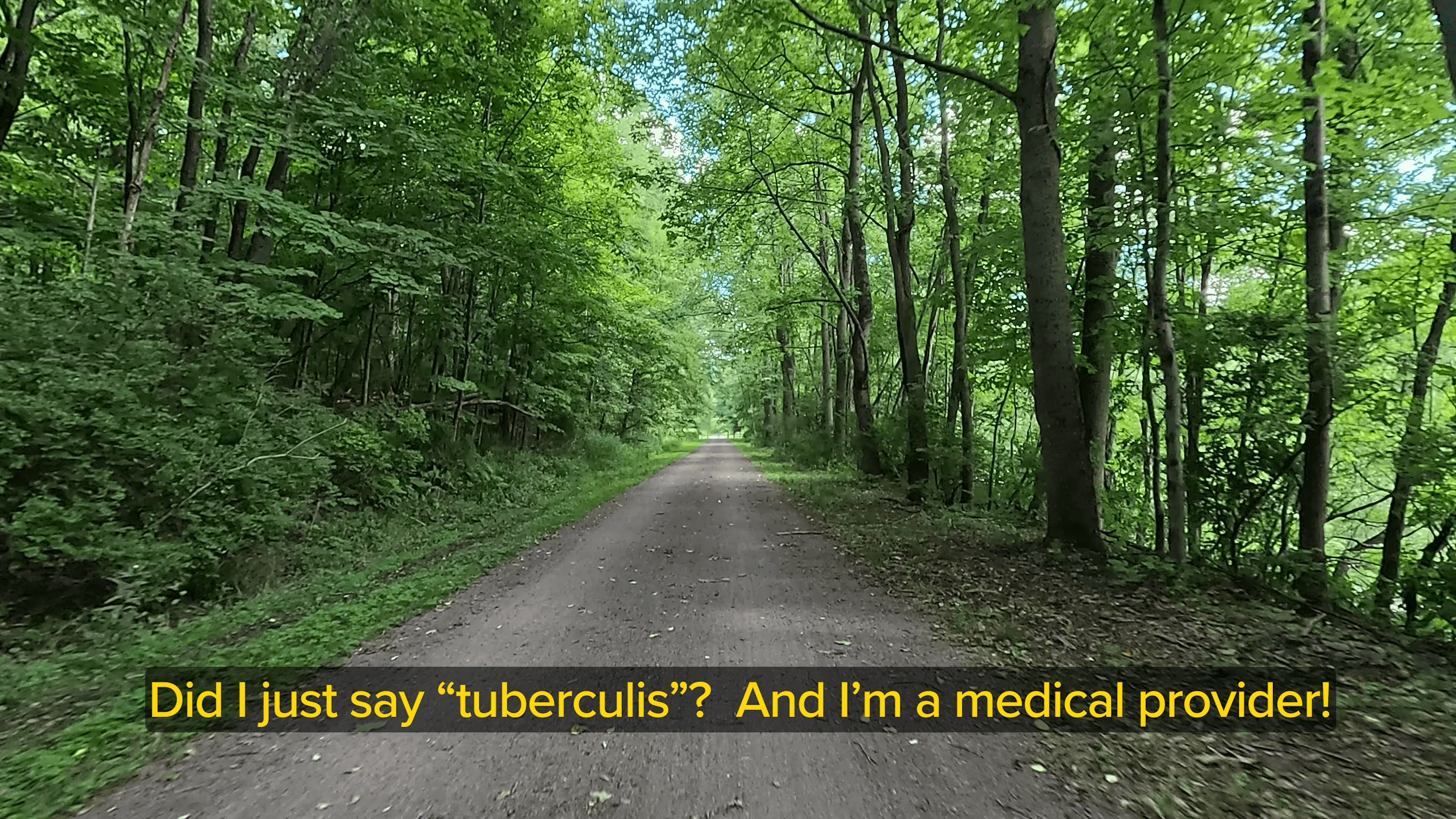
Oh, as for “tuberculis”, I misspoke when I was filming this segment, and said “tuberculis” instead of “tuberculosis”. I certainly know better, since I’m a medical provider in my “day job”, but when I was editing the video I laughed so hard at my mistake, I just kept it in the video – check it out if you haven’t done so already!
Pinkerton

No, not that Pinkerton.
This Pinkerton.

Around GAP Mile 52, is another of those “oh wow, look at that” features on the Great Allegheny Passage. This is the area of the Pinkerton Tunnel and the High and Low bridges.
The land feature here is often called the “Pinkerton Horn.” It’s a natural peninsula, where the Casselman River flows around the horn, passing about 30 feet under the 242-foot-long Pinkerton Low Bridge, then returns on the other side of the horn and flows about 100 feet under the 543-foot-long Pinkerton High Bridge, with both bridges carrying the trail across the river.
Between the two bridges, is the Pinkerton Tunnel, an 849-foot-long tunnel that cuts through the Pinkerton Horn.

It was originally built for the Western Maryland Railroad in 1911. But after the railway was abandoned, the tunnel fell into considerable disrepair.

Around the horn is the “Pinkerton Bypass”, a near 1.5 mile trail that, as the name implies, bypasses the tunnel completely. It was originally used by the B&O railroad as a “shoofly” around their tunnel (the B&O, now CSX, railroad is on the opposite side of the river from the GAP trail) after their tunnel was consumed by a fire in 1879 and required repairs.
According to official Great Allegheny Passage history, this bypass was used by the GAP trail to bypass the Pinkerton Tunnel which was unusable and rehabilitation plans were mired in all kinds of red tape.
But finally – and thankfully – the red tape was cut, deals were made, funds were raised, and the Pinkerton Tunnel was completely rehabilitated and officially opened in 2015 as the official path of the Great Allegheny Passage between the two bridges.

The tunnel has a unique corrugated steel liner shell all the way through this wide tunnel. However, it’s not lighted at all, so even though it’s rather short as far as rail tunnels go, I still recommend that you remove any sunglasses or helmet visors, and use your headlights as well.
The bridges were originally a wood-plank surface (that you can see on some photos on GAPhistory.org), but thanks to the great folks at the Somerset County Parks & Trails department, I was able to confirm with them that the re-decking was completed in 2023 with a sturdier and easier-to-ride cast-concrete surface.


A Sidenote:
While doing the filming for the YouTube video to accompany this post, I did have a video riding the bypass. However, it was done while I was still experimenting with the best settings to use on my GoPro cameras. In post-production, I noticed that the footage was basically unusable. I will, sometime early in the 2025 cycling season, head back up to this trail segment and re-shoot the bypass. Once completed, that video will be made available as a “Trail Highlight” (video short) on the Secrets Of The Trails YouTube channel.
Heading Downhill
As mentioned earlier, certainly most of this segment is downhill to a certain extent. Most of the slope is anywhere from 0.5 – 2%, and sometimes barely noticeable.

Just after GAP Mile 57 though, there’s a portion of the trail about perhaps a third of a mile in length, that I measured with my pocket inclinometer to be about 3%. While riding this segment, I didn’t have to pedal at all, and my Aventon e-bike’s torque sensor didn’t kick in the motor either.
That said, I’d really love to hear from any professional surveyors who have some time on their hands, who can check out the incline on these portions of the trail (including the segments I’ve previously posted about) to check my estimates.
That First Step Is a Doozy
There’s a portion of this segment around GAP Mile 57 (as well as some others) where you’ll see wood fencing erected along either the river side, or both sides, of the trail for a stretch.
At certain times of the year (again depending on the degree of foliage) you can see why: the trail is very close to a steep drop-off to the river below.

While it should go without saying that you’re safest sticking to the trail itself, these small portions really emphasize that fact. So, watch that first step off the trail…
Over The River…
The GAP crosses the Casselman River a total of four times in this segment.
The first two crossovers are at the Pinkerton Horn, with the Low and High Bridges. There are two other crossovers, around GAP Miles 59 and 61.
The Lower Confluence Casselman River Bridge, also referred to as the “Harnedsville Bridge”, sits next to GAP Mile 59, and is a 302-foot-long deck-plate girder bridge that has an interesting feature as it was built with a three-degree rightward curve. Its decking was resurfaced from wood-plank to cast concrete in 2023, along with the Pinkerton bridges.


The 404-foot-long Confluence Casselman Bridge, is the only remaining wood-deck bridge on this segment of the trail. In a recent communication with the Parks & Trails Director for Somerset County, she noted that as of this writing (early 2025), proposals are underway to finance the re-decking of this bridge. I honestly believe it will come to fruition, and would be a welcome relief especially for trail riders – and our teeth!
…and Through The Woods – with Deer!
Obviously we know that a lot of the Great Allegheny Passage runs through forested areas.
But did you know that deer use the trail, too?
OK, so it’s a really bad shot. But on my final filming day for the companion video, I just happened upon three deer on the trail in front of me, about a mile or so before Harnedsville Bridge, actually running on the trail!

Unfortunately, I was too far away for my GoPro cameras (I was only using 2 at that time) to get a really good shot of them, but if you watch the video you can see three of them running for a bit on the trail, then jumping into the woods on the left. I passed two cyclists who were stopped, and were also checking out this cool happening!


So, I guess it’s OK for us to share the trail with the deer! This was such an unexpected and awesome sight, that notwithstanding the less-than-optimal quality of the zoomed-in video (even though I consistently shoot in 60fps 4K resolution), I just had to include this!
Islands In The Stream, Part II
In the Garrett to Rockwood segment, I mentioned the presence of a few small islands in the Casselman River that can most easily be seen on Google Maps, though at certain times of the year (due to foliage or lack thereof), you can also easily glimpse them during your ride or hike.


Right at Markleton, you can see two islands in the river. Also, between GAP Mile 57 and 59, you can see three others. These are definitely larger than the ones seen between Garrett and Rockwood, but from all appearances there’s completely uninhabited and unused – but they do look cool!
You Lucky Dog
OK, let’s get one thing straight. I don’t get any money for doing this, and certainly my YouTube channel doesn’t have enough subscribers (yet) to allow for monetization (help me out there, folks, please subscribe!). I do this for the love of cycling, and as a kind of extension of my old career as a nurse educator.
So, I never expect that any business or entity that I feature here or on YouTube will expect me to ask for any compensation or “goodies” whenever I mention them. To me, the fact that such businesses along the trail do a great job of taking care of us trail users is compensation enough!
To that end, I have no problem mentioning what I think is a great end to this segment ride: the Lucky Dog Cafe on River Road, the access road for the Confluence trailhead parking area.


I’ve stopped there several times on my rides, and from personal experience, I think their food and their coffees are very good.

I think it’s a great place to stop and unwind after you’ve mounted your bikes back on your car racks and are ready to head home. Stop and have a sandwich, or check out the other great fare that they have.
Oh, and as the name implies, dogs ARE welcome.
(Ok guys, there’s your free advert – now maybe a free coffee? LOL, just kidding!)
Trail Impression
The Roickwood to Confluence segment is one of the longest point-to-point segments along the Great Allegheny Passage, but it’s packed with peaceful forest and river views, spectacular selfie-worthy bridges, and is “book-ended” by two very cyclist and hiker-friendly trailhead towns. Whichever trailhead you decide to use for a staging point for an out-and-back, the uphill ride from Confluence to Rockwood is not hard to do!
Acknowledgments
For the companion video, I featured a screenshot from two YouTube videos during the town history section. Although I included the links to these two videos as “card” overlays in YouTube, I also would like to include the links here:
“Casselman River kayaking” by Christopher Kirstein
“CSX Autorack Train Moves Through Rockwood, PA” by BaltimoreAndOhioRR
Also, my great thanks to the GAP History Project and the Somerset County Parks & Trails Department for their assistance with information for both this post and the companion video. It’s not any sort of “schmoozing” to say that I definitely appreciate all of your help and information!
Also, I’d like to think that I speak for all of the users of the GAP as well as the other trails in Somerset County, when I offer my profound appreciation for all of the great work done by everyone at the GAP History Project, the Great Allegheny Passage Conservancy, and Somerset County Parks & Trails in not only maintaining these trails and keeping them safe, but also for the continuous advocacy for recreational trails!


