The Great Allegheny passage starts in Cumberland, Maryland and runs approximately 150 miles through fantastic scenic hills and valleys, to Pittsburgh, Pennsylvania.
In this post, we’re going to explore the trail segment from Frostburg, Maryland, to Deal, Pennsylvania.
History of the Trail
For a more detailed history of the Great Allegheny Passage, please see our overview.
History Along The Way
Frostburg
Frostburg is a city in western Maryland about 8 miles due west of Cumberland. Like Cumberland, Frostburg has a history deeply rooted in the industrial development and transportation networks of the Appalachian region.

Frostburg was founded in the early 19th century as a small settlement known as Mount Pleasant. Its growth was closely tied to the region’s coal mining industry. The discovery of coal deposits in the surrounding mountains spurred economic development and attracted settlers to the area.
The town’s name was changed to Frostburg in 1820 in honor of Meshach Frost, a prominent landowner and businessman. Frostburg quickly became a center for coal mining and related industries, such as coke production and glass manufacturing.
The expansion of the Baltimore and Ohio (B&O) Railroad into the region in the mid-19th century further fueled Frostburg’s growth, providing a crucial transportation link for moving coal and other goods to markets in the East.
Throughout the 19th and early 20th centuries, Frostburg thrived as a bustling industrial town, with coal mining serving as the primary economic engine. The town’s population grew as immigrants, primarily from Europe, came to work in the mines and build new lives in America.
But Frostburg’s prosperity wasn’t without its challenges. The coal mining industry was fraught with dangers, including cave-ins, explosions, and health hazards such as black lung disease. Labor disputes and strikes weren’t uncommon as workers sought better wages and working conditions.

By the mid-20th century, Frostburg, like many coal towns in Appalachia, began to decline as changes in the energy industry and advancements in technology led to a shift away from coal. Many mines closed, and the town’s population started to dwindle as residents sought opportunities elsewhere.

Despite these challenges, Frostburg has worked to preserve its rich history and heritage. Today, the town is known for its charming downtown area, historic architecture, and cultural attractions. Frostburg State University, founded in 1898 as a teacher’s college, is a prominent institution in the town, contributing to its cultural and educational vibrancy.
Frostburg also benefits from its location amid the scenic beauty of the Appalachian Mountains. As a major trailhead for the Great Allegheny Passage, Frostburg continues to attract outdoor enthusiasts who come to hike, bike, and explore the nearby trails and recreational areas, and often partake of Frostburg’s off-trail amenities.

In recent years, Frostburg has focused on revitalization efforts to stimulate economic growth and enhance the quality of life for residents. These efforts include downtown redevelopment projects, cultural initiatives, and initiatives to promote tourism and outdoor recreation. While Frostburg’s industrial heyday may be in the past, the town remains a resilient community with a proud heritage and a bright future.
Trail Details
Trail Length
Starting at the trailhead itself (see the previous post on the Cumberland to Frostburg segment about the “two faces” of the Frostburg Trailhead) to the Deal trailhead, this segment measures at 9.2 miles point to point.
Trail Surface
Starting at the trailside parking trailhead in Frostburg, the treadway is crushed limestone. The width is an average 10 feet, but there is a significant portion of the trail from north of its crossover of Mt Savage Road NW, that the treadway width is almost double its standard width. However, this additional width on the “right” or eastern side of the trail appears much less groomed and in spots is depressed several inches from the western, more groomed side of the trail. I haven’t come across exactly why this is, however if I had to hazard a guess, I’d say the extra width is used by locals with ATVs (which I’ve seen several times) or maintenance vehicle use so as not to impede riders or hikers on the trail.
The surface of the trail through the Borden Tunnel is paved, and the motion-sensing lights were installed in the tunnel some years ago.
Trail Signage

The Great Allegheny Passage utilizes standardized signage, as I mentioned more specifically in my overview of the trail that you can find here.
As mentioned in the previous entry, Frostburg “technically” has two trailheads, one at trailside and the other at the Frostburg train station which is accessible on the trail via a half-mile uphill switchback. Also available atop the switchback is the Miners’ Park, the Thrasher Carriage Museum, Trail Inn, and Tracks & Yaks. Historical buildings, Frostburg State University, and many other points of interest, coffee shops and eateries, are a bit more of a ride up Depot Terrace (Depot Street) from the train station.
Trail Views
Traveling toward the Deal trailhead, spectacular views await you atop Big Savage Mountain. It’s also cool to be able to stand on the Eastern Continental Divide and say “I’m standing on the highest point on the GAP!”
Trailheads
Frostburg (GAP Mile 15.5)
I probably beat the uniqueness of this trailhead to death in the last post, so I’m going to just reiterate here that the trailside markers should be considered the technical trailhead itself, since all of the amenities are here: covered seating area, bike repair station, water fountain, Porta-Potty, and plenty of parking.

In fact, by best calculations, the trailside parking area can accommodate a total of 22 vehicles at least (including handicapped) with the parking areas laid out in a back-to-back fashion with the two handicapped spaces separated from the larger parking area, and placed literally next to the trail.
At trailside, there are no e-bike charging stations yet, but I have spied some outlets at the Trail Inn and Tracks & Yaks – so if you need a top-up and you ask really nicely, they may offer you some juice.
Given that the GAP Conservancy has arranged charging ports at Canal Place in Cumberland and downtown Meyersdale, it wouldn’t surprise me if we see this option popping up soon at other major trailheads such as Frostburg.
Deal (GAP Mile 24.6)
The Deal trailhead, in my opinion, doesn’t get the justice it deserves from the GAPtrail.org website. If you use their interactive planner to map a route from points west to points east and vice-versa, the Deal trailhead isn’t even an option. But I think it should be.
At 24.6 miles in from the start of the Great Allegheny Passage at Canal Place, the Deal trailhead is a large gravel parking lot with able to accommodate approximately 35 vehicles, judging by the number of concrete parking blocks arranged in the lot. The trailhead also has a bicycle repair station with bike lock posts, a Porta-Potty, and a covered seating area. It has no water supply.

Also, this area of the trail for several miles east and west of the Deal trailhead, has very spotty – and sometimes nonexistent – cell phone service.
Riding the Trail: Trail Tips
The Ride Uphill
While most of the trail from just north of the Frostburg trailhead to the Mason-Dixon line is an estimated 1.5% upslope, the first hill on this segment is about a quarter-mile or less after leaving the trailhead. It doesn’t last long, just about another quarter-mile. The trail then downslopes until it passes over Mt Savage Road NW, then turns to an uninterrupted 1.5% (and sometimes a bit more) upslope all of the way up to the Big Savage Tunnel.
Borden Tunnel (GAP Mile 17.9, Segment mile 2.3)
After passing the 2 mile mark on this segment, the Borden Tunnel awaits.

The Borden Tunnel is a 957-foot long former railroad tunnel which, like the Brush Tunnel earlier on the trail, was constructed in 1911 by the Western Maryland Railway as part of its expansion from Cumberland, MD to Connellsville, PA. It’s a semicircular arch tunnel featuring rectangular cement portals with corbeled edges. It was repurposed as part of the Great Allegheny Passage construction after being abandoned in the 1970’s.
The tunnel is wide, and the treadway is paved. The treadway at the entrance and exit of the tunnel is paved with paving stones. It also has motion-detection lighting that was installed a couple of years ago.
A word of caution however when going through the tunnel: the motion detection is delayed, and often the lights turn on when you’re almost past each light. So it’s a good idea to make sure you have a bright headlight available on your bike.
The Line (Mason-Dixon Line, GAP Mile 20.5)
You know, history books are full of information about the Mason-Dixon line and its significance not only to the states which borders it defines, but also to US history.
Apparently it all started when, and 1700s, the family of William Penn (founder of Pennsylvania) and the descendants of Charles Calvert (proprietor of Maryland) quarreled over the boundary line between the 2 territories. British astronomer Charles Mason and surveyor Jeremiah Dixon solved the quarrel by surveying the line between 1763 and 1767.

Their work, taking from 1763 to 1767 to complete, required precise and time-consuming measurements but were made using relatively simple tools. These included a zenith sector, a navigator’s quadrant, a direction transit, an astronomical clock, and 16-1/2 foot wooden rods. Mason, Dixon, and their team marked out the legal boundary between the two territories on foot and on horseback through the rugged wilderness, placing stones to mark each mile of the boundary, and specially carved “crown stones” every 5 miles, that contained the family crests for both the Penns and the Calverts.
Of course, anyone with a rudimentary grasp of American history will know that the Mason-Dixon line also served (and to some, still does) serve as a cultural demarcation line between the northern and southern United States. Never was this truer than during and after the US Civil War. I’d like to think that our culture has moved on since those dark days.
Today, the best of the heritage of the Mason-Dixon Line is celebrated with landmark replicas and interpretive signage where the GAP trail intersects the famous line. There’s a replica of the surveyors’ 66-foot measurement chains crossing the trail surface, an obelisk honoring the Penn and Calvert families whose antagonistic boundary dispute precipitated Mason and Dixon’s survey work, and a set of engraved granite blocks – all perfect for your photo op.
OK… you talked me into it…

The View from the Top (Big Savage Vista, GAP Mile 21.7)
No matter the season or time of day, there’s nothing that quite makes you say “wow, just look at that” on this segment like the “Big Savage Vista”. Sitting about 3/10th of a mile from the eastern end of the Big Savage Tunnel, the views are striking.
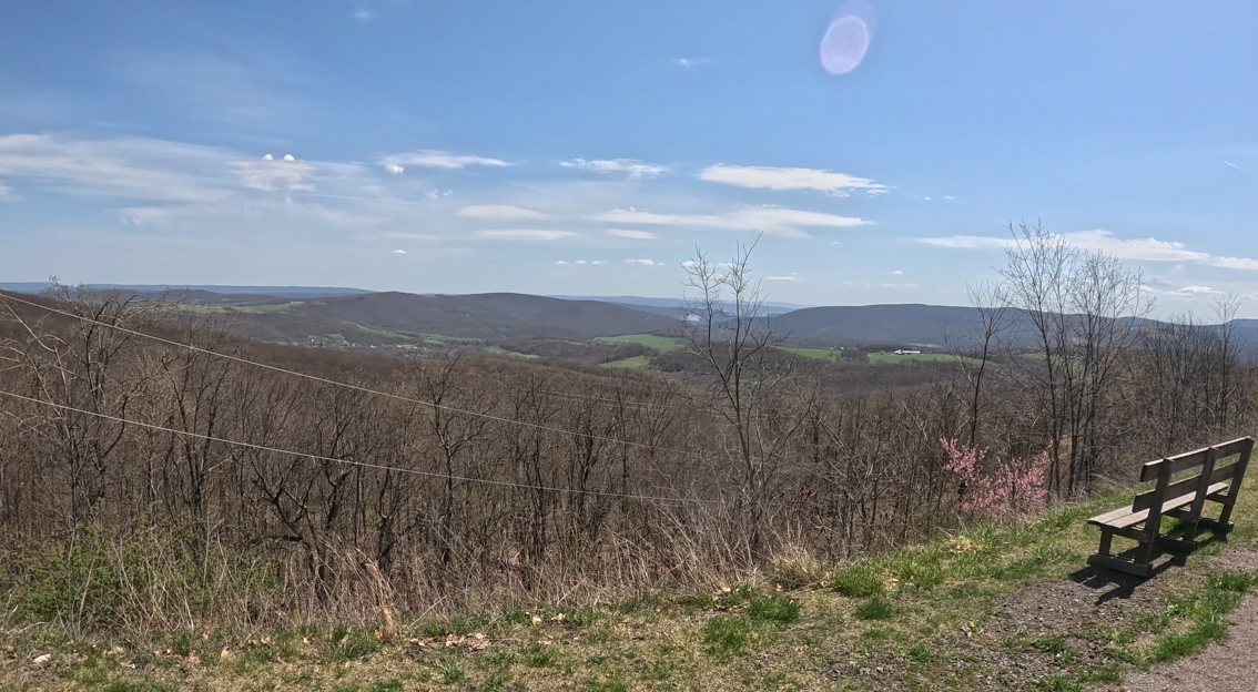
The Vista offers a fantastic view of two states (Pennsylvania and Maryland). The GAPTrail.org website claims that one can see four states from this vantage point, but I surmise that you’d really have to know what you’re looking at since a part of West Virginia is just south of Frostburg, but the northernmost part of Virginia may be harder to identify.
Interestingly, as high as it feels that you are at the Vista, you’re only about 2300 feet or so above sea level. There’s a bit more to go.
Very close by are benches overlooking the vista itself, and on the other side of the trail is a covered seating area with bike stands, a bike repair station, and a Porta-Potty. There is also a cement pad on the other side of trail from the overlook, which I assumed would be for emergency access, since it appears perhaps just big enough to let a small helicopter land – but I’ve never been able to verify its exact purpose. I’d welcome comments if anyone knows for sure.
The BIG Tunnel (GAP Mile 22)
Completed by the Western Maryland Railway in 1912 to carry its expansion line from Cumberland to Connellsville through Big Savage Mountain, the Big Savage Tunnel is a marvel to behold and to ride or walk through. Lengthwise, it’s been quoted by GAPTrail.org as 3,291 feet long, though Wikipedia quotes its length as 3,295 feet, and other sources claim other numbers between those two.

Big Savage Tunnel is named for surveyor and inventor Thomas Savage who you may remember from the last post as the man after whom the Maryland town of Mount Savage was named. According to records, he and his surveying party were stranded on the mountain in the winter of 1736. And according to legend, he offered himself up as food to save the rest of the party from starvation. However, it’s said that a rescue team showed up, saving Savage’s life. In honor of his heroics, the mountain, the town, and eventually the tunnel were named after him.
It’s also noted that during the construction of the tunnel, the railroad had some problems with soft mud and sand encountered during construction on the western side of the tunnel. Since conventional methods didn’t seem to help, the railroad brought in “air locks” of the type used during New York City subway construction. Though the tunnel was completed in 1912, the soft material surrounding the dig continued to plague the railway and required continual repairs to the tunnel.

After this tunnel, along with the others on the railroad right of way, were abandoned in the mid-1970’s, the tunnel deteriorated. As part of efforts to construct the Great Allegheny Passage in the 1990’s, the GAP Conservancy garnered support for the tunnel restoration. Work included extensive rock-bolting of the original liner and the installation of a new liner with an aggressive drainage system to help minimize the freeze/thaw conditions that were known to have regularly damaged the tunnel in the past.
Today, Big Savage Tunnel is lighted – although due to its length, reflectors and good head and tail lights are strongly recommended. It also has custom arched portal doors on both ends.
The tunnel remains open from April through November, conditions permitting. It is closed during winter months to protect its inner concrete liner from damage, and trail users from any falling debris. There are no alternative routes to use from one end to the other by bicycle or foot during the winter. If you’re intending to use the trail between November and April, I strongly recommend checking out the GAPTrail.org website where they post updates when the tunnel opens and closes.
The Divide (Eastern Continental Divide, GAP Mile 23.7)
Remember when I said that there’s a bit more to go with elevation on the trail? Well, here it is.

The Eastern Continental Divide, at 2,392 feet above sea level, is literally the highest point along the entire Great Allegheny Passage. To coin a phrase, either way you travel on the GAP, it’s “all downhill from here.”
The Eastern Continental Divide is a hydrographic divide that separates the Chesapeake Bay and Mississippi River/Gulf of Mexico watersheds. It runs from just south of western New York State through Florida.

While it may be a superfluous fact, the northern terminus of the Eastern Continental Divide originates at the Eastern Triple Divide, intersecting with the St Lawrence Divide on Triple Divide Peak, a mountain in Potter County, Pennsylvania, which is about 10 miles south of the New York-Pennsylvania border.
The trail along the divide is paved. It runs through an underpass below McKenzie Hollow Road which can be used to access the Deal trailhead from Frostburg and points south.
The built-up underpass walls are lines with murals depicting the Western Maryland Railway on the eastern side and the Pittsburgh & Lake Erie Railroad on the western side.
If you’re traveling with a group, don’t pass this literal “high point” by. Take a pic with your feet straddling the yellow line painted across the trail that marks the divide!
Trail Impression
The Frostburg to Deal segment of the Great Allegheny Passage is a sub-10-mile point to point ride that is spectacular in its views, and quite easy to ride, despite its almost 2% upslope for most of the segment.
As with the Cumberland to Frostburg segment, your personal physical condition will dictate to you how you approach this segment – but if you’re able to do this trek, even as an out-and-back, it’s very much worth it – especially if you stage at Frostburg – because the downhill run from Big Savage Tunnel is FUN!

