The Great Allegheny Passage starts in Cumberland, Maryland and runs approximately 150 miles through fantastic scenic hills and valleys, to Pittsburgh, Pennsylvania.
In this post, we’re going to explore the trail segment from Confluence to Ohiopyle, PA and Ohiopyle State Park.
History of the Trail
For a more detailed history of the Great Allegheny Passage, please see our overview.
History Along The Way
Confluence
Confluence, Pennsylvania, is a small town in Somerset County with a rich history rooted in transportation, industry, and outdoor recreation.
The town gets its name from the meeting of three waterways: the Casselman River, Laurel Hill Creek, and the Youghiogheny River.

It’s said that young George Washington explored the region in 1754 during his days as a surveyor, and noted that the three bodies of water appeared to resemble a turkey foot. It’s probably why this area is known as the Turkeyfoot Valley.
The area was originally inhabited by Native American tribes who used the rivers for travel and trade. When European settlers arrived in the mid-18th century they were drawn by the region’s abundant natural resources and waterways, and the opportunity for greater settlement, farming, and transportation.

During the 19th century, Confluence became an important transportation hub. The newly constructed National Road was only a few miles south, and the Baltimore & Ohio Railroad laid its tracks along the northern and eastern banks of the Casselman and Youghiogheny Rivers, both of which contributed to the town’s growth.

Lumber, coal, and agricultural goods were transported via rail and river, supporting the local economy. Sawmills processing vast amounts of lumber were floated down the Youghiogheny River to Pittsburgh and beyond. Small-scale industries, including gristmills and tanneries, also emerged, serving the needs of the growing population.
The borough of Confluence was officially incorporated in 1873.
But with all its charms, Confluence still couldn’t escape the ravages of nature. A devastating flood in 1936, one that reportedly impacted many communities downstream from Confluence, led to the construction of the Youghiogheny Dam in the early 1940’s by the US Army Corps of Engineers.

This was around the same time that the US was ramping up production for munitions during World War II first for the Allies and also later for our own needs. The city of Pittsburgh with its vast steel industry – vital to the war effort – was downstream of the Youghiogheny. It was feared that another devastating flood could also overflow the Monongahela River, since the Youghiogheny flows into it, and cause significant damage to steel production.
The building of the dam was a transformational moment for Confluence. The resulting reservoir turned the area into an extremely popular destination for boating, fishing, and camping.
In the latter half of the 20th century, the decline of the railroad and timber industries led to economic shifts. However, Confluence found new life in its burgeoning outdoor recreation and tourism activities.

Today, Confluence is best known as a key stop along the Great Allegheny Passage, and is widely regarded as the GAP’s first major “trail town” since the first completed segment of what became the Great Allegheny Passage lay between Confluence and Ohiopyle State Park.
Cyclists, hikers, and other outdoor enthusiasts now flock to the town to enjoy its scenic beauty and amenities, as well as other nearby attractions, such as Kentuck Knob and Fallingwater, two of Frank Lloyd Wright’s masterpieces in the area. Businesses catering to tourism, including bed-and-breakfasts, bike shops, and restaurants, have become central to the local economy.

From its early days as a Native American crossroads, to its role in transportation, industry, and recreation, Confluence has evolved while maintaining its small-town charm. Today, it thrives as a gateway to outdoor adventure, welcoming visitors who seek the beauty and history of Pennsylvania’s Laurel Highlands, showcasing Confluence’s moniker, “where mountains touch rivers.”
Trail Details
Trail Length
According to the Great Allegheny Passage Conservancy, the total distance from the Confluence trailhead to Ohiopyle is a total of 10.6 miles.
Trail Surface
The treadway surface is primarily crushed limestone, with an average width of 8-10 feet. The portion from Robert Brown Road to the Confluence Pedestrian-Bike Bridge is paved.
The first non-paved portion of the trail after this bridge has a very narrow treadway width, ranging from 5 feet to as low as 3 feet in spots, so you’ll really want to be careful riding through this portion when cyclists or hikers are coming the other way.
The final mile of the trail close to Ohiopyle sees the treadway surface widen from 10 feet to 14 feet then back to 8 feet.
Trail Signage
The Great Allegheny Passage utilizes standardized signage, as I mentioned more specifically in my overview of the trail [here].
Trail Views
The Youghiogheny River is our companion for the entirety of this segment. Through the forest views we ride along, we’re treated to a wide variety of views of the river in both calm portions closer to Confluence, and others where you can see an increasing amount of whitewater, as this becomes more prevalent the closer you get to Ohiopyle.
The reason for this becomes obvious when you see fishermen/women actually wading “the Yough” at Confluence. According to the US Geological Survey, the average depth of the river around this segment is about 4-6 feet.

The upper portion of the Youghiogheny is used a lot for shallow-hull watercraft like rafts and canoes, by people staging at the Confluence Outflow area or at Ramcat, but who don’t want to run the rapids at Ohiopyle.
Trailheads
Confluence (GAP Mile 61.3)

The main trailhead is along River Road, a turnoff of Robert Brown Road (State Route 281). Also referred to as the Joshua C. Whetzel, Jr. Memorial Recreation Area, it’s a large trailhead with space for 46 vehicles and 2 dedicated handicapped spaces.
The parking is, for the most part, gravel and unlined, but there are curbstones for parking guidance. There are only two spots marked for handicapped access. Also at this trailhead is a Porta-potty, a seating area, and changing area since this is also a staging area for canoe and kayak users, as well as people fishing the river.

There are no water facilities here, but just up the drive from the trailhead, there’s the Lucky Dog Café, so you can grab something to eat and drink right there during opening hours.
Ramcat Road (GAP Mile 61.5)

This is a small lot accessible from Ramcat Road, that holds about 7-10 spaces on a single-file gravel, unlined lot. It does have a Porta-Potty available and also has an information booth that’s available during certain hours. This lot is the closest to the Confluence Pedestrian-Bike Bridge over the Youghiogheny and as such, offers easy trail access to the town.
Ramcat (GAP Mile 63.3)

The Ramcat parking area sits at the extreme eastern edge of Ohiopyle State Park. In fact, it’s the eastern parking area for the park.
Its a unlined gravel lot that can fit 25 or so “unreserved” vehicles. I say “unreserved” because the back portion of the lot is reserved for commercial vehicles – in other words, adventure companies like Wilderness Voyageurs and others who ferry river guests between launch and pickup points for watersports activities.
This area also features a water fountain, full indoor toilets, a bicycle repair station, and an emergency phone with connection to the Park Ranger station.
The trail itself runs between the toilet building and the lower equipment dropoff area that’s next to the river. With that in mind, just be careful of river users walking and/or carrying equipment across the trail.
Riding the Trail: Trail Tips
A Welcoming Community
There’s a reason that Confluence is known as the first major “Trail Town” on the Great Allegheny Passage. Its history of catering to outdoor sports enthusiasts goes back at least to the creation of the Youghiogheny Dam that created a huge reservoir, and the outflow that allowed the Youghiogheny River to continue its meandering along the way to McKeesport.
Plan to spend some time in this town. On any given day during the cycling and watersports seasons, you’re likely to see a variety of people in the area to participate in many outdoor activities, taking advantage of the many friendly businesses.


Traverse the bike-pedestrian bridge and make a left on the peninsula between the Youghiogheny and the Casselman to rest at any of the number of guest houses and B&B’s long River Road & Yough Street, including the River Front Lodge, The House and Confluence, the River’s Edge Cafe & B&B, Smith House Inn, as well as others closeby including the Yough Riverhouse, Pedaler’s Rest, and Turkeyfoot Inn among many others.

Ride the other bike-pedestrian bridge across the Casselman River and you’ll come into the town square area itself, where you can take advantage of the various trail-friendly businesses including Confluence Cyclery, Mitch’s Fuel & Food, the Parkview Grill, and Tissue Farm among others.


Yep – Confluence definitely deserves its place as the “first GAP Trail Town” for good reason!
A View Across A Turkey’s Foot
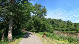
Just past GAP Mile 62, is arguably the highest point on this segment; you’ll definitely feel that way after climbing the hill, even though the hill itself isn’t difficult at all, or even long. But it does stop at a nice overlook with a couple of interpretive signs and a bench.

This overlook gives you a good view of the actual confluence (pun intended) of the Youghiogheny, Casselman, and Laurel Creek.


The interpretive signs here are placed both by the Great Allegheny Passage Conservancy and by the DCNR.
Speaking Of Interpretive Signs…!
If you’ve followed these posts and/or the accompanying YouTube videos, you already know how much I “love” interpretive signs.
OK, so I’m not “in love” with them… that’d just be weird. But I do like the fact that interpretive signage is placed at various points along a number of trails I’ve frequented. I think that these signs not only offer a break from what may otherwise be a mundane ride or hike, they provide the trail user with historical context and information of interest along the way.
Because most of this segment runs within the boundaries of Ohiopyle State Park, the area is managed by the Pennsylvania Department of Conservation & Natural Resources, the same state agency that oversees all of Pennsylvania’s state parks.


So, as you ride or hike along, you’ll see these interpretive signs that have been placed by the DCNR.
The Calm Before the Storm – or Rapids
The area of the Youghiogheny River from the outflow to about 3 miles from Ohiopyle are the calm before the rapids… literally.
This whole area is very heavily used by rafters, canoers, kayakers and other watersports enthusiasts who want a nice, relaxing float down the river and don’t want to (or can’t) brave the rapids further downstream.


As you ride this segment, peek through the trees – the closer you get to Ohiopyle, you’ll start to see a little stirring in the river. Remember I said that this river is shallow around here, so the small bits of rapids start to become more frequent, and the water seems to flow faster, the further downstream we get.
The “Dead Zone”

If there’s one thing you can rely on along the rural segments of the Great Allegheny Passage, it’s intermittently losing cellphone service. This segment is no different. From about mile 64 to about mile 69, most people lose signal completely.
While I’ve never done an exhaustive survey of everyone, I have heard that in this mid-trail “dead zone”, some people on certain carriers such as Verizon may have intermittent voice signal but will lose data access, while others such as on T-Mobile and AT&T will lose all service completely for a few miles.

So, the guidance remains the same – be careful, let people know where you are, and make sure you download your trail-app maps and your music (if you listen to music on your rides) before heading out.
Fortunately, most times of the trail season, this segment can be heavily used, so if you do get into trouble and find yourself without cell service, you’ll very likely – and very shortly – find someone able and willing to help out.
Trail Impression
This 10.6 mile segment of the Great Allegheny Passage from Confluence to Ohiopyle is a peaceful, frequently-shaded trail that’s very easy to ride and offers fantastic views of the river and other nature along the way.
While it can be busy at times, it never seems so crowded as to be annoying, and the trail users are often very friendly.
And let’s not forget that this segment is “bookended” by two of the most iconic trailhead towns on the Great Allegheny Passage – Confluence and Ohiopyle!