The Great Allegheny passage starts in Cumberland, Maryland and runs approximately 150 miles through fantastic scenic hills and valleys, to Pittsburgh, Pennsylvania.
In this post, we’re going to explore the trail segment from Cumberland to Frostburg, Maryland.
History of the Trail
For a more detailed history of the Great Allegheny Passage, please see our overview.
History Along The Way: Trailhead Town History
In this series of posts for the Great Allegheny Passage, I’ll touch on the history of the trailhead town associated with the start of each segment. In this way, I won’t be duplicating information about trailhead towns in multiple posts.
Cumberland

Cumberland is a city in western Maryland nestled along the historic Cumberland Narrows, a natural pass through the Appalachian Mountains, and bordering the Potomac River. It has a rich history deeply intertwined with the development of the United States itself, particularly during the westward expansion and industrialization eras.
The area, originally inhabited by Native American tribes including the Shawnee and the Lenape, saw European settlement in the mid-18th century, with the land eventually becoming part of the British colony of Maryland. In fact, Cumberland was named by English colonists after the son of King George II, Prince William, the Duke of Cumberland.
Cumberland also serves as the eastern terminus of the National Road, the first major improved highway in the United States. Authorized by Congress in 1806 and constructed between 1811 and 1837, the road connected Cumberland with the Ohio River and facilitated westward migration and trade.
During the 19th century, Cumberland experienced significant industrial growth, driven by its access to natural resources such as coal and iron ore, as well as its transportation infrastructure. The Baltimore and Ohio (B&O) Railroad, one of the nation’s first major railroads, reached Cumberland in 1842, further stimulating economic development in the region.
Cumberland was also the western terminus of the C&O Canal, that was constructed in the 19th century to facilitate transportation between the Chesapeake Bay and the Ohio River Valley.

Stretching 184.5 miles from Georgetown in Washington, D.C., to Cumberland, Maryland, the canal was designed to transport goods such as coal, lumber, and agricultural products from the western regions of Maryland, Pennsylvania, and West Virginia to markets in the East.
The completion of the C&O Canal in 1850 turned Cumberland into a bustling canal town, and increased the city’s importance as a hub for commerce and transportation.
The city also played a significant role in the American Civil War. Located in the border state of Maryland, Cumberland was strategically important for both Union and Confederate forces. The city was a key transportation hub for the Union army and served as a supply center and hospital base during the conflict.
In the late 19th and early 20th centuries, Cumberland continued to thrive as an industrial center, with industries such as glass manufacturing, textiles, and locomotive production contributing to its economy.

Cumberland encountered two major floods of the Potomac River. The flood of 1924 caused major damage to portions of the C&O Canal and was primarily responsible for its permanent closure west of the Georgetown (Washington D.C.) area.
The second flood in March 1936 caused even more damage to the abandoned canal, and saw the highest water mark the Potomac River had ever had to that time, destroying lockhouses, levels, and other structures.
In the 1950s, the US Army Corps of Engineers embarked on a major flood prevention project along Wills Creek, which can be seen along the first mile or so of the Great Allegheny Passage trail. It has successfully prevented any major flooding in Cumberland ever since.
However, like many industrial cities in the United States, Cumberland faced economic challenges in the latter half of the 20th century due to deindustrialization and changes in transportation infrastructure.
Despite these challenges, Cumberland has worked to preserve its rich history and heritage, with efforts to revitalize its downtown area and promote tourism based on its historical significance and natural beauty.

The Western Maryland Railroad acquired land at the end of the C&O Canal, near where the Wills Creek empties into the Potomac River (“the little basin”), and created a station at that spot. It remains there today and serves as the Cumberland Visitor Center and the station for the Western Maryland Scenic Railroad. It’s also the focal building at Canal Place, where a granite marker notes the end of the C&O Canal, and an in-ground plaque that marks the start of the Great Allegheny Passage.

Today, Cumberland remains an important regional center in Western Maryland, with a diverse economy and a strong sense of community pride in its storied past.
A vibrant brick pedestrian mall along Baltimore Street boasts restaurants, art galleries, and gardens. Several hotels and B&Bs provide accommodations, particularly for cyclists doing multi-day full tours from Washington D.C. to Pittsburgh.
Canal Place also has a cycle shop and outfitter, a salon, and open-air concert venue, new e-bike charging stations; also, restaurants of all types are either on-site or an easy walk – or ride – from Canal Place.


Trail Details
Trail Length
Starting at the inground marker at Canal Place, the Cumberland to Frostburg trail segment measures at 15.5 miles to the lower portion of the Frostburg Trailhead. This is the official mileage as per the Great Allegheny Passage Conservancy.
However, as with other trails that have large trailhead areas, there are some discrepancies in where this trail segment actually begins and ends.
Now, I love AllTrails.com – even more than TrailLink for one major reason: unlike with TrailLink (at least right now), you can live-track your activities and link them to their curated trail details with AllTrails.
However… when traversing the Great Allegheny Passage, AllTrails reverses many of the curations, starting from Pittsburgh and going to Cumberland, which is opposite to what many would think would be logical, in that to travel from mile zero, up to mile 150. So it is with this segment; AllTrails quotes the start at Frostburg and end at Cumberland (AllTrails maps note the start/end points of a trail with a green and black dot respectively).


With that said, AllTrails makes a huge error by placing the “end point” (their trail map counts Frostburg as the start and Cumberland as the end point) a good ½ mile beyond the “Mile Zero” marker at Canal Place, where it’s universally agreed that the Great Allegheny Passage actually starts.
To compound the confusion, AllTrails marks the “start point” of this segment at the Frostburg Depot for the Western Maryland Scenic Railroad, up the hill from the parking area for the trailhead using multiple switchbacks in the trail.
Though up at the depot, there are some nice scenes and seating areas and a food-truck type of eatery by the Trail Inn, this trek up the switchbacks adds ½ mile to the length, that the Great Allegheny Passage Conservancy doesn’t technically calculate.
Incidentally, TrailLink marks the trailheads at the appropriate spots.
So, I’ll go with the Great Allegheny Passage Conservancy’s start and end points, and its calculated mileage.
Trail Surface
Starting at Canal Place, you can either use the paved driveways along the parking spots, or use the brick walkway that connects the Great Allegheny Passage with the C&O Canal Path along the shops at Canal Place and a great view of the train station and visitor center.
Once off the bricked walkway, the trail follows the paved road/parking area up to Baltimore Street, where the trail crosses and traverses a sharp zig-zag bend along the railroad track bridge over Wills Creek. From there, it’s pure paved surface for about the first whole mile. At this point, the trail begins to diverge from Wills Creek, and starts up the 14+ mile hill to Frostburg. At this point, the treadway is crushed limestone, with paved sections crossing intersecting roads and the railroad tracks that the trail crosses several times.
The surface is bricked through Brush Tunnel, and the trail side of the tunnel is lighted. Note that this tunnel is shared between the railroad and the trail. There are signs warning you not to enter the tunnel when a train is approaching through the tunnel.
Trail Signage
The Great Allegheny Passage utilizes standardized signage, as I mentioned more specifically in my overview of the trail that you can find here.

Trail Views
The views are frankly, spectacular. Historical buildings await you in Cumberland itself. As you traverse up the trail towards Frostburg, the sweeping mountain vistas are almost always to your right, from the Cumberland Narrows itself to Helmstetter’s Curve to Savage Mountain, there’s definitely something all along this trail segment to make you repeatedly say, “wow, that’s so cool”.
Trailheads
Cumberland: Mile Zero

The start of the Great Allegheny Passage trail is at Canal Place in Cumberland. There are a good variety of parking spots, with ample parking for handicapped access, and electric vehicle charging stations adjacent to the trail.
The GAPTrail.org website notes that new e-bike charging stations have been installed at Canal Place (see above for a photo).
There are a number of shops at Canal Place, including a bike shop/trail outfitter. Also, if you use Cumberland as a “base” for an out-and-back, I’d recommend taking advantage of the restaurants including The Crabby Pig, and European Desserts & More. European Desserts & More doesn’t just have desserts – although their tiramisu is do die for – they also do hand-crafted coffees!
I’ve included a few photos of the Canal Place amenities above in the history of Cumberland section.
Cash Valley Road (LaVale, MD) (GAP Mile 5.2)
Just after the 5 mile mark, the Cash Valley Road trail access features about 8-10 parking spots in a single file. As the name implies, it’s accessible from Cash Valley Road, right after (or before if you’re coming in from the west) the trail and railroad crossing. The parking lot is not incredibly wide, and I’ve seen some longer vehicles with bike hitches have to make multiple-point turns to get in or out of the parking spots. While passing by this access, be careful of such vehicles, as sometimes they can “reach over” onto the trail while trying to exit.


This access is the closest parking access to Helmstetter’s Curve.
Woodcock Hollow (Savage Mountain, MD) (GAP Mile 9.6)
This is a very small parking area, with space for only about 3 vehicles. It sits about 9.5 miles from the start of the trail. It doesn’t have any specific signage. The parking spaces sit on a paved surface just north of the trail itself. There is a rest station just beyond this trail access point.


Frostburg (GAP Mile 15.5)
At 15.5 miles, the Frostburg trailhead technically sits right along the trailside. While the description of the parking area on the GAPtrail.org website claims that this parking area is a “small lot with room for fewer than 10 cars”, it is in fact, a large double-sided parking area able to accommodate about 22 vehicles in total. It’s accessible by turning onto Depot Terrace from National Pike (the main street through Frostburg), which winds down a hill to the Western Maryland Scenic Railroad terminal, where you’ll turn right down New Hope Rd NW to the trailhead parking lot. This lot is at the bottom of a switchback featuring bicycle-themed public art.


The actual “small lot” is at the top of the switchback adjacent to the Trail Inn. There is a larger lot adjacent to the Thrasher Carriage Museum which likely will allow trail users to park there, but given its location, the probable priority for parking would be for the museum and the train station.

Interestingly, you’d have to traverse the switchback – that contains A LOT (and that’s an understatement) of very loose fine gravel and six very tight turns – to access the Frostburg train station, the Trail Inn and food truck, the Thrasher Carriage Museum, as well as Tracks & Yaks which is on one end of the train station. They rent railcars that can be ridden from Frostburg down to Cumberland.
I’ve never done this myself, but I’ve seen some of the railcar riders flying down the tracks in the past and it looks pretty cool! Oh, and thanks to a nice young lady who I met during filming for this segment, I found out they also have a supply of bike tubes available!
Riding the Trail: Trail Tips
The First Mile is Urban
The first mile of the Great Allegheny Passage runs through Cumberland itself, first along Canal Street and the parking area for the Cumberland Visitor Center and Western Maryland Scenic Railroad station.
It then crosses Baltimore Street – which at the time of this writing, still had road construction in the area and in any case is a busy street as cars do not necessarily stop for cyclists and pedestrians, though I’d assume that they’re supposed to.

Immediately after crossing Baltimore Street, the trail crosses the active railroad tracks, then continues on paved surface, at some points paralleling active roads until it passes over the Western Maryland Railroad Bridge and near the Cumberland Narrows.

There are two trail options at the half-mile mark, where there is a parking area for the trail. One option has the trail run alongside the parking area and the IA Construction Company buildings, crossing the company and parking area access road, then under the Valley Street bridge. This option runs about 1/10 of a mile.

The other option here is to use the paved trail that makes a right-hand 180-degree turn alongside Lee Street, then crosses Valley Street at its intersection with Lee Street, connecting to the first option north of the Valley Street bridge. This option is slightly longer at 2/10 mile.
Lover’s Leap (mile 1.5 ish)
A little short of 2 miles on the trail, the view across Wills Creek is noted by an interpretive sign highlighting the legend of Lover’s Leap.

So goes the legend, a Native American Princess fell in love with a young English trapper named Jack. They wanted to marry, but her father, Chief Will, wouldn’t allow it.
After Jack found a map to a silver mine supposedly located in the Narrows, he offered it to Chief Will in return for the princess’ hand.
While the chief agreed, he reneged on his promise after he possessed the map. After a fight ensued during which Jack accidentally killed Chief Will, the princess resolved that while she could never marry the man who killed her father, neither could she live without the man she loved. So, arm in arm, they both walked up to the highest precipice in the Narrows and leaped to their death.
Supposedly, it’s just a legend.
Cumberland Narrows (Mile 2)
Let’s get one thing straight: the “Cumberland Narrows” is not the same as the “Cumberland Gap” as the Gap is hundreds of miles further south than Cumberland, Maryland. However, they are both natural breaks or “gaps” in the otherwise relatively continuous Appalachian Mountain range.

The Cumberland Narrows shows off a beautiful landscape of the south side of Wills Mountain. The natural water gap was formed over thousands of years of stream erosion of the sandstone surface, creating a 900-foot deep gorge and what’s now known as Wills Creek.
Due to its unique topography and natural passage through the Appalachian mountains, the route was part of a Native American footpath known as Nemacolin’s Trail. It was this passage and trail that later became instrumental for frontiersmen, as well as for movement of military troops, and eventually the development of stable transportation routes such as railways and the National Road.
The Great Allegheny Passage runs through the Narrows between mile 1.5 and 2.3.
From Pavement to Crushed Limestone
Just after passing the Mile 2 marker, you’ll encounter the Western Maryland Railroad Bridge, which carries both the Western Maryland Railroad and the Great American Passage across.

After crossing the bridge, the treadway turns to crushed limestone at this point, and (with short exceptions for road crossings) remains this type of surface up to Frostburg.
Cumberland Bone Cave (Mile 4)
Right at mile 4, just before the end of the near 180-degree sloping curve, you’ll reach the Cumberland Bone Cave on the left of the trail.
The story is that when the original rail line was constructed in 1912, a local naturalist discovered fossils among the rocks blasted from the site.


This prompted an official excavation of the site by paleontologists from the Smithsonian Institution that same year. They reportedly uncovered 41 genera of mammals, including a saber-toothed cat that is now on permanent exhibit in the Ice Age Mammal exhibit at the Smithsonian National Museum of Natural History in Washington, DC.
Though the story and the site is pretty fascinating, don’t expect to see too much – the public aren’t allowed to enter the cave, and to that end, a small fence blocks the entrance, giving just a view of the cave itself. But to go spelunking yourself, no joy.
Helmstetter’s Curve (Mile 5)
Among the most famous railroad landmarks east of the Mississippi River, Helmstetter’s Curve is a 180-degree horseshoe curve of the rail line now used by the Western Maryland Scenic Railroad. It’s situated just north of the Cash Valley trail access. It features a wide vista, and is a popular spot to stop and grab a photo or two.

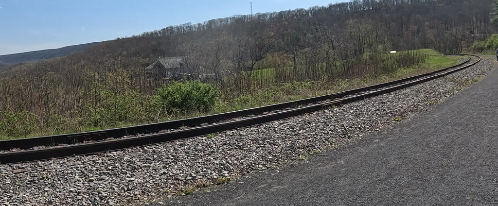
If you’re lucky enough, you may also encounter one of the Western Maryland Scenic Railroad trains passing by.
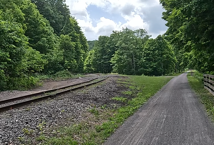
Brush Tunnel (Mile 6.5)
The 911-foot long Brush Tunnel was constructed in 1911 by the Western Maryland Railway as part of its expansion from Cumberland to Connellsville PA.
The tunnel carries both the Western Maryland Scenic Railroad tourist trains and the Great Allegheny Passage, with the trail and the tracks running parallel to each other.


So, if you see a train about to pass through, it’s best to wait for about 10 minutes after the train passes, because the train’s exhaust fumes can be suffocating!
The View of Mount Savage
At about 11.5 miles on the trail, you’ll find a sweeping vista of the town of Mount Savage on the right. Situated at the base of Big Savage Mountain, the town of Mount Savage wasn’t named after the mountain, but for Thomas Savage, a land surveyor who traveled through the area in 1736.

Multiple Railroad Crossings
The Great Allegheny Passage crosses the Western Maryland Scenic Railroad tracks five times on its way from Cumberland to Frostburg. The first two crossings are in the Narrows area, first crossing right (so that the tracks are on the left of the trail), then toward the end of the Narrows, crossing back over to the left (so that the tracks are again on the right of the trail). North of Helmstetter’s Curve, the trail crosses again. The last two crossings are to the left after the trail exits Brush Tunnel, and finally after the Woodcock Road intersection and trail access, the trail crosses to the right. This leaves the tracks on the left of the trail the rest of the way up to Frostburg.


Saying Goodbye to the Railroad (Sort of)
Just past 14 miles on the trail, the rail line starts to diverge away from the trail. It’s at this point where the track curves southwest from the trail.

The track then curves in an inverted S-shape, crossing above the trail twice until it finally continues southwest up to the Frostburg station.
The Two Faces of the Frostburg Trailhead
Ah, the Frostburg trailhead. As mentioned earlier, the trailhead appears to have two faces. The most obvious part of the trailhead is right next to the trail, replete with covered seating area, bicycle repair station, Porta-Potty, water fountain, the official Great Allegheny Passage signage, and the large, 22-space parking lot; these are all there by the trailside, along with a maintenance shed.

The other “trailhead” mentioned by some trail apps and map sites, is on the top of the half-mile switchback to the Western Maryland Scenic Railroad terminal. There is a bit of GAP signage up there, but nothing like as detailed at the signage at the trailside.
There are some interesting (and possibly necessary) features on the top of the switchback, however.
A relatively “new” feature at the top of the switchback is “Miner’s Park” a memorial walk with interpretive signs honoring the contributions – and hardships – of the region’s miners to American industry and our history.


Additionally, the switchback trail segment ends opposite the Trail Inn, featuring a “food truck” type eatery with ice cream and seating areas. Also nearby are the Thrasher Carriage Museum, and the Frostburg train station, with Tracks & Yaks filling the far side of the station.


All of this said, it is a bit of a fun haul up the switchback trail to the top, and even more fun coming down – with the caveat that you have to really slow down going around the very tight turns. But by all means, try it – it’s cool… just don’t ride it like a motocross track – be very careful and go very slowly.
Trail Impression
Overall, the Cumberland to Frostburg segment of the Great Allegheny Passage is a fantastic and relatively easy uphill ride offering a variety of views and features. The fact that it parallels an active railway, giving users (at least on weekends) the opportunity to encounter the passenger train on its way to or from Cumberland, or rail-car riders from Frostburg to Cumberland, is an added bonus.
While there are some portions of this segment that have a slightly steeper upslope than others, this segment – and the next segment of Frostburg to Deal, comprise the most uphill elevation change that you’ll encounter on the Great Allegheny Passage. Compared to the Maryland segment, traversing the more consistently flat or very slight graded surface of the Pennsylvania segments are much easier on the legs. Obviously, your personal physical condition should dictate how you approach this segment (as well as the Frostburg to Deal segment).
But if you pace yourself and listen to your body, don’t let the upslope stop you from experiencing the Great Allegheny Passage from where it all begins!


