The Coal and Coke Trail is a relatively short trail by cycling standards, but excellent for those who want a long walk. It abuts the Jacobs Creek Multi-Use Trail, making for a slightly longer trek for cyclists, if maybe a slight headache for hikers, since the current alignment of the trail takes users partially through the streets of Scottdale, which is certainly discouraged for walkers.
Because these two trails abut each other, I’m going to cover them together.
History of the Trail
The development of the Coal and Coke Trail traces back to the late 1990s when development work began along the old Pennsylvania Railroad corridor, now run by the Southwestern Pennsylvania Railroad and is an active line (more on them later).
The development work was led by local organizations, local and county governments, and was supported by the Regional Trail Corporation. The goal was to create an inter-borough recreational space for walking, running, cycling, and (reportedly) cross-country skiing, while highlighting the area’s industrial heritage.
According to TrailLink.com, it was opened in 2007. It’s currently maintained by volunteers of the Coal and Coke Trail Chapter of the Regional Trail Corporation.
The development of the Jacobs Creek Multi-Use Trail is a bit more of a mystery, because not much is publicly available about its development. However, it appears to have been developed around the same time as the Coal & Coke Trail, since the Jacobs Creek Watershed Association was formed in the 1990s.
One thing we do know: it was a cooperative partnership between the Borough of Scottdale, the PA Department of Conservation & Natural Resources (DCNR), and the Pennsylvania Department of Transportation, along with local groups like the Jacobs Creek Watershed Association.
History Along The Way
The two main trailheads are the towns of Mount Pleasant and Scottdale, both in Westmoreland county in the southwestern portion of Pennsylvania. The trail passes through localized neighborhoods including Bridgeport, Hammondville, and Iron Bridge.
Mount Pleasant
Mount Pleasant is one of the oldest towns in southwestern Pennsylvania, reportedly founded in 1797 by Samuel Rumbaugh, who laid out the original town plan. It grew at the crossroads of two Native American pathways, one of which was known as Glades Path from Bedford to Washington, which the current Pennsylvania Route 31 generally follows, known as “Main Street” in Mount Pleasant itself.

The “New Purchase” of 1768, a land treaty concluded between the British Crown and the Iroquois Confederacy “Six Nations” Native American tribes, further expanded William Penn’s original land grant from the Crown in 1681 (for whom “Pennsylvania” is named). This treaty and the land acquisition that it enabled effectively created southwestern Pennsylvania, and made it easier for the settlement of lands west of the Appalachian Mountain range.
Because of the town’s placement at this junction of Native American pathways, it’s known as the “town that grew at the crossroads“. This opportunity brought settlers – including Englishmen, Scots, Irishmen and Germans, many of whom were Revolutionary War veterans – to the town. They built taverns, inns, and blacksmith shops to accommodate travelers who passed through.
It’s also interesting to note a moniker given to Mount Pleasant: “Helltown”. The area farmers prospered, growing items used for the area, and also grain often used for making whiskey which was an easy cash commodity to transport back to eastern markets. But in 1794 during the Whiskey Rebellion, federal troops who were encamped in the town began arresting the local “Whiskey Boys” who protested the new whiskey tax, thus earning the name “Helltown”. Interestingly, someone must have hat-tipped to this historical moniker when they assigned Mount Pleasant the ZIP code: 15666!

A side note if you’re a “craft beer” fan: there’s a brewery called “Helltown Brewing” that keeps that spirit of the “Whiskey Boys” alive, and is definitely a must-check-out place when you visit the trail – just look at this map and see how close the Mount Pleasant taproom is to the trailhead!
Mount Pleasant is also notable as the birthplace of General George C. Marshall, who served as US Army Chief of Staff during World War II, and later as Secretary of State and Secretary of Defense, and was the chief architect of the “Marshall Plan” for European recovery after World War II.
Mount Pleasant is also known for many craft works. Henry Clay Frick, originally clerking at his uncle Overholt’s store on Main Street, eventually was able to consolidate the area’s coal and coke industry and became a millionaire by age 30.
Another well-known craft of the area was its glass factories. Bryce Brothers, founded in 1850 in Birmingham in nearby Allegheny County, later moved to Mount Pleasant and and was well-known for its hand-blown crystal. It continued operations until the mid-1960s when it was acquired by Lenox Crystal, a company which continues to this day, although no longer in Mount Pleasant. Lexox Crystal’s Mount Pleasant plant was closed in the early 2000s, and its outlet store at the site of the former plant, was closed in 2020.
Also prominent was LE Smith Glass, founded in 1907 by Lewis E. Smith. Although closed due to bankruptcy in 2004, LE Smith Glass pieces remain in high demand among collectors and were promoted among a number of high-profile individuals and companies including Martha Stewart, Neiman-Marcus, Williams Sonoma, Spiegel and Bloomingdale’s.
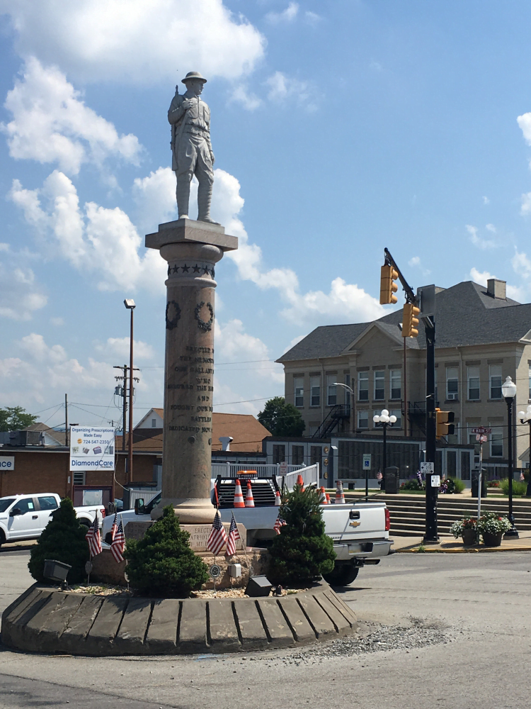
One of the iconic features of modern Mount Pleasant is the “Doughboy”, a statue of a World War I US Army soldier, or “doughboy”. It’s placed in the middle of the intersection of Main & Diamond Streets, an area known as “the diamond.”
The history and spirit of Mount Pleasant is embodied in the annual “Mount Pleasant Glass & Ethnic Festival” which is held on the last full weekend in September each year. If you haven’t been yet, it’s definitely worth combining a trail ride with a visit to the the Glass Festival!
Scottdale
Scottdale was officially founded in 1874 by prominent railroad entrepreneur Thomas A. Scott, who extended rail lines through the area after seeing the importance of the region and the nearby Jacobs Creek to the coal, coke, and grain industries that were growing at the time.

Because of the importance of Jacobs Creek, many settlers were drawn to the area. By the early 1800s, the village of West Overton had grown up around a rye distillery which was owned by the Overholt family; while closer to where the modern-day Scottdale is, numerous mills utilized the flowing water of Jacobs Creek to grind flour, creating the town of “Fountain Mills”, which was later renamed “Scottdale” in Thomas Scott’s honor.
Mennonites flourished in this area as well, as some of the early settlers of the region. Scottdale was also the home of the Mennonite Publishing House which continued operations until 2002. The Scottdale Mennonite Church remains a vibrant member of the variety of churches in Scottdale.
Scottdale became a hub for the coal and coke industry, due to its location pretty much in the midst of hundreds of mining companies in the late 1800s and early 1900s. It’s said that some 30,000 coke ovens were located in the Scottdale area. The railroads that ran through Scottdale were used to ship the coal and coke products across the country.
Jacobs Creek, which is pretty wide for a “creek” in my opinion (oh, and there’s no clear consensus on who “Jacob” was), runs by one side of Scottdale, as well as the Coal and Coke Trail in various points. At certain points, it marks the border in this area between the counties of Westmoreland and Fayette.

This waterway was used extensively in the industrial boom of the 1800’s and early 1900’s thanks to Henry Clay Frick (remember him?).
Frick was born in 1849 in West Overton, a settlement just east of Scottdale proper (a suburb?). As part of his work in expanding the coal and coke industry in the region, he headquartered his “H. C. Frick Company” in Scottdale, and proceeded to pepper the entire Jacobs Creek watershed – which runs a little over 30 miles from Acme to the Youghiogheny River – with coal mines and coke ovens to fuel the growing western Pennsylvania steel industry.
You can see the remnants of this industry when you take a peek at the creek and its watershed, which the Coal and Coke Trail borders at certain points. There are some places where either the water or the shoreline appear milky-blue to light bluish-green, indicating the presence of aluminum, while some spots sport a rusty-orange color indicating the presence of iron precipitates.
Over the years, the coal and coke industry had declined and Scottdale has had to continually adapt. The railroad is still used, though. The Southwestern Pennsylvania Railroad maintains a railyard in Scottdale and is an active “shortline” railroad, hauling for various industries in the area, including manufacturing and fracking operations, linking these business operations to larger interchanges with the likes of Norfolk Southern and CSX.
The Scottdale Historical Society works to preserve the history and heritage of the town, and it seems as if the town isn’t dying off any time soon.

In fact, Scottdale is turning 150 years old this year (2024), and their annual Scottdale Fall Festival (held annually on the third weekend in September) promises to capitalize on this milestone! Just one tip: don’t try riding through town during the Festival weekend – it’s impossible, because the town part of the trail (see below) runs right through the park where the festival is held.
Trail Details
So with that history lesson out of the way, let’s look at the practical aspects of the Coal and Coke Trail and the Jacobs Creek Multi-Use Trail.
Trail Length
This is a bit of an unintentional controversy, which is rather unusual for the rail-trails I’ve encountered.
The Coal and Coke Trail Chapter itself quotes the trail length as 5 miles, on a brochure they published in 2014 that can be found on the trail page on the Westmoreland County website (it doesn’t look like the Chapter has its own website, but they do maintain a Facebook page). Interestingly, the brochure which detailed the endpoint at Kendi Park, noted that the Chapter has “future plans to also provide a link to the West Overton Museum and downtown Scottdale.” Certainly since 2014, the “downtown Scottdale” section was laid out, as you’ll see below.
The trail’s webpage on Pennsylvania’s Department of Conservation and National Resources, claims the length is 4.76 miles.
AllTrails.com claims the trail length is 3.8 miles (7.6 mile out-and-back) with the start and end point for their out-and-back trail length calculation being the Mildred Street trailhead. AllTrails has a separate entry for the Jacobs Creek Multi-Use Trail, citing it as being 0.6 miles (1.2 mile out-and-back).
But a closer look reveals that AllTrails has a bit of a problem here, because not only do they shorten the Coal and Coke Trail length and tracking by a good 1.2 miles based on the Chapter’s own map, they also reverse the start point of the trail.
In addition to this glaring error, AllTrails misses a good 0.6 miles between the Mildred Street trailhead and where they put the turnaround point for the Jacobs Creek Multi-Use Trail.
The national Rails To Trails Conservancy and its mobile app TrailLink, is technically the most accurate with trail length and tracking. Their map shows the trail as a total of 6.1 miles point-to-point from Willow Park in Mount Pleasant to Garfield Park in Scottdale.
TrailLink combines both the Coal and Coke Trail and Jacobs Creek Multi-Use Trail in their tracking, which I personally think is the best way to do this, even if the Coal and Coke Trail Chapter may tend to disagree.
TrailLink also notes that the remaining slightly over 1 mile of the Jacobs Creek Multi-Use Trail that I’m noting here, was “completed in 2019, leads to the center of town and terminates at Garfield Park on Church Street.”
Clearly, the various interested parties need to get their story straight regarding proper mileage and tracking of these two trails.
Trail Surface
The Coal and Coke Trail is primarily crushed limestone. The trailheads and inter-trail access points are paved and have the typical barriers at these points to prevent larger motorized vehicles from accessing the trail while allowing easy access for both non-motorized and motorized bicycles (e-bikes).
From the Mildred Street trailhead to Overholt Drive, the Coal and Coke Trail follows residential streets: Mildred Street which turns into Bessemer Street, then turns left on Overholt Drive, where the crushed limestone returns for about 1/10 of a mile until the trail veers to the right and up a slight slope, where a paved surface returns for the duration of its length to the Scottdale trailhead.
This paved portion is technically the start of the Jacobs Creek Multi-Use Trail, and has a spur trail that leads to Kendi Park proper with its playground and soccer fields.
From the Scottdale trailhead, following the Jacobs Creek Multi-Use Trail is pure road surface. More on that in a bit.
Views & Signage

The Coal and Coke Trail is fairly well marked with clear signs pointing the way at junction points. Up to the Mildred Street trailhead, there are mile markers along the edge of the treadway, along with a interpretive marker at the Bridgeport junction (the 1.5 mile mark) which I’ve inserted below.
Along the Coal and Coke Trail itself, before it reaches Kendi Park, you can expect to pass through some diverse natural habitats. Though it’s said that there are remnants of old coke ovens along the trail, I personally haven’t seen any (please leave a comment below if you know where these may be).

There is a slag heap beside the trail just after the Bridgeport junction. Apparently a portion of this slag slid onto the trail a couple of years ago, and caused that portion of the trail to be closed for months while the trail was cleared.
The Trailheads
There are two main trailheads for the Coal and Coke Trail, and several trailheads/access points along the trail.
Mount Pleasant – Route 31
The presumed start of the Coal and Coke Trail is at the Mount Pleasant trailhead close to Willow Park (which Google Maps claims is its own trailhead). I say “presumed”, because as you travel this trail starting at Mount Pleasant, the mile markers along the trail start with “mile zero” at this point.
The trailhead is easily accessible from Main Street (PA Route 31) literally at the bottom of the hill whether you’re coming from east or west through town. You’ll turn right (or left if you’re coming from the east) onto Cook’s Way. It’s named this because Cook’s Build-It Hardware used to be opposite the parking area. You can still see the building, (now housing American Architectural Salvage), which you’ll ride past at the start of the trail. The map below shows that there are about 10 parking spots along trailhead. Be careful, though, because locals use Cook’s Way and its connecting Standpipe Alley (which Google Maps has misspelled as “Sawdpipe”) as a thoroughfare to avoid the traffic light at Main Street and Center Avenue.

Speaking of the abandoned Cook’s Hardware building, there’s a mural painted on the side of the building at the trailhead… it’s pretty cool.

Willow Park Trailhead
Accessible from Center Avenue, the Willow Park trailhead has a decent amount of parking available. Willow Park also features a couple of small baseball fields and a pavilion. There is a small spur trail from the parking area that connects to the main trail.

Allegheny Power Trailhead
This trailhead is approximately 2.5 miles from the start of the trail. It’s on Sewage Plant Lane accessible from Mount Pleasant Road, and sports several open parking spaces. I bet you can guess why it’s called “Sewage Plant Lane”… the East Huntingdon Township sewage plant is at the end of this road.

Note that if you continue southwest on the trail towards Scottdale, the trail actually uses Sewage Plant Lane which is a residential street. It then has to cross Mount Pleasant Road – so please look both ways and be careful. More on that later
Mildred Street Trailhead
This is a small trailhead on Mildred Street in Scottdale, which is actually an off-shoot street from Bessemer Street, which itself is accessible from Overholt Drive. It has a small parking lot which I’d guess would hold about 8-10 vehicles. It’s about 4 miles in from the trail start. This trailhead is technically the closest to the West Overton Village attractions which are available in-season, by taking Overholt Drive north to Porter Avenue (PA Route 819) and crossing it to the shops.

You’ll use Mildred Street to reach the trail just to the south if you want to go toward Mount Pleasant. If starting here and traveling toward Scottdale, you will be using the Mildred Street – which turns into Bessemer Street, to its intersection with Overholt Drive. Again, these are residential streets, so please be careful and make sure motorists know you’re there.
Kendi Park Trailhead
Just short of 4.5 miles from the trail start, there’s a spur trail to the right that takes the trail user up to Kendi Park. It’s a large park that’s also the home of the of the Scottdale Soccer Club, a youth soccer organization. The trail spur stops at Mt. Pleasant Road, so to access the parking area for this trail access, you’ll have to take Mt. Pleasant Road for about a 1/10 of a mile.
The Kendi Park trail access parking is on grass with gravel accessway surrounding the grass parking spaces. However, given that there’s a lot of grass area, it’s possible to fit over 30 vehicles here.
The trail access also has a Porta-Potty and full restrooms at the Soccer Club’s pavilion, soccer fields (of course), a ball field, basketball hoop, and a small playground.
Scottdale Trailhead
About 5 miles from the trail start, you’ll find the Scottdale trailhead. It is accessible from Mt Pleasant Road, which itself is accessible from either Overholt Drive or North Broadway Street, the part of PA Route 819 which is one of the major thoroughfares in Scottdale.
For some reason, however, Google Maps labels this as “Coal and Coke – Kendi Park Trailhead” even though it’s not technically attached to Kendi Park itself. This trailhead’s sign says “Jacobs Creek Multi-Use Trail” and makes no mention of the Coal & Coke Trail

This trailhead is also used for the Scottdale Canoe Access Ramp for Jacobs Creek. It sports a 18 paved and lined parking spaces with two of them for handicapped access. It also has a pavilion, a covered seating area, and some benches – but no other amenities.
While entering or leaving this trailhead, beware the big bump – I’ve pointed to it on the map above – it’s a rather high speed bump!
This trailhead is actually at mile 5 and the end of the Coal & Coke Trail.
It’s also for safety considerations, the end of the walking part of the Jacobs Creek Multi-Use Trail for now, because the remainder of the trail follows the road surfaces in Scottdale.
Garfield Park Trailhead
The trail technically ends at Garfield Park in Scottdale. This park and trailhead is at the end of Church Street, accessible from South Broadway Street (Broadway Street splits north/south at Pittsburgh Street effectively in the center of town).

There’s no lack of parking space here, but as of my last visit, there aren’t any specifically marked out as handicapped access. There’s also a little league baseball field at Garfield Park, so I’d guess that parking may be at a premium during game days.
Riding the Trail: Trail Tips
As you plan your outing on the Coal and Coke Trail and Jacobs Creek Multi-Use Trail, here are a few tips to keep in mind.
It Parallels an Active Railroad
The trail from Mount Pleasant to the Allegheny Power trailhead follows closely along the Southwestern Pennsylvania Railroad, which – unlike some rail-trails – is an active railroad (but fortunately for trail users, it’s not very busy). So obviously, some caution is advised if you do happen to see a train passing your way.

Along the Slag Heap
The trail junction at Bridgeport has an information sign, seen below. Pretty interesting reading. Unfortunately there’s no “you are here” marking on the sign, but “you are” just to the right of Buckeye Road along the green line marking the trail.

Once crossing over Buckeye Road, you’ll see the SWPRR tracks on the left, and a large slag heap on the right:

Crossing Mt Pleasant Road and Under US 119
As I’ve mentioned previously, upon exiting the Allegheny Power trailhead, the trail uses Sewage Plant Lane until it intersects with Mt Pleasant Road. The trail crosses Mt Pleasant Road and proceeds toward an underpass of US 119.


Up the Hill to Mildred Street
There’s a small upslope as the trail reaches the Mildred Street trailhead. Once past the barriers, the trail follows Mildred Street and Bessemer Street, to an intersection with Overholt Drive.

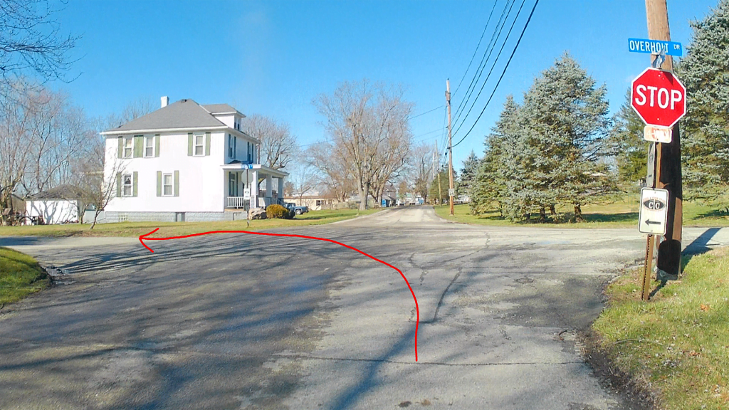
Drain Culverts on the Treadway
After turning left from Bessemer Street to Overholt Drive, there is a crushed limestone treadway along the roadside for about 2/10ths of a mile until the trail veers right away from the road surface. However, thanks who whoever was responsible for construction of this portion, several rectangular drain culverts were built – right on the treadway! I know, pretty weird.


The worst of them are pictured above. Be really careful, because it’s probably not too hard to hit this thing and ruin a wheel.
Danger, High Voltage!

After leaving Overholt Drive, the trail follows a slight upslope and is partially paved, but returns briefly to crushed limestone as the trail runs adjacent to a fenced-off property that appears to be part of the “Bin There Dump That” company fronted on Mt Pleasant Road. There are multiple signs on the fencing that claim that the area is “alarmed” and that the “electric fence” carries “7,000 volts”. Personally, I’m not willing to test out the veracity of those signs, but just be careful, as the edge of the treadway comes pretty close to the fencing, and on the portion closest to Overholt Drive, there isn’t a lot of berm between the edge of the treadway and the fence. I guess “don’t touch the fence” is good advice.
Jacobs Creek Multi-Use Trail Playground and Canoe Access
After passing the fenceline, the trail returns to a paved surface. The paved circle (on the right side of the picture below) is the actual start of the Jacobs Creek Multi-Use Trail itself.

A bit further down the trail, you’ll encounter a spur trail to the right that provides access to the playground and rest areas of Kendi Park. If you’re riding with children, it’s a great spot to take a break for a bit.

Kendi Park Trailhead – The Big Speedbump
Kendi Park Trailhead is, by some accounts, the western terminus of the Coal and Coke Trail. This trailhead is also used by canoers (is that a word?) who park there to access the canoe ramp at this trailhead.
As mentioned earlier in the description of the trailhead itself, the accessway from Mt Pleasant Road has a large speedbump along it, so when you’re exiting the trailhead to continue on the Jacobs Creek Multi-Use Trail segment of the Coal and Coke Trail (at least as defined by TrailLink), roll over this bump s-l-o-w-l-y.
Scottdale Road Access
From the Kendi Park trailhead, you’re turning left onto Mt Pleasant Road to reach North Broadway Street, then a quick left onto Edwin Avenue, and up to Spring Street.
Fortunately for cyclists, the borough did a fantastic job of clearly marking the trail pathway by means of painted arrows on the road surface.
Also note that Broadway Street is pretty much the major thoroughfare in Scottdale and can be very busy at times. But it’s not impossible to navigate this – just make sure you’re seen and use hand signals. I’m pretty sure that the locals don’t expect a massive amount of cyclists on the roads. Fortunately, the rest of the trail path covers less-busy town roads.

Spring Street To and Through Gazebo Park
Once you reach Spring Street, you’ll continue along it for several blocks and through several intersections (stop, look and listen!). Two blocks of Spring Street still use the old-style paving stones – pretty cool!
Once you reach the Scottdale Public Library, the trail path turns left into Gazebo Park and along the sidewalks, again using the clearly marked pavement arrows. Apparently, this accessway marked for bicycle use used to be known as “Stoner Street” – at least according to Google Maps. I think someone also needs to tell Google Maps curators how to spell “GAZEBO”. I’d like to check with the Scottdale Historical Society to see what the actual history of Stoner Street was, presuming it was there before the park was built and it just got relegated from road to sidewalk.
As noted on the map below, the trail exits Gazebo Park by crossing Pittsburgh Street and follows Stoner Street, which at this point is actually a paved road.

Side note: On Pittsburgh Street, there are a variety of shops and a couple of banks.

If you’re into coffeehouses, may I suggest Bad Rabbit Cafe & Roastery – the food, coffee, and atmosphere are excellent! Just one word of caution, there are no easy bike lock-points along Pittsburgh Street, except perhaps for the parking meters. These apparently aren’t used during the weekends, but are certainly useful to lock your bike against – just use a tight wrap if you use a chain. There is also no outdoor seating for any shop or restaurant on Pittsburgh Street, but there’s plenty of nice seating at Gazebo Park across the street.
Back Alleys to Church Street
From Stoner Street, the trail markings direct you along O’Neill Alley for a couple of blocks, then right onto an unnamed alley for 7 blocks. There are intersections all the way, so again be careful, and you’ll finally reach Church Street, where you’ll turn left. At the intersection of Church & South Broadway, you’ll continue on Church Street through this busy intersection, to Garfield Park at the end of Church Street.


Garfield Park
At Garfield Park, the trail ends (see map photo in the Trailheads section). Interestingly, opposite the parking area, there’s a gate that appears to be for a trail extension – and the road arrow points right, clearly indicating that the trail was supposed to continue in that direction.


Since the Coal and Coke Trail Chapter indicated in their brochure and on their Facebook page that a long-term goal was to connect these trails further down Jacobs Creek to the Great Allegheny Passage, this may be the junction point of the intended trail extension. But for now, there’s no clear right-of-way, so it’s blocked from access.
Trail Impression
Overall, the Coal and Coke Trail and its abutting Jacobs Creek Multi-Use Trail is an excellent and very well-maintained sub-10-mile trail for various outdoor activities. It has multiple mid-trail access points to be able to enjoy even small sections of the trail. It combines scenic wooded areas with quaint town vignettes, and has multiple options for stopping to rest, play, or eat and drink.
No matter how long you want to claim this trail is, it’s an easy ride overall, and can be used pretty much throughout the year (weather permitting).
I’m hoping that long-term plan for connecting this trail to the Great Allegheny Passage comes to fruition, because I’ll definitely be riding that portion as well!


Pingback: Trail Highlight: An Update on the Coal & Coke Trail
Pingback: The Great Allegheny Passage: Connellsville to Whitsett