The Allegheny River Valley Trail is both a loop trail and a connecting point-to-point trail situated in a picturesque area of western New York state.
It should not be confused with the “Allegheny River Trail” that runs along the eastern bank of the Allegheny River in Pennsylvania between Emlenton and Franklin.
History of the Trail
The original 5.5 mile loop trail that encircles Saint Bonaventure University and passes through portions of the town of Allegany and the city of Olean, was the brainchild of local businessman Joe Higgins, who lobbied extensively for a multi-purpose recreational trail in the area.

His efforts included garnering the support of the Cattaraugus Region Community Foundation, local politicians, and other stakeholders including executives at Saint Bonaventure University.
After extensive efforts that included obtaining grant money and the final permission of Saint Bonaventure University — on whose land some of the trail sits — the Allegheny River Valley Trail became a reality in 1998.

The 2.1+ mile connector trail through Olean, long envisioned, was made a reality several years later after additional grants were secured to build the portions of the connector trail that didn’t already use existing roads or walkways.
I’ve heard from a representative at the Cattaraugus Region Community Foundation that one of the foundation’s long-range plans include creating an riverside connector trail from the Allegheny River Valley Trail to the Allegany State Park that’s about 11 miles west of Saint Bonaventure University.
History Along The Way
Allegany
The town of Allegany is located just west of Olean in Cattaraugus County. Its history is tied to the development of the “Southern Tier” of New York and the growth of Saint Bonaventure University.

The Seneca Nation of Native Americans, part of the Iroquois Confederacy, originally inhabited this entire area, using the Allegheny River as a vital transportation and trade route. It’s good to note that the entire western New York region has a variety of Native American inhabitants and influence to this day. In fact, the Seneca Nation has an active community not too far from the town of Allegany.
European settlers first arrived in the early 1800’s and the town of Allegany was officially formed in 1831 from the town of Great Valley.

Allegany developed as an agricultural and lumber-producing community. Logging was especially important in the 19th century, with sawmills operating along the Allegheny River.


The Allegheny River and later the arrival of railroads helped fuel trade and connect Allegany to regional markets in northwestern Pennsylvania and the lower upstate of New York, sometimes referred to as the “Southern Tier.”
The Roman Catholic Franciscan order founded Saint Bonaventure University in 1858, just outside of the village, and it ultimately grew into a major regional university and spiritual center for the Roman Catholic Church.


The Village of Allegany was incorporated in 1906, developing its own identity apart from the surrounding rural town. It became a small but vibrant community with shops, churches, schools, and social life centered around both the village and the university.


Today, Allegany is largely a residential community, known for its proximity to outdoor recreation and its close ties to the university. The village and town support a mix of students, faculty, and long-term residents.
The Western New York and Pennsylvania Railroad, a short-line railway that serves as a connector to nearby industries and larger railroads, maintains an active rail yard and maintenance facility in Allegany.
Olean
The city of Olean, New York also has a rich and varied history shaped by industry, transportation, and natural resources.
First settled by non-Native Americans around 1804, the area was originally called “Hamilton.” It was renamed “Olean” in 1808, derived from the Latin word oleum (meaning oil), reflecting early interest in petroleum seeps in the area.


It’s said that the first oil discovered in North America was about 12 miles north of the current city area. This was the northern extent of what geologists call the Bradford Oil Field, that ran from Cattaraugus County into northwestern Pennsylvania.
In the mid 1800’s, oil wells and production facilities sprouted in the Olean area, and the area also played a crucial role as a transportation hub during the Pennsylvania oil rush in the late 1800s. It was a refining and shipping point for crude oil coming from nearby fields.
Olean became an important railroad junction, with lines like the Erie Railroad and the Pennsylvania Railroad passing through. This made it a key link for goods, including the nearby logging and lumber industries, some around nearby Allegany, as well as for travelers.


Olean was incorporated as a city in 1893 and saw growth in its downtown area, with commercial buildings, schools, and institutions like nearby Saint Bonaventure University.
By the early 1900s, Olean had developed into a significant industrial center in the region. It was home to companies like Clark Brothers Company (later Dresser-Rand), which made oil and gas equipment, among many other industries.


After the manufacturing downturn in America, Olean has worked to revitalize its economy with a focus on healthcare, education, and service industries.
Historic buildings have been preserved, and efforts to enhance the quality of life—such as parks and cultural activities—continue to shape the city’s identity.

Sometimes nicknamed the “Enterprising City” as a nod to its entrepreneurial roots and its ongoing efforts to reinvent itself through the years, Olean continues to live up to its promise as the city “Where Small Town Charm and Big City Industry Meet.”
Trail Details
Trail Length
An absolute figure may be technically disputed primarily because of how long one wants to claim that the “Olean Connector” trail (as I’ve consistently called it) actually is.
Main Loop
The easy part of the length calculation is the loop trail that starts and ends at the western student lot of Saint Bonaventure University. From the start post, around the trail and back to the start post, the full loop is 5.5 miles.


Actually, the Cattaraugus Region Community Foundation (who manages the trail) is very specific in the trail’s brochure, as it clocks the full loop mileage as “5.548 miles.” You can obtain the trail map brochure either online, at the trailhead, or at Higgins Park (see below).
Bona Loop
The Foundation marks out a separate “Bona Loop” trail that makes a shorter loop just around the university, that they measure at 2.58 miles. This loop diverges from the Main Loop trail around its 1.25 mile mark, traverses along the eastern side of the university property, and joins the Main Loop at the university’s main entrance.
Olean Connector
Again, this is my term for the subsequently-built trail segment that connects to the Main Loop around mile 3.75, and runs through the city of Olean.
The Cattaraugus Region Community Foundation marks out this connecting point-to-point trail, but they don’t actually measure it on their map.
According to Google Maps, the Olean Connector is 2.1 miles one-way from the loop junction to its terminus at War Veterans Park.


There is a separate section of the Olean Connector trail that juts south for about ½ a mile north of East State Street, and terminates at Four Mile Brewing on East Green Street.
Thus, the Olean Connector can be said to be either 2.1 or 2.5 miles point to point, depending on which eastern terminus you want to use.
Dueling Trail Maps
TrailLink.com lists the Allegheny River Valley Trail as an 8.1-mile trail, but looking at their description and their trail map, it appears that they’re arriving at this figure because they’re adding the ½ mile southerly portion that terminates at Four Mile Brewing to their overall calculation – which theoretically would make sense.

AllTrails ignores the Olean Connector and the Bona Loop completely on their map, and marks the trail loop measurement at 5.6 miles (very close to the actual).


But a small point of ire from me that has nothing to do with trail length: AllTrails named their curation “Allegany River Valley Trail”, using the spelling of the town’s name, not the river’s.
(Did I ever say how annoyed I get with spelling errors? Ask the nurses in my practice – I get on them all the time for that!)
So Just How Long Is This Thing?
So, doing the math, and assuming an Olean Connector terminus at War Veterans Park and completely ignoring the Four MIle Brewing terminus, the numbers look like this:
5.548 (Main Loop) + 2.1 miles (Olean Connector one way) = 7.648 miles.
TrailLink is closest with its 8.1 mile claim, if riding or walking both eastern portions of the Olean Connector – but only one way.
But if you start at the loop, do the connector like I did on the video for this trail, who’s going to actually finish at either Olean Connector terminus and just stop counting?
In that case, when we assume that you start at the Main Loop, take the Olean Connector junction, ride or walk to both eastern termini and back to the loop and finish it, the numbers then look like this:
5.548 (Main Loop) + 5.2 miles (Olean Connector out-and-back going to both termini & back) = 10.748 miles.
So What?
But who’s counting? This is such a fun and easy trail to ride, I doubt that many of us would really care that it’s claimed to be less than 10 miles from start to finish on many trail maps, when it’s actually just over 10.
Trail Surface
The entirety of the Allegheny River Valley Trail is paved, with an average 8-foot wide treadway width. There are several bridges that cross over streams, and have a wood-plank decking. There are also a fair number of road and driveway crossings that you can see if you watch the accompanying video, but none of them are extremely difficult – I’d say the busiest crossings are the two “Main Loop” crossings of West State Street.
Some portions of the pavement are bumpy, particularly along the river and the first half mile of the Olean Connector.
Portions of the Olean Connector use road surfaces, including the Wayne Street bike lane, and other portions use sidewalks by the Olean School District sports complex and through the Jamestown Community College’s Olean campus.
Trail Signage
Though the Allegheny River Valley Trail has official trail signage, you won’t see a lot of it along the trail because the paved trail is rather obvious to follow.
Trail Views
The Allegheny River Valley Trail has a fantastic mix of shade trees, excellent views of the Allegheny River, college grounds, and quaint town scenery. As a loop trail, it’s very easy to do multiple times in succession if you’re looking to pump up your miles.
Trailheads
Saint Bonaventure/Allegany (Loop Trail Start)
The primary trailhead for the loop trails – both the Main Loop and the “Bona Loop” – is at one of the primary student parking lots for Saint Bonaventure University. It’s accessible from Bonaventure Road.
The primary parking for this trailhead is along the trailside itself, with 15 spaces available including three handicapped accessible spaces.


On weekends and in between semesters, it appears that it’s also possible for trail users to use the student parking area, although parking away from the trailside should be appropriate and respectful of the students while classes are in session.
The trailhead features a bike rack and a picnic table as well as a map kiosk with a holder for the trail brochures. There are no other amenities at this trailhead, however there is a public restroom available on the opposite side of the campus on Clare Road.
Gargoyle Park
Sitting on the edge of the border between Allegany and Olean, and at about the 2.5 mile mark on the loop, Gargoyle Park is frequented by the locals during the summer months for a variety of public events.
Since it’s an actual park, it’s not surprising that it has a large, enclosed pavilion, a playground area, multiple seating areas, and what looks like bike racks around the park. Gargoyle Park also has an 18-hole Disc Golf course, reportedly the first in Cattaraugus County.
The parking area is at the end of Gargoyle Road. It’s a decently-sized unlined gravel lot that I’d estimate can hold about 20 vehicles. There aren’t any dedicated handicapped spaces.

There are technically two trail spurs that will reach the trail from the parking area, but I wouldn’t recommend using the gravel one (seen on the right side of the picture below) – it connects with a gravel service driveway and is barred by a locked metal gate. The other spur leading to the trail (seen on the left side of the picture below) is paved – but to get to that spur from the parking area, you have to cross a patch of grass.

In other words, while this is a good option for parking, those who maintain the park haven’t exactly catered to cyclists by creating an easily-accessible and fully-paved trail spur… at least as of the time I filmed the trail in early 2025. Hopefully that will change.
Olean (War Veterans Park)
War Veterans Park is large park in the city of Olean, and marks the easternmost terminus of the Olean Connector. it’s accessible from Front Street.
Since it’s a public park, It has a very large paved parking area for over 140 vehicles with at least two dedicated handicap spaces.


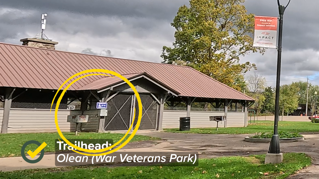
Within the park, there are a number of benches, a covered event building, a playground, water facilities, bike racks, and the Olean Recreational Center that’s behind the event building that has restroom facilities available. There’s even something I’ve never seen before – on the front of the covered pavilion, is a “wheelchair charging station”!
East Green Street/Four Mile Brewing
Four Mile Brewing is along East Green Street, and next to it is a building that has a sign on it marked as “OIean Lumber Co.” This building appears to me (at least) to no longer be in active use.
There is building-side parking here for about eight vehicles, as well as additional streetside parking on East Green Street and at 4 Mile Brewing itself, that has its own parking lot.


However, it does not appear to me to be specifically reserved parking for the trail. In fact, there aren’t any amenities at this trail access point. I’d guess that Four Mile Brewing would allow you to park in their area, if you’re planning on riding or walking the trail, and coming back to enjoy a brew!
Riding The Trail (Trail Tips)
It All Starts Here (or at least it probably should)
The loop trail technically starts at the mile marker that’s just beyond the Saint Bonaventure trailhead.
At this point, you can technically go either west toward the river, or east along the front of the university. However, the mile markers clock from the westward-starting direction.


But, given the fact that there are other areas to park and stage along the loop trail and at the ends of the Olean Connector, you don’t technically have to stage here. But you probably should.
Remnants of the Railroad Era
OK, let’s get one thing straight. The Western Pennsylvania & New York Railroad’s terminal in Allegany (though it’s listed as “Olean Terminal”) isn’t a remnant. It’s an active rail yard for the WPNY.
No, what I’m talking about are remnants of railroad bridges across the Allegheny River and Olean Creek.
Just prior to reaching the quarter-mile mark on the loop, the trail curves to the left to parallel the river. At this curve, look out over the river. You’ll see the remains of a bridge pylon. According to Dennis Frank with the Saint Bonaventure University Archives, this is what’s left of an bridge used by the old Pennsylvania Railroad that once crossed the Allegheny River at this point.


The other pilings that Dennis identified are close to the mouth of Olean Creek, that can be seen from the bridge over the creek along East State Street, which forms part of the Olean Connector trail segment to War Veterans Park. Apparently these are the remains of an old railroad grade for the Pittsburgh, Shawmut and Northern Railroad.
It’s Not A Football Field

At about the half-mile mark on the loop, you can see the back of Saint Bonaventure University, specifically, an athletic field for the university.
You would be forgiven for thinking (as I did and mentioned as much on the video) that it’s a football field.
However, Dennis Frank, the Saint Bonaventure University archivist, corrected me on this. The university doesn’t have a football program. This is actually a rugby field. Nonetheless, it looks really cool from the trail.
Tracking The (Quarter) Miles
There are a number of trails that utilize a quarter-mile marking system. Many of these are loop trails, but some are point-to point, and nearly all of them are intended for mixed use; i.e., meant for walkers and joggers but also welcome cyclists.

The Allegheny River Valley Trail is no exception here. You’ll see the quarter-mile markings all along the loop. While most of the markers are low to the ground (usually about a foot or so high) and on the right side of the trail, some are on the left.
The Olean Connector has some mile markers, but it’s not consistent since a good portion of the connector relies on roads and public walkways, such as through the community college.
River Watching
The trail parallels the Allegheny River for about two and a half miles, meaning that you get some really nice views of the river. The trail design actually took this into consideration by installing a number of benches along this portion – many of them that face toward the river.


From what I’ve been told, this is a “four-season” trail, so you can enjoy the lower portion of the trail and the river views all year round.
The Bona Loop
Close to the 1.25 mile mark on the Main Loop (the 1.25 mile mark would be just beyond the first bridge), you’ll see the junction with the “Bona Loop.”

Taking this junction, you’ll follow the trail along the eastern side of the university property and back to its main entrance road where it connects back up with the Main Loop.


This creates a shorter loop around Saint Bonaventure University (hence the name “Bona Loop”). The Foundation lists the shorter “Bona Loop” as being a total of 2.58 miles
The Many Two Mile Crossings
The Allegheny River Valley Trail crosses over Two Mile Creek three times – twice around the Main Loop, and once for the Olean Connector… or “four” times if you do the connector as an out-and-back to the junction with the Main Loop… but I digress.


All of the bridges are wood-plank decking. It’s probably safe to say that Two Mile Creek can range from a trickle to a decent flow of water – and decent views – depending on the time of year.
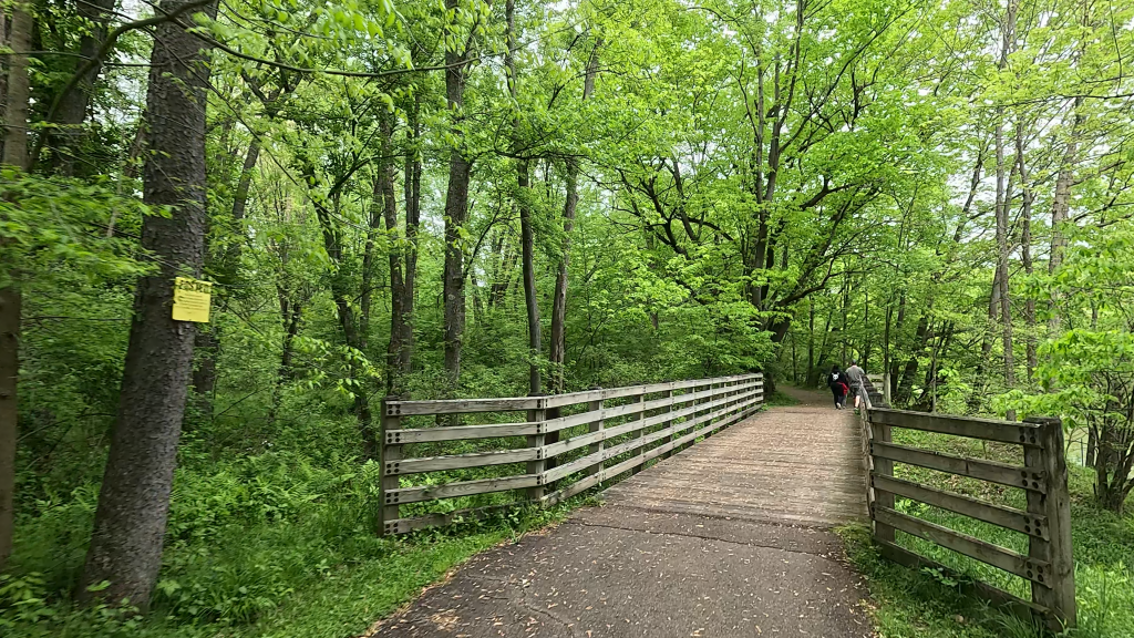
There’s a third wood-plank bridge along the Main Loop that you’ll encounter shortly after leaving the Gargoyle Park area, but I’m not sure of the name of the creek over which that bridge crosses, because it doesn’t appear to be named on any maps that I’ve found.
Crossing The Street(s)
The Main Loop crosses over West State Street twice. If you’re riding or walking the trail in the direction of the mile markers (that is to say, from 0 to 5.5), the first crossover will be shortly past the 3 1/4 mile mark in Olean, and the second crossover is at the 5 mile mark in Allegany by the main entrance to Saint Bonaventure University.


Close to both crossovers, you can find a bicycle repair station and a water fountain. While the water fountain at the Allegany crossover works, the one in Olean doesn’t – at least as of this writing.


Since these are both very busy intersections with traffic lights, I don’t recommend trying to ride across them. It would be better to use the pedestrian signal that’s available, wait for the light, and walk across.

You’ll encounter another busy road crossing shortly after passing the Olean Connector junction while on the Main Loop. This crosses Constitution Avenue. While there is a pedestrian crossing signal here, there’s no traffic light – so don’t expect people to stop for the pedestrian signal, even though they should.
From the Constitution Avenue crossover until you reach the Allegany crossover for West State Street, the trail runs over driveways for a number of businesses. Some of them have stop signs for the trail, and some don’t, so use good judgment.
The Olean Connector has its own road crossovers that we’ll discuss below.
The Vin Fiz

On the right side of the trail after the West State Street crossover in Olean, there’s an interpretive sign.
This marker commemorates the first American transcontinental flight made by Calbraith Rodgers. He landed in Olean on September 24, 1911, on his way from Sheepshead Bay, NY (in Brooklyn), to Long Beach, CA. His flight took a total of 91 days, starting off on September 11 in Brooklyn, and landing in Long Beach on December 10.
The Fork In The Road

OK, so maybe there isn’t exactly a literal “fork” in the road. But very close to the 3 3/4 mile mark on the Main Loop, and after the second crossing over Two Mile Creek, you’ll find the junction with what I’ve been calling the Olean Connector.
As I touched on earlier, a representative at the Cattaraugus Region Community Foundation informed me that this connector trail into Olean wasn’t in the original grant budget for the loop trail. The foundation was finally able to secure funds, and this connector was added a few years later.
Mind The (Lack of) Gap
While the Olean Connector starts out at the junction with its own paved trail, once you reach the half-mile point on the connector, this is about to change.
At this point, the trail makes two 90-degree bends through three sets of rather tightly-placed trail barriers, continuing on another small patch of paved trail until the trail pavement ends at the sidewalk of North 12th Street.

These three trail barrier sets are so placed that I wouldn’t expect most cyclists to try going through them at speed. I know I didn’t!
Share The Road… and the Sidewalk… and the College Walkway…
At the end of the first paved portion of the Olean Connector, the trail crosses under a nice decorative arch next to the sidewalk of North 12th Street.

This is the point where the trail needs to follow the road. There’s no easy way to get from the edge of the paved trail to North 12th Street other than either popping off the curb, or riding the sidewalk up to the entrance of the Country Fair convenience store that’s at the corner of North 12th Street and Wayne Avenue.

The trail turns right at his intersection, and follows Wayne Avenue for a bit. But Wayne Avenue only has one painted bike lane, and it’s along its southern lane (that is, into the Olean central business district). So, if you’re going to ride the Connector to one of the termini and head back to the loop, you’ll either have to dodge traffic on the outbound lane without a dedicated bike lane, or use the sidewalk on the southern side of Wayne Avenue.
While using the sidewalk isn’t necessarily ideal, it actually becomes necessary once you reach the Olean School District’s athletic complex, because the bike lane goes away and the official map marks the trail as being between the complex and the railroad tracks just beyond the complex.


The trail returns to using road surfaces for a bit, using North First Street, turning left onto Whitney Avenue, and crossing over North Union Street and onto the walkways for Jamestown Community College.


Fortunately, the paved trail portion returns at the other end of the campus, and is present all of the way down to Chamberlain Park, a little parklet near East Green Street.
If you’re confused by all of the surface changes, watch the companion video for this trail – it should make a lot more sense. Also, ride this trail once, and you’ll see that it’s not really that difficult.
It’s Still An Active Railroad
Yes, by all accounts, the Western New York and Pennsylvania Railroad is still very much an active short-haul rail line serving the general area.
At around the 4.5 mile mark on the Main Loop, you can see the “Olean Terminal”, which is their local maintenance depot railyard.

Depending on the day of the week, you may be able to see some engines being worked on and trains rolling into or out of the depot.
A Tribute to Joe
Along the northern side of the West State Street trail crossover in Allegany, there’s a small parklet named “Higgins Trail Park”. It was built in honor of Joe Higgins (who is still very much alive as of this writing, by the way) for his vision and dedication that helped make the trail a reality.


The parklet contains some benches, greenery, and a LOT of engraved stones honoring all of the people and organizations who have contributed to the Foundation’s work of maintaining the trail.
Personally, I think it’s a nice tribute!
Trail Impression
The Allegheny River Valley Trail is a very nice and well-maintained loop trail that affords not only quaint college-town views and amenities, but also wonderful views of the historic Allegheny River and lush forested areas around Saint Bonaventure University that they’re very proud of as a member of “Tree Campus USA”.
And no matter how long that you want to claim the Olean connector trail portion is, it’s an easy ride, though a bit busier with its combination of on-road and multiple road-crossing portions. It’s a nice out-and-back addition to the loop trail!


