The Presque Isle State Park Multi-Purpose Trail, also known as the Karl Boyes Multi-Purpose National Recreation Trail, is a 13.4-mile loop trail that circles around the picturesque Presque Isle State Park.
Presque Isle State Park is the largest state park in Erie County, Pennsylvania, and sits on a 3,200-acre peninsula that juts out into Lake Erie, creating a very unique environment that combines beaches, wetlands, and diverse wildlife.
Especially notable for nature-lovers, the peninsula (and the park of course) is a critical stopover site along the “Atlantic Flyway“, a major north-south bird migration route. In fact, during migratory times of the year, visiting the park will yield you a wealth of bird-watching!
With its multiple northwest-facing sandy beaches, it’s considered Pennsylvania’s only seashore. The park itself is open year-round, sunrise–sunset, and offers a wide variety of recreational opportunities beyond biking and walking. The park is known for other year-round activities including fishing, boating, swimming, as well as cross-country skiing, snowshoeing, and ice fishing in the winter.
History of the Trail
While Presque Isle State Park has existed for many years, access to the park’s scenic areas was limited to a few road and informal paths. This made it difficult for park users to safely walk, bike, or engage in other activities.
Early Ideas
While it appears that ideas for a comprehensive path or trail around the park started to emerge as early as the 1960’s it wasn’t until the 1980’s when local advocacy for safe, accessible recreation spaces became a major public interest. Obviously, part of this interest would have been for increasing tourism to the area; but since Erie sits along a wealth of natural beauty, this was a logical draw.
While the call for some type of safe, accessible trail was growing louder, environmentalists raised concerns about the impact that a widely-used public trail would have on the park’s ecosystems, particularly on its wetlands, dunes, and wildlife habitats. This led to early planning efforts focusing on minimizing environmental impact while promoting responsible recreation.
Making the Moves
Enter Karl Boyes.

In the early 1990s, Pennsylvania State Representative Karl Boyes, a Republican who served Erie’s district, became a major proponent of the concept of a recreational trail around Presque Isle. Already known for his commitment to improving public recreational spaces, Boyes saw the trail as a key project that could benefit the community by encouraging tourism, fitness, and environmental appreciation.
Boyes worked closely with state and federal agencies to secure the necessary funding for the project. He advocated in Harrisburg, the state’s capital, for state funding and leveraged federal resources, recognizing the trail’s potential as a local economic booster and its importance for tourism.
Starting in 1994, with funding secured and environmental concerns addressed, construction began, carefully integrating the trail into the park’s existing landscape and ensuring that it didn’t disrupt environmentally-sensitive areas.
The trail was opened in stages as each was completed, eventually completing the 13.5 mile loop around the peninsula, taking trail users along the shoreline, through wooded areas, and past wetlands. The path was designed to be wide and paved to accommodate different types of users safely. Benches, signage, and bike racks were also installed along the route.
Honoring the Legacy
After his passing in 2003, the completed trail was renamed as the “Karl Boyes Multi-Purpose National Recreation Trail” in honor his tireless advocacy and dedication to making the trail a reality.
The trail is regularly maintained by the Pennsylvania Department of Conservation and Natural Resources (DCNR), the state agency that has direct jurisdiction over all of Pennsylvania’s state parks.
The Other Pieces of Presque Isle History
While Admiral Perry may have been the inspiration for the Perry Monument, there a a number of others who’ve made their mark on Presque Isle history.
GoErie.com has a great article featuring 15 important people who have shaped the past, present, and future of the peninsula in various ways.
Besides Karl Boyes whom we’ve already mentioned, these notables include:
- J.C. “Doc” Ainsworth, who created the lifeguard program for Presque Isle beaches (Ainsworth Beach is named for him);
- Frank Pettinato, who spent over 50 years as a Presque Isle State Park lifeguard, and was a major advocate for beach safety (Pettinato Beach is named in his honor);
- James Stull and Jean Stull CUnningham, who dedicated their time to the bird life and nature preservation on the peninsula (the Stull Interpretive Center is named after them);
- James Thompson, a state Park and Harbor Commission member who, along with Governor John Fisher, were responsible for planning and creating the initial roadways on the peninsula for the public to enjoy (Thompson Drive, Thompson Circle, and Thompson Bay are named after him).
History Along The Way
Presque Isle
Presque Isle is a naturally formed sandspit that extends into Lake Erie. Its name, French for “almost an island,” reflects its unique geography as a peninsula nearly surrounded by water.

The area was historically inhabited by Native American tribes, including the Erie and Iroquois, who used it for fishing, hunting, and as a portage route.

During the War of 1812, Presque Isle Bay served as the base for Commodore Oliver Hazard Perry’s fleet during the Battle of Lake Erie in 1813. The victory secured U.S. control over Lake Erie during the war.
In 1921, Presque Isle was designated as a state park to preserve its natural beauty and provide public recreation opportunities. Its dynamic environment, continually reshaped by wind, waves, and sediment deposition, features diverse habitats, including sandy beaches, marshes, forests, and lagoons.
Presque Isle State Park remains one of Pennsylvania’s most visited parks, attracting millions annually for its natural beauty, historical significance, and recreational activities.
Erie
Erie, Pennsylvania, is a city rich in history, rooted in its strategic location on the southern shore of Lake Erie.
The area was originally inhabited by the Erie people, a Native American tribe known for their agricultural and hunting skills. They were part of the Iroquoian language group but were displaced by the Iroquois Confederacy in the mid-1600s during a period of territorial expansion and conflict.

French explorers came to the area in the late 1600s. In 1753, they built Fort Presque Isle, near what is now downtown Erie, as a part of a strategic network of forts to protect their interests in the Ohio Valley.

During the French and Indian War in the mid-18th century, the region was a battleground as the French and British vied for control of North America. The British took over Fort Presque Isle after the French defeat in 1759 but later abandoned it after Native American uprisings, including Pontiac’s Rebellion in 1763.
The land now known as Erie became part of Pennsylvania in 1792 through the Erie Triangle purchase. This controversial deal involved settling land claims between Pennsylvania, New York, and Native tribes, giving Pennsylvania access to the Great Lakes.

During the War of 1812, Commodore Oliver Hazard Perry constructed a fleet at Misery Bay located along Presque Isle Bay. Perry’s fleet secured a significant victory over the British in the Battle of Lake Erie in 1813, ensuring U.S. dominance in the region. Erie’s identity as a maritime city was thus established.
With its prime location on Lake Erie, the city thrived as an industrial center in the 19th century. It became a critical hub for shipping, iron production, and fishing.
Erie’s importance grew with the expansion of railroads, but it faced challenges. In the 1850s, Erie became infamous for the Erie Gauge War, a dispute over rail width standards that disrupted rail connections and commerce. Sidenote: I had no idea that this was an issue until I was doing the research for this article. It’s an interesting glimpse into the history of Erie and its surrounding environs!
Through the 19th and early 20th centuries, Erie attracted waves of immigrants, particularly from Germany, Ireland, and Eastern Europe, who worked in its factories and built thriving communities. Throughout the early 20th century, Erie’s manufacturing sector boomed, producing everything from paper and locomotives, to rubber goods. General Electric, Hammermill Paper, and other major companies made the city an industrial powerhouse.


During World War II, Erie contributed to the war effort by producing military equipment, further solidifying its industrial significance.
However, like many Rust Belt cities, Erie faced economic decline in the latter half of the century due to de-industrialization. Factories closed, and jobs moved elsewhere, prompting population decline.
Today, Erie’s economy has shifted towards tourism and service industries. Presque Isle State Park, with its beaches and trails, draws millions of visitors annually.
The city has also been revitalizing its downtown and cultural offerings, with museums like the Erie Maritime Museum, which highlights the city’s nautical history, and the preservation of the U.S. Brig Niagara, Perry’s flagship from the Battle of Lake Erie.


Erie is also well-known for its educational and healthcare offerings. Institutions like Gannon University, the Lake Erie College of Medicine, Penn State-Behrend Campus, and Pennwest-Edinboro University (formerly known as Edinboro University of Pennsylvania) a mere 15 miles from Erie, as well as major healthcare players such as Allegheny Health Network’s St Vincent Hospital and UPMC-Hamot Hospital have become key drivers of Erie’s modern economy.
While Erie faces challenges such as population decline and economic restructuring, it continues to embrace its history, natural beauty, and position on Lake Erie. The city’s past as a maritime and industrial powerhouse remains central to its identity, making it a vibrant, historically rich community.
Trail Details
The Karl Boyes Multi-Purpose National Recreation Trail, loops around the outer edges of the entire peninsula, offering a variety of picturesque views of the bay, is a loop trail that circles around the picturesque Presque Isle State Park.

The treadway of the Karl Boyes Multi-Purpose National Recreation Trail is an average of 10 feet wide, and has recently been freshly paved (more on that below).
The eastern side of the trail follows its own course along the eastern shoreline, sometimes coming VERY close to the water’s edge. Other portions of the eastern side further north up the peninsula run parallel to the roadway, but have a grassy or sandy verge dividing the trail and the road. The trail goes over a small bridge carrying Fisher Drive not too far from East Pier, and another carrying Thompson Drive, just outside of the Perry Monument parking area.
Trail Length
There is a very slight difference of opinion regarding the actual trail length, though all sources agree that it’s 13 miles.
According to the DCNR who manages Presque Isle State Park, the length is 13.57 miles.
In slight contrast, TrailLink claims the length is 13.4 miles, while AllTrails claims the length is 13.3 miles.
Most likely, the 1/10 almost 3/10 mile differences can be attributed to exactly where each entity is specifically claiming the start/end point to be.
But realistically, unless you’re going to totally ignore all of the little side-trips and the mid-peninsula spur trail through the forest that can get you quickly from one side of the peninsula to the other, you’re very likely going to be clocking a bit closer to 14 miles in one loop.
This ADA accessible trail is popular with bicyclists, in-line skaters and joggers. The paved Multipurpose Trail, designated as a National Recreation Trail, begins at the park entrance, follows Presque Isle Bay shoreline, passes Perry Monument and continues around the eastern end of the park, back along the Lake Erie side of the park and ties back into the trail again near Duck Pond area. During the winter, the trail is plowed from the entrance to the park office for hikers. For cross-country skiers, the trail is left snow covered from the park office to Perry Monument.
Trail Signage
Since this is a loop trail, the DCNR doesn’t currently have any specific signage such as you’d see on other major trail systems like the Great Allegheny Passage, the C&O Canal, or the Erie Canalway Trail.
But that doesn’t mean that the trail isn’t well-marked.
On the eastern side of the peninsula, the trail is easy to follow because it’s separated from the roadway. Tighter turns, stop areas, and trail direction signs are laid out on the paved surface and/or on signs next to the treadway.
On the western side, it’s a bit trickier since part of the trail parallels the active roadway, and parts diverge from walkways or parking areas. These are all clearly marked however, by painted lines and arrows on the paved treadway surface.
Trail Views
Trailheads
Since this is a loop trail completely inside of a state park, the term “trailhead” is a bit of a misnomer here. Let’s instead call them trail access areas… and there are a LOT of them.
Starting at the park entrance, there are at least 35 (you read that right: THIRTY-FIVE) separate designated parking areas around the peninsula. Some of these parking areas are separate paved lots, while others are sand lots next to the beaches, and still others are small roadside or beachside parking areas that many users take advantage of during the season.
That said, while none of them are specifically marked as “trailheads”, all of them are available for public use of the trail itself. Later on in this post, I have an Google Earth image where I’ve marked most of those 35 spots.
I’ve ridden this trail a number of times over the years, and my favorite access is by the Perry Monument. But you can literally park anywhere, and loop back to your vehicle. As far as this park is concerned, I tend to use the terms “trailhead” or “trail access” for the big lots.
Riding the Trail: Trail Tips
It’s PAVED!
To anyone who’s never experienced this trail before, you may be thinking, “so, it’s paved, big deal!”
The point is, it IS a big deal.
After the last major overhaul of the trail many years ago, the treadway surface was extremely bumpy on the eastern side, causing more than one rider to fall (to my knowledge, and no, I never fell here). The portions of the western side of the trail that didn’t use part of the roadway surface weren’t much better.
But all that changed in 2024, when the state granted funds to the DCNR for a major repaving of the entire trail.

Now, the treadway surface is much smoother, and very easy to ride. So, on behalf of all of the more regular users of the trail (read: the locals of which I’m not), I’d like to say to those responsible for this repaving – from those who secured the funding, to the DCNR, and to the actual workers who did the paving work – THANK YOU!
Before Getting There – Or Huffing It Uphill to Get There
The entrance to Presque Isle State Park itself sits at the bottom of a small hill. Before you get there, you’ll pass Waldemeer Park & Water World on your left, and the Tom Ridge Environmental Center on your right.

The Environmental Center named in honor of former Governor and Erie native Tom Ridge, and offers educational exhibits about the history, ecology, and conservation efforts in the region.
I’ve known people to stop there for a visit before heading downhill to the park itself, and others who have huffed it uphill on their bikes to visit the Center, then heading back downhill to finish their day at the park.
If you’re interested in the environment, particularly the local environment and Presque Isle’s designation as an “Important Bird Area” due to the number of species that stop here on their migratory routes, it’s definitely worth visiting.
It’s BUSY!
Presque Isle is well-known and very heavily used for its beautiful sandy beaches. There are eleven numbered beaches, and several others named but not numbered, all along the western side of the peninsula where people swim, sunbathe, or just enjoy the scenic views of Lake Erie – including the incredible sunsets they get up here.
The eastern side – along Presque Isle Bay – is just as heavily used during the spring and summer for a variety of watersports, including boating, jet-skiing, kayaking, canoeing, and paddle-boarding. You can also see a lot of fishing going on along the eastern side of the peninsula.

As this is a major multi-modal state park, it can – and does – get VERY busy particularly during the summer. Also, while it’s technically open year-round, there are times when part of the roadway can be closed due to winter conditions. Interestingly, the DCNR keeps some of the “upper” or more northerly portions of the trail snow-covered during the winter for cross-country skiers to enjoy.
Remember, we’re talking about Erie here, well known for lake-effect snow, not just its great amenities and its colleges.
But don’t let the potential busyness of the park deter you from enjoying this fantastic trail. I know people who will make a whole day of their excursion to Presque Isle State Park. You can take in a round or two of the trail on your bike in the morning, then park it and enjoy any of the beaches in the afternoon!
The Yellow Bike – You Don’t “Have” To Bring Your Own Bike
With that last thought in mind of spending a whole day in the park – which is very possible to do – you don’t really need to bring your bike if you don’t want to. And for those who want to ride but don’t have a bike of your own, you’re in luck, too.

Just north of the Park Office, is the Yellow Bike Rental Company. They rent bikes, tandems, surreys, and child-carriers at very reasonable rates. They are open most days during the spring and summer season, but it’s still a good idea to check out their website before you head out. Just a note, they do close at the end of the biking season.
Start Anywhere, Stop Everywhere
There’s no trailhead/staging access precisely at the park entrance. So you can’t technically start or end your ride at the park entrance itself. The closest parking areas to the park entrance are along Old Lake Road on the western side, and about a quarter-mile up the trail on the eastern side of the peninsula.
But therein lies the beauty of Presque Isle State Park and this multi-purpose trail. Since it’s a loop trail in a very large, multi-modal state park, I mentioned earlier that there are a great number of parking areas throughout the park where you can stage for your ride or hike.

Take a look at this map where I marked all of the parking/staging areas around the peninsula. There are just too many of them to list here. But all that means is that you can literally start at any parking area, and loop back to it.
Not only can you pick wherever you want to stage, you can also pick how much of the trail that you want to do. There are several connecting roads between the eastern and western side of the peninsula, so even if you’re not up to a whole 13.5 mile loop, you can always start at a parking area close to the park entrance, and loop back at the Park Office, for example.
Personally, I’ve staged at various parking areas on the peninsula in past visits, but for some reason, the Perry Monument “trailhead” or parking area is my favorite – and it’s where I’ll be starting on the upcoming accompanying video on this trail.
Crossing The Street
Along the loop trail, there are a couple of road crossings to be aware of. In addition, there are a number of points where the trail crosses over parking access spaces, that I’ll list briefly below. I’m not including pictures of these crossovers, because if I did, you’d be scrolling for a long time!
Starting from the park entrance along the eastern side first and looping around:
- Park Entrance (Peninsula Drive): The first, and the busiest, is at the park entrance itself, where the you’ll cross Peninsula Drive. This is the “main drag” and the only road entrance into the park, so it’s a two-way, four-lane road that can get very busy during the weekends in the spring and summer. Be cautious here, because not everyone is going to see you standing on the side of the road with your bike and stop to let you cross. Dare I say that while the Erie natives are known to be quite friendly, this park gets tons of traffic from out-of-towners who may not be as generous.
- Niagara Boat Launch parking area: About a quarter mile past the Ranger Station/Park Office, the trail crosses the double driveways at the Niagara Boat Launch parking area.
- Presque Isle Public Docks: This one needs a bit of an explanation that I’ll delve into a bit more below, but at the public docks about 2/10 of a mile past the Niagara Boat Launch parking area, the main trail continues northeastward, while a connector trail bears left and crosses Peninsula Drive which at that point is still a two-way, four-lane road. This connector road is the same that is used to access the Yellow Bike Rental Company.
- West Fisher Drive: About 3/10 of a mile beyond the public dock, the trail crosses over West Fisher Drive. While the trail and West Fisher Drive traffic have a stop, Peninsula Drive traffic doesn’t. Going right on West Fisher Drive at this crossing will take you to the Presque Isle Marina and the West Pier.
- Fisher Drive: This crossing is about 8/10 of a mile on the trail past the West Fisher Drive crossing. Less than 1/10 of a mile before this trail/road crossing, Peninsula Drive loops back around to the west and south, and the two-way, two-lane road that continues northeast at this point is named Fisher Drive. This is a little less busy, but be aware that the road curves bit before this crossing. Fortunately, the speed limit through the park is 25 MPH, so drivers should be able to see you easily. At the other end of this crossing is a spur trail that we’ll talk about in a bit.
- East Pier: Almost 3/4 mile past the last road crossing, the East Pier parking area is on the right across Fisher Drive. While the main trail doesn’t actually cross the road at this point, you can cross the street at this point to check out East Pier.
- Fisher Drive: The next trail crossing over Fisher Drive is a little less than a half-mile past East Pier. After crossing, you’ll be right next to Presque Isle Bay all of the way up to the Perry Monument, where you can continue the spur to the monument itself, or continue on the main trail… speaking of which,
- Perry Monument parking area: there are actually two crossings here since the Perry Monument “trailhead” parking area is split into two portions. It’s at this point that the treadway is aligned with the road surface itself, separated only by a solid white line. The road changes names again at this point, and is called Thompson Drive.
- Coast Guard Road: After hugging Misery Bay for a little over a mile, the trail crosses Coast Guard Road twice. Coast Guard Road is technically a loop road that goes to the Coast Guard station (obviously) and loops around the Beach 11 (“Kohler Beach”) parking area and back onto the main road, which gets renamed again as Peninsula Drive.
- Budny Beach parking area: About another half-mile brings you to the northernmost beach on the peninsula, beach 10 (“Budny Beach”) where you’ll encounter a several parking area crossovers.
- Pine Tree Beach: A mile further on, the trail turns away from paralleling the road for a bit to bear right toward beach 9 (“Pine Tree”), crossing over a restroom access road. The Presque Isle Lighthouse isn’t too far away from beach 9.
- Pettinato Beach: Around beach 8 (Pettinato Beach), the trail turns right, crossing to one side of this very large parking area, and along the main walkway.
- Beach 6 parking area: Shortly after the trail reconnects to the one-way drive for the Rotary Pavilion, and the trail turns right into the trees, there are a couple of parking area accessway crossings by beach 6 (Lyons).
A Nature-Lover’s Paradise
As a very ecologically-diverse area, Presque Isle has several locations where a variety of wildlife can be observed. Presque Isle has a number of footpaths across the peninsula, that are only for hiking and cross-country skiing; wheeled vehicles are not permitted. These include Duck Pond Trail, Sidewalk Trail, Long Pond Trail, Ridge Trail, Marsh Trail, Dead Pond Trail, Pine Tree Trail, Graveyard Pond Trail, Old Gas Well Trail, Canoe Portage Trail, and North Pier Trail.
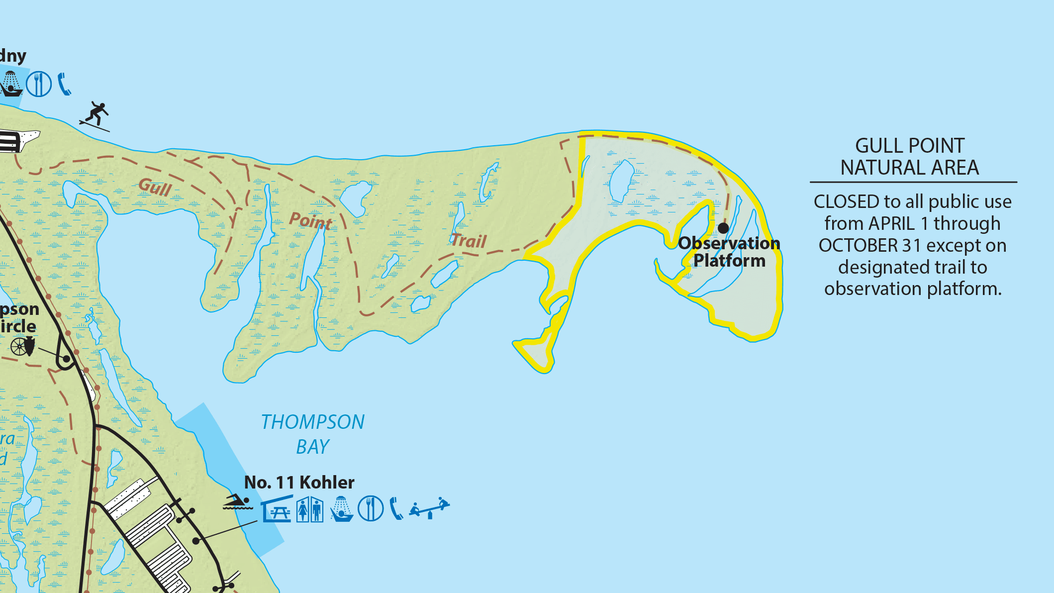
Also notable among the hiking trails is Gull Point Trail, accessible from the Budny Beach parking area. This trail connects to the Gull Point Natural Area, the easternmost portion of the peninsula, which is a protected wildlife area. It’s actually closed to public use from April through October except for its Observation Platform at the terminus of the trail.

But there’s another observation platform that’s right next to the multi-use trail, where you can park your bike and check out the habitat. The Feather observation platform is an elevated wood-plank walkway that overlooks a small lagoon at Leo’s Landing. The area was originally known as the West Boat Livery and was operated by Leo Hess (hence “Leo’s Landing”) from 1938 through the 1960s. There’s a sand walking path leading to the edge of the landing. This area is classified as an “Environmentally Sensitive Area” and keen observers can see migrating birds during their migration seasons.
Connections
While the entire loop trail from start to finish is over 13 miles, you really don’t have to do the whole loop if you don’t want to. Or, you can do the whole loop and then make smaller loops by using any of several roads and trail surfaces that connect the eastern side of the trail with the western.
Starting at the park entrance up to the Ranger Station/Park Office, these connectors are short and are alongside the connecting “turnaround” roads between the northbound and southbound lanes of Peninsula Drive. North of the Ranger Station, you’ll encounter a few more turnarounds, as well as the Waterworks connector trail, where the Yellow Bike Rental Company is located.
Even further northeast, is the Fox Trail, a multi-use paved connector trail that winds through the woodlands between Fisher Drive and Peninsula Drive. This connector trail is open for hiking and biking, though “surreys” (the 4-wheeled pedal bikes that Yellow Bike Rental Company rents) are not permitted on this connector.
Admiral Perry
The story of Admiral Perry and his contribution to the dominance of Lake Erie during the War of 1812 is legendary, and references to this person and this time in American history are dotted all around Erie.

The Admiral Perry monument sits at the mouth of Misery Bay, where he had built many of the ships used in the battle. I did mention briefly about Admiral Perry and the pivotal Battle of Lake Erie above (the link goes to the National Park Service’s page on the battle), and there are numerous sites that tell the whole story; so I won’t go into detail here.
The Admiral Perry Monument sits at the northeastern end of Presque Isle, at the mouth of Misery Bay. It’s a very busy trail access point during the season, and it has a spur off of the main trail that you can walk or ride up to the monument. There are also various interpretive signs around the circular plaza where the monument sits, though on occasion the DCNR may take one or two down for refurbishment.
On The Beach
All along the western side of the peninsula are multiple beaches – 11 numbered beaches along with others not numbered, according to the DCNR. While many of them are open for swimmers and sunbathers, some of them serve specific purposes.
Starting at the park entrance, the beaches start at beach 1, which isn’t named. Beach 3, or “Barracks Beach” is roughly parallel to the Vista #3 parking lot.
If you check out the DCNR’s official park map (available on PDF by clicking here), you’ll notice that there’s no beach 2, 4, or 5 for some reason, even though there appears to be a sand walking path all along the shoreline from beach 1 and passing the areas where numbered beach 2, 4, or 5 would logically sit, so it’s safe to assume that the shoreline is accessible if not recommended for swimming. It’s also possible that these unnumbered locations are not declared because of some environmental preservation reasons.

Alongside the parking area of beach 6, are a group of sand volleyball courts that encounter frequent use during the season – the trail runs right past these courts, and at various times, you’ll be likely to encounter a game or two, or even a tournament, going on.

Next up is beach 7, or “Waterworks Beach”, which is parallel to the western terminus of West Fisher Drive and the Rotary Pavilion. This point is also close to where the previously-mentioned connector trail passing the Yellow Bike Rental Company terminates on the western side of the peninsula. The trail runs directly along the landward side of this beach, and is a fantastic place for bikers to stop and grab some pictures!
Beach 8, or “Pettinato Beach”, is one of the most heavily used beaches for swimming and sunbathing, because of its size and proximity to a huge parking lot with electric vehicle charging stations, changing rooms, and handicapped-accessible restrooms.

Between Beach 8 and Beach 9, are unnumbered beaches collectively called the “Mill Road” beaches. They’re named Stone Jetty, Short Jetty, Saw Mill, Ainsworth, Goddard, and Leslie. These beaches are strictly for relaxing; swimming and other beach sports are not permitted here. The Presque Isle Lighthouse sits between the Goddard and Leslie beaches. Also, the paved connector Fox Trail connects to Peninsula Drive opposite the Saw Mill beach.
Beach 9, or “Pine Tree” beach is next, a long beach that’s also frequently used during the season.
Beach 10, or “Budny” beach, a very heavily used beach that not only is guarded for swimming, but is open for surfing and is popular among kite fliers, too. It also features a food concession during the season, and is the most northern beach on the peninsula.
Speaking of most northern, just to the west of the beach 11 guarded area, is “Sunset Point”, which as the name implies, is popular for photo ops of the sunsets across Lake Erie. It’s also the northernmost point on Presque Isle.
Finally, beach 11, or “Kohler Beach”, is tucked away on the southern shoreline of Thompson Bay. To the north of the bay is the Gull Point Natural Area, that marks the easternmost point of the peninsula. Kohler Beach is accessible by taking Coast Guard Road, but doesn’t run parallel to the multi-use trail itself.
Old Lake Straightaway
The last mile or so of western side of the trail is technically part of Old Lake Road, but at this point, Old Lake Road is a one-way, one-lane southbound road. The trail’s treadway is part of the road, taking up the “right lane” and is marked by a solid white line.
But that’s not the best part about this portion of the loop trail.

This portion of Old Lake Road is practically straight, and more than a few bikers have been seen using it almost as a racetrack! The only downside to any real racing here, is that this portion of Old Lake Road is also frequently trafficked by walkers/hikers, including those with baby strollers and dog walkers, who want the peacefulness of the dune on one side and the trees on the other, and a practically straight trail to use.
It doesn’t hurt that not many cars actually use Old Lake Road as a throughway; you’ll be more likely to see people parking on the side in order to walk the trail in this portion.
Open to Interpretation
Along the trail there are multiple interpretive signs. There are several at the Perry Monument area itself, as well as others highlighting various features.
If you’ve seen my videos on the YouTube channel thus far, you’ll know that I love interpretive signage because they give trail users an insight into what they’re around that they may not otherwise obtain.
The DCNR has commissioned all of the signage on Presque Isle, and while the current condition of some of them are a bit rough, I’ve included all of the interpretive signs I’ve come across below, primarily because if I included larger versions of them on the accompanying YouTube video for this trail, it would make the video a bit longer, and you’d still have to pause and zoom in.
The available signs are arranged from the trail entrance, up the eastern side, and around the beaches back to the park entrance. Click on each image below to bring up a higher-resolution version.


Trail Impression
The Karl Boyes Multi-Purpose National Recreation Trail is a highlight of Presque Isle State Park, enjoyed by cyclists, joggers, families, and birdwatchers. Its creation is a testament to the vision and dedication of Karl Boyes, along with the local community and environmental advocates who helped bring the project to life.
For cycling, this is a absolutely fantastic over-10-mile trail that is very easy to ride, and if you’re so inclined, very easy to do twice (or three times) in a row! The peacefulness what amounts to a huge nature reserve surrounded by Lake Erie is complimented by the fantastic variety of scenic beauty. It’s one of my favorite loop trails, and I encourage you to head out and enjoy a great day at Presque Isle State Park.

