The Great Allegheny Passage starts in Cumberland, Maryland and runs approximately 150 miles through fantastic scenic hills and valleys, to Pittsburgh, Pennsylvania.
In this post, we’re going to explore the trail segment from Garrett to Rockwood, PA.
History of the Trail
For a more detailed history of the Great Allegheny Passage, please see our overview.
History Along The Way
Garrett
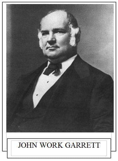
The town of Garrett is situated in Somerset County, Pennsylvania. Nestled between Buffalo Creek and the Casselman River, its origins are inseparable from the rise of the railroad industry. Named after John Work Garrett, the influential president of the Baltimore and Ohio Railroad, the town emerged as a critical railroad junction point for the region.
Established in 1869, it thrived as a hub where the rail lines converged, which helped power the region’s economic growth.
The Baltimore & Ohio Railroad (also known at the time as the Pittsburgh & Connellsville Railroad) served as a means of transportation and a lifeline connecting communities and fueling industries. Integral to this network was the Berlin Branch Railroad, initially built by the Buffalo Valley Railroad Company in 1871. This 8.5-mile branch, connecting the nearby town of Berlin to the main line through Garrett, was later absorbed by the B&O Railroad, enhancing Garrett’s role as a crucial intersection in the expansive rail network.
During its peak, Garrett buzzed with activity, its tracks carrying coal, goods, and passengers. The town prospered from the railroads and featured several hotels, an opera house, an art gallery, and a music studio. A trolley line connected Garrett with Meyersdale.
The Western Maryland Railroad came to Garrett in 1911, with its tracks laid on the southern side of the Casselman River.

As railroads receded with the advent of modern transportation, the Western Maryland Railroad and its holdings were eventually acquired by CSX, itself a company created from railroad mergers including the Chesapeake & Ohio and the Baltimore & Ohio. The tracks of the Western Maryland Railroad through the area were abandoned, and later the land was provided to the Regional Trail Corporation, ultimately resulting in the creation of the Great Allegheny Passage.
The town of Garrett has continued to adapt, and while not as populous as in its railroad heyday, still plays a genial host to the region’s visitors who use the trail system.
And Garrett’s adaptive spirit isn’t over yet. CSX trains still roll through the town to this day, as a vital and active rail link for goods and materials. Amtrak uses the rail lines through Garrett for passenger service between Washington, D.C, Pittsburgh, and other points west.
Garrett is also tapped as a crucial link in the September 11th National Memorial Trail, a 1,300-mile multi-use and multi-mode (trail and on-road) route, that connects the major memorial areas impacted on that day.

The C&O Canal Towpath Trail and the Great Allegheny Passage are two major trail routes designated as part of the September 11th National Memorial Trail, and Garrett is the hub for Great Allegheny Passage trail users wanting to continue north along the designated “911NMT” route to the Flight 93 Memorial in Shanksville.
CSX donated the former Berlin Branch rail bed and right-of-way to Somerset County to create the link between the Great Allegheny Passage trailhead at Garrett, and the Flight 93 Memorial site. It’s hoped that development and construction along this right-of-way will commence so that this crucial link will be able to be taken off-road.
Garrett is an example of small-town resilience and adaptability. It has a rich history, yet is eager to embrace its modern role as a gateway for outdoor adventures. Garrett remains a small town with a big story that continues to unfold and inspire.
Trail Details
Trail Length
Starting at the Garrett trailhead parking area, this segment from Garrett to Rockwood is 7.1 miles according to GAPTrail.org, and 7.3 miles per Google Maps. The 2/10 mile difference appears to be due to where each entity places the trailhead markers. As per usual, I’m going with the official Great Allegheny Passage Conservancy measurement, since we will be following their ground-level mile markers.
Trail Surface
The treadway surface is primarily crushed limestone. At the trailhead, the trail passes under Berlin Street, and the treadway is paved here, as is the last several tenths of a mile at the Rockwood trailhead east and west parking (see below).
The average treadway width in this segment is 8-10 feet, but expands to almost 14 feet about a mile from the Rockwood trailhead east parking area, which is likely due to the need for utility vehicle access to a nearby utility building.
Trail Signage
The Great Allegheny Passage utilizes standardized signage, as I mentioned more specifically in my overview of the trail [here].
Trail Views
This trail segment is nearly pure nature. You ride along the Casselman River and through relaxing forests. There are some interesting water features, including Pletcher Falls, and three streams that pass under the trail and can easily be seen most any time of year. The ride is equal parts of cutting through forested areas and parts very close to the Casselman River, to enjoy its peaceful views.
Oh, and this segment is also a geologist’s paradise as there are numerous geologic formations to be seen.
Trailheads
Garrett (GAP Mile 36.5)
The Garrett trailhead is a large gravel and grass lot, unpaved and unmarked except for a paved pad marked with two handicapped accessible spaces. Overall, this lot can hold over 30 vehicles by utilizing grass parking space along the edges of the gravel lot and the back-to-back arrangement closer to the trailside that can account for about 15 of those over 30 spots.
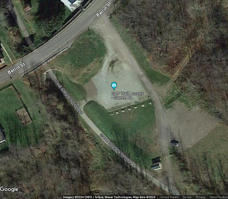
The trailhead features a toilet facility, water fountain, covered seating, bike racks, and a bicycle repair station.

Accessing the trailhead, however, can be tricky for the uninitiated. So it goes like this: From Jackson Street (PA Route 653), the easiest way is to turn right (or left if you’re coming east on PA Route 653) onto Church Street, which crosses over the rail lines, make a left onto Jefferson Street, then a near-immediate right onto Berlin Street, which crosses over the Casselman River. The trailhead is to the left about 700 feet after making the right turn from Jefferson Street. There are road signs pointing to the turn-off for Berlin Street, and the trailhead is marked with the standard GAP signage.
Come prepared however, since at this time there’s what appears to be a small convenience store at the Valero gas station at the intersection of Jackson Street and the Mason-Dixon Highway, but there aren’t many other retail outlets for water or snacks in Garrett, since it is a small residential community now.
Rockwood (GAP Mile 43.8)
I’ll delve into more specifics in the next post, but there are technically two separate parking zones at the Rockwood trailhead.
There is what I’d call the “east lot” that’s on the eastern side of Rockdale Road, and the “main” or “west” lot (obviously on the western side of Rockdale Road) where all of the amenities are, and where the official GAP signage is placed.
The “west” lot should be considered the primary parking and staging area for the Rockwood trailhead. All of the standard amenities are here at the west lot, including bike racks, covered and open seating areas, toilet facilities, and a bicycle repair station.
The main lot is technically split across the trail itself. The larger portion holds about 17 vehicles, while the smaller portion can hold about 5-7 vehicles. The lot is gravel, while the trail that runs through the trailhead is paved.
Also available at the west lot is a snack shop and bike shop, in addition to some cool artwork.
Riding the Trail: Trail Tips
Under Berlin (Street)
Immediately leaving the trailhead itself, the trail goes through a small tunnel-like underpass for Berlin Street. It’s a little longer than the road surface above the trail, but it isn’t lighted.

The Gorge and the Bridge That Wasn’t
After exiting the underpass, you’re treated to some views of seasonal water runoff from the rock faces to the left, and a few houses to the right. Shortly after passing the houses though, you can see what’s called the Casselman Gorge.
Now, I dare you to do a “Google” search on Casselman Gorge, and I’ll bet that the only thing that comes up is the famous one in Maryland, affiliated with the Casselman River Bridge State Park.
But the valley area at Garrett is also known as “Casselman Gorge” and is accessible for watersports, fishing, and nature lovers via Water Works Road, technically a dead-end street opposite the trailhead’s accessway, that runs very close to the river, and also is effectively the “driveway” for those houses I mentioned. At the end of Water Works Road is “Brant’s River Access”, with parking available where Water Works Road connects to the Great Allegheny Passage. It’s a short walk from the parking area down the marked trails to the river.

Google Maps marks Water Works Road with their green “biking” line, and technically this is true because you actually can ride this road all of the way past the houses, where it connects with the Great Allegheny Passage trail itself.
At Brant’s River Access, there’s a curious sight: three stone pylons sit in the river with others on either shore, which clearly indicates that there was a bridge over the river at some point.

But sadly, I haven’t found much historical information about what type of bridge used these pylons, when it was constructed, and when it was removed, or even what the bridge would have been used for.
My guess is that it was a railroad bridge. A satellite view seems to indicate that this may have been a railroad bridge connecting to the Western Maryland Railroad.
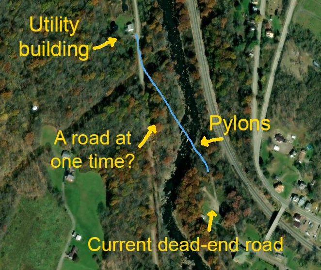
I’d love to hear from anyone who lives in the Garrett area who knows about any specifics about the bridge that was carried along these pylons, because I’ll definitely add it here.
UPDATE: I recently was in touch with representatives from the Somerset County Parks & Trails department. I was informed that a previous department director believes that the pylons were “from an old railroad crossing.” This, according to the source, is based on the fact that “the CSX (formerly B&O) came down from Garrett that way and there are similar ones near Rockwood that were from an old rail crossing.”

The picture above is of the now-disused rail crossing over the Casselman at the Rockwood Station, demonstrating the previous director’s notation of the old rail crossing at Rockwood.
Spotty Cells
This segment is another of several along the Great Allegheny Passage that can have spotty cell service, so make sure you plan for loss of signal. If you’re using a trail app, make sure you download your maps before starting the trail. Oh, and make sure you have enough battery power.
One of the Lesser-Known Waterfalls in Pennsylvania
Around GAP mile 37.5 is one of the hidden gems along the Great Allegheny Passage.
Pletcher Falls is a lesser-known but very picturesque waterfall, with its water cascading over the rocks above, into a tranquil pool below, finally flowing under the trail and into the Casselman River.

There are benches at the location, so you can sit and relax for a bit, and enjoy the peaceful sounds of the water flowing down from the rocks.
While it may be small as far as waterfalls go, this is a serene and beautiful setting that provides a refreshing stop and a great spot to relax and take in the natural surroundings.
What? There’s a Windfarm Up There?
While you may not be able to notice it, around GAP mile 39 there’s a small windfarm on the hill above the trail, as you can see on this satellite photo courtesy of Google Maps. There’s another one on the opposite side of Rockdale Road about a mile away.


Also on the top of the hill opposite the other wind farm, is a large, deforested area that’s the site of “Nittany Mine Pit #2” owned by Rosebud Mining.
This area, as well as a lot of the western Pennsylvania area, has been known for coal mining activities, so it’s no surprise that a large pit mining operation would be in this area.
As I’ll touch on in a bit, close by is what geologists call the “Kittanning Coal Seam”, an exposed part of which can actually be seen from the trail. This pit may still be active, because the company “Rosebud Mining” has an active website.
Islands in the Stream
As you traverse this segment, you can see several islands in the river. All of them appear uninhabited, and perhaps are only accessible by watercraft. But it’s interesting to see how nature has carved the river around these sections of land, so don’t forget to stop along the way and admire the view.
The Three Runs
Traversing the trail, starting around GAP mile 40, is Lick Run. It appears to be a rather dry streambed that has its own unique geologic features as I’ll expand on below. About a mile away, are two other “runs”. When traveling on the trail toward Rockwood, you’ll see Shafer Run first, and then very shortly after crossing over Shafer Run, you’ll encounter Stony Batter Run.


The latter two streams usually have some water flowing most times of the year, but of all of the times I’ve ridden this segment, I’ve rarely seen Lick Run with any appreciable amount of water flow. If you catch a picture of Lick Run full of water, let me know!
What the Heck is THAT?
Shortly after passing the local power company substation around GAP mile 42, there’s a large pile of… something, to the south of the trail.

While I originally thought it was a slag heap of the type seen in the areas around coke ovens, I understand that there weren’t any steel or coke operations in this area.
According a webpage entitled “Waypoints of the Great Allegheny Passage” that was compiled by Kevin Geiserman, this is called the “Gob Pile.” It is a large pile of waste rock and other debris from past mining of the Lower Kittanning coal seam.
The Husky Hollow
Starting around GAP mile 42, the Husky Hollow primitive campground can be seen between the trail and the river. It used to offer multi-day GAP trail users an excellent place to camp, in a location close to the amenities of the borough of Rockwood, which is just on the other side of the river.

Unfortunately, there’s a “closed” sign in front. During a recent discussion with one of the volunteers at the Rockwood trailhead visitor center, she informed me that the campground is permanently closed as the former owners were apparently unable to maintain it. Currently there do not appear to be plans to sell the property and/or have some one other than the previous owners renovate and re-open it.
A River View and a Coal Seam
Just to the east of what I like to call the Rockwood trailhead’s “east parking lot”, there’s a deck built on the edge of the hill overlooking the river. It gives you a nice scenic view of the Casselman, and of the town of Rockwood on the other side of the river… when the foliage isn’t overgrown and obscures the view.
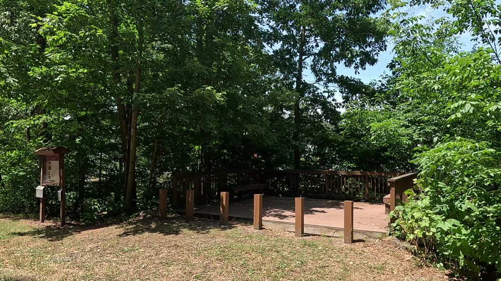
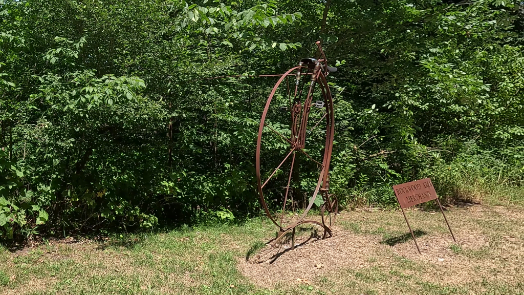
There is also a metal bicycle sculpture placed there by the Rockwood Merchants Association.

On the other side of the trail and just a few more yards away (more parallel to the Husky Hollow), you can see a dark streak through the rock formation.
This is the Lower Kittanning Coal Seam. This is one of the fascinating geologic formations along this segment of the trail, and is somewhat unique because you can actually see part of it when the vegetation surrounding the formation is low.
An Outdoor Geology Classroom

You know, I racked my brain for weeks trying to decipher all of the upright wood poles with numbers and letters on them that you can easily see during your ride (or walk) along this segment.
Now, I mentioned Kevin Geiserman and his compilation webpage on Great Allegheny Passage waypoints earlier, and here’s where I really need to buy this man a coffee… and I might have to stop being so hard on AllTrails.com, too.
The AllTrails curated page for this trail segment notes that:
This section of the trail is an open-air geology classroom with marker posts along the length pointing out specific features.
Although I will still take issue with AllTrails.com for continuing to call many of the Great Allegheny Passage segments as the “Allegheny Highlands Trail.” Personally, I think everyone should adopt the “newer”, all-encompassing name of “Great Allegheny Passage.”
A bit more digging found Kevin’s webpage, that led me to the Pennsylvania DCNR’s page and the online title, “From Rails to Trails to Rocks: Geology of the Garrett-to-Rockwood Section of the Allegheny Highlands Trail” by written by James R. Shaulis and Thomas W. Jones.
Based on their publication and the compilation from Kevin Geiserman, it’s clear that this segment of the trail is literally an open-air geology lab, with examples of several different types of geologic formations that can be seen along Negro Mountain, which this trail segment crosses.
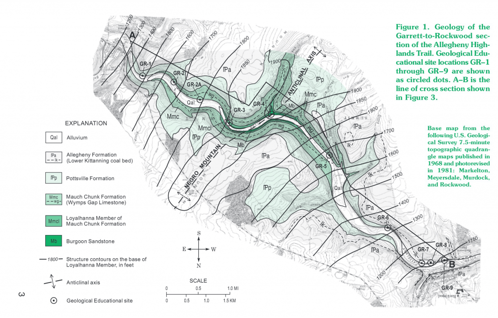
Their freely-accessible online publication features the map that I’ve included above, that shows the various formations and the wooden stake marker numbers for each. Kevin’s webpage expands on those descriptions a bit by including the latitude & longitude coordinates for each marker.

Now I’m no great student of geology, but I could kick myself for how many times I’ve just ridden by some of these features and had no idea what they were.
For instance, I had no idea that Lick Run is also the alignment of what geologists call the “anticlinal axis” for Negro Mountain, and would be the high point of the fold (if not for erosion from Lick Run). Apparently in structural geology, an anticline is a type of fold that is in an arch-like shape and has its oldest rock beds at its core. It’s also noted that something called the horizontally-laying rocks in the Lick Run creek bed are “Burgoon sandstone”.
I guess you learn something new every day.
I highly recommend that you look up what each of these features are, and then explore them on your next ride or hike on this segment!
Trail Impression
The Garrett to Rockwood segment is a sub-10-mile point to point segment that’s easy to ride, and offers a peaceful passage through lush forests and striking, unspoiled river views, along with the serenity of a waterfall tucked into the rock face beside the trail. The geologic features along this segment are, in my opinion, icing on the cake for enjoying the scenery around you as you ride or hike this seemingly unobtrusive segment of the Great Allegheny Passage!